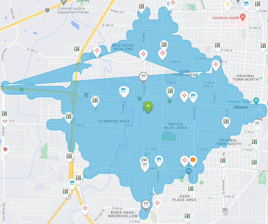
I am currently not able to figure out what is causing the abnormal shape when drawing a polygon onto the map as shown below.
Instead of being a complete polygon, there seems to be a triangle in the middle?
I am using SQL geometry library in a DotNet app to buffer given array of coordinates.
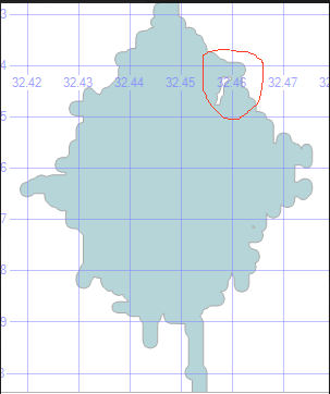
When I use SQLGeometry in SSMS the Polygon seems fine as shown below, however there seems to be an Island as circled red.
Here is a SQL query to generate it
DECLARE @distance float = 75;
DECLARE @shape nvarchar(max) = 'POLYGON((32.4549866 -99.8079586,32.4548149
-99.8075294,32.4544716 -99.8071861,32.4542999 -99.8066711,32.4542999
-99.7998047,32.4541283 -99.7992897,32.4537849 -99.7989464,32.4536133
-99.7984314,32.4536133 -99.7901917,32.4534416 -99.7896767,32.4530983 -99.7893333,32.4529266 -99.7888184,32.4530983 -99.7883034,32.4534416 -99.7879601,32.4537849 -99.7869301,32.4548149 -99.7865868,32.4551582 -99.7862434,32.4556732 -99.7860718,32.4570465 -99.7860718,32.4575615 -99.7859001,32.4577332 -99.7853851,32.4575615 -99.7848701,32.4565315 -99.7845268,32.4561882 -99.7841835,32.4551582 -99.7838402,32.4549866 -99.7833252,32.4551582 -99.7828102,32.4556732 -99.7826385,32.4561882 -99.7828102,32.4565315 -99.7831535,32.4570465 -99.7833252,32.4577332 -99.7833252,32.4582481 -99.7831535,32.4584198 -99.7826385,32.4584198 -99.7819519,32.4585915 -99.7814369,32.4589348 -99.7810936,32.4591064 -99.7805786,32.4591064 -99.779892,32.4592781 -99.779377,32.4597931 -99.7792053,32.4603081 -99.779377,32.4606514 -99.780407,32.4609947 -99.7807503,32.4611664 -99.7812653,32.4611664 -99.7826385,32.461338 -99.7831535,32.461853 -99.7833252,32.462368 -99.7831535,32.4625397 -99.7826385,32.4625397 -99.7805786,32.4627113 -99.7800636,32.4637413 -99.7797203,32.463913 -99.7792053,32.4637413 -99.7786903,32.463398 -99.778347,32.463398 -99.7780037,32.4644279 -99.7776604,32.4645996 -99.7771454,32.4644279 -99.7766304,32.463398 -99.7762871,32.4627113 -99.7756004,32.4625397 -99.7750854,32.4625397 -99.7743988,32.4627113 -99.7738838,32.4632263 -99.7737122,32.4645996 -99.7737122,32.4651146 -99.7735405,32.4652863 -99.7730255,32.4651146 -99.7725105,32.4645996 -99.7723389,32.463913 -99.7723389,32.463398 -99.7721672,32.4632263 -99.7716522,32.4632263 -99.7709656,32.463398 -99.7704506,32.463913 -99.7702789,32.4644279 -99.7704506,32.4654579 -99.7714806,32.4658012 -99.7714806,32.4659729 -99.7709656,32.4659729 -99.7675323,32.4661446 -99.7670174,32.4666595 -99.7668457,32.4671745 -99.7670174,32.4673462 -99.7675323,32.4673462 -99.768219,32.4675179 -99.768734,32.4680328 -99.7689056,32.4685478 -99.768734,32.4687195 -99.768219,32.4687195 -99.7668457,32.4688911 -99.7663307,32.4694061 -99.7661591,32.4699211 -99.7663307,32.4702644 -99.766674,32.4707794 -99.7668457,32.4712944 -99.766674,32.4714661 -99.7661591,32.4714661 -99.7654724,32.4716377 -99.7649574,32.4721527 -99.7647858,32.4728394 -99.7647858,32.4733543 -99.7649574,32.4736977 -99.7653008,32.474041 -99.7653008,32.4747276 -99.7646141,32.4748993 -99.7640991,32.4748993 -99.7634125,32.4747276 -99.7628975,32.4742126 -99.7627258,32.4736977 -99.7628975,32.4733543 -99.7632408,32.4728394 -99.7634125,32.4721527 -99.7634125,32.4716377 -99.7632408,32.4714661 -99.7627258,32.4714661 -99.7592926,32.4716377 -99.7587776,32.4721527 -99.758606,32.473526 -99.758606,32.474041 -99.7587776,32.4743843 -99.7591209,32.4747276 -99.7591209,32.4748993 -99.758606,32.4748993 -99.756546,32.4747276 -99.756031,32.4743843 -99.756031,32.474041 -99.757061,32.473526 -99.7572327,32.473011 -99.757061,32.4726677 -99.756031,32.4716377 -99.7556877,32.4709511 -99.7550011,32.4706078 -99.7539711,32.4700928 -99.7537994,32.4695778 -99.7539711,32.4694061 -99.7544861,32.4694061 -99.7551727,32.4692345 -99.7556877,32.4687195 -99.7558594,32.4680328 -99.7558594,32.4675179 -99.7556877,32.4673462 -99.7551727,32.4673462 -99.7517395,32.4671745 -99.7512245,32.4668312 -99.7512245,32.4666595 -99.7517395,32.4666595 -99.7531128,32.4664879 -99.7536278,32.4661446 -99.7536278,32.4659729 -99.7531128,32.4659729 -99.7503662,32.4658012 -99.7498512,32.4652863 -99.7496796,32.4645996 -99.7496796,32.4640846 -99.7495079,32.463913 -99.7489929,32.463913 -99.7476196,32.4637413 -99.7471046,32.4627113 -99.7467613,32.4625397 -99.7462463,32.4625397 -99.7455597,32.462368 -99.7450447,32.461338 -99.7447014,32.4611664 -99.7441864,32.4611664 -99.7428131,32.4609947 -99.7422981,32.4606514 -99.7422981,32.4603081 -99.7433281,32.4592781 -99.7436714,32.4591064 -99.7441864,32.4591064 -99.7455597,32.4589348 -99.7460747,32.4585915 -99.746418,32.4584198 -99.746933,32.4584198 -99.7476196,32.4582481 -99.7481346,32.4577332 -99.7483063,32.4563599 -99.7483063,32.4558449 -99.7481346,32.4556732 -99.7476196,32.4558449 -99.7471046,32.4561882 -99.7467613,32.4563599 -99.7462463,32.4561882 -99.7457314,32.4558449 -99.745388,32.4558449 -99.7450447,32.4568748 -99.7447014,32.4570465 -99.7441864,32.4570465 -99.7421265,32.4572182 -99.7416115,32.4577332 -99.7414398,32.4611664 -99.7414398,32.4616814 -99.7412682,32.461853 -99.7407532,32.4616814 -99.7402382,32.4611664 -99.7400665,32.4591064 -99.7400665,32.4585915 -99.7398949,32.4582481 -99.7395515,32.4572182 -99.7392082,32.4561882 -99.7381783,32.4556732 -99.7380066,32.4549866 -99.7380066,32.4544716 -99.7378349,32.4542999 -99.7373199,32.4542999 -99.7366333,32.4541283 -99.7361183,32.4537849 -99.735775,32.4534416 -99.734745,32.4524117 -99.7344017,32.4520683 -99.7333717,32.4515533 -99.7332001,32.4510384 -99.7333717,32.450695 -99.7337151,32.4503517 -99.7337151,32.4501801 -99.7332001,32.4501801 -99.7318268,32.4500084 -99.7313118,32.4489784 -99.7309685,32.4488068 -99.7304535,32.4488068 -99.7263336,32.4486351 -99.7258186,32.4481201 -99.725647,32.4474335 -99.725647,32.4469185 -99.7258186,32.4467468 -99.7263336,32.4469185 -99.7268486,32.4472618 -99.7271919,32.4474335 -99.7277069,32.4472618 -99.7282219,32.4467468 -99.7283936,32.4460602 -99.7283936,32.4455452 -99.7285652,32.4453735 -99.7290802,32.4453735 -99.7297668,32.4455452 -99.7302818,32.4458885 -99.7306252,32.4458885 -99.7309685,32.4448586 -99.7313118,32.4448586 -99.7316551,32.4458885 -99.7319984,32.4460602 -99.7325134,32.4458885 -99.7330284,32.4453735 -99.7332001,32.4446869 -99.7332001,32.4441719 -99.7333717,32.4438286 -99.7337151,32.4433136 -99.7338867,32.442627 -99.7338867,32.442112 -99.7340584,32.4419403 -99.7345734,32.4419403 -99.7366333,32.4417686 -99.7371483,32.4412537 -99.7373199,32.440567 -99.7373199,32.440052 -99.7374916,32.4397087 -99.7378349,32.4391937 -99.7380066,32.4385071 -99.7380066,32.4379921 -99.7381783,32.4378204 -99.7386932,32.4379921 -99.7392082,32.4385071 -99.7393799,32.4390221 -99.7392082,32.4393654 -99.7388649,32.4398804 -99.7386932,32.4403954 -99.7388649,32.440567 -99.7393799,32.4403954 -99.7398949,32.4398804 -99.7400665,32.4391937 -99.7400665,32.4386787 -99.7402382,32.4385071 -99.7407532,32.4385071 -99.7421265,32.4383354 -99.7426414,32.4362755 -99.7447014,32.4352455 -99.7450447,32.4349022 -99.7460747,32.4343872 -99.7462463,32.4337006 -99.7462463,32.4331856 -99.7460747,32.4321556 -99.7450447,32.4318123 -99.7450447,32.4316406 -99.7455597,32.4316406 -99.746933,32.431469 -99.747448,32.430954 -99.7476196,32.4295807 -99.7476196,32.4290657 -99.7477913,32.428894 -99.7483063,32.4290657 -99.7488213,32.4295807 -99.7489929,32.430954 -99.7489929,32.431469 -99.7491646,32.4316406 -99.7496796,32.4316406 -99.7510529,32.431469 -99.7515678,32.430439 -99.7519112,32.4302673 -99.7524261,32.4302673 -99.7544861,32.4300957 -99.7550011,32.4290657 -99.7553444,32.428894 -99.7558594,32.428894 -99.7572327,32.4287224 -99.7577477,32.4280357 -99.7584343,32.4275208 -99.758606,32.4268341 -99.758606,32.4263191 -99.7587776,32.4261475 -99.7592926,32.4263191 -99.7598076,32.4268341 -99.7599792,32.4275208 -99.7599792,32.4280357 -99.7601509,32.4282074 -99.7606659,32.4282074 -99.7613525,32.4280357 -99.7618675,32.4275208 -99.7620392,32.4247742 -99.7620392,32.4242592 -99.7622108,32.4239159 -99.7625542,32.4235725 -99.7625542,32.4232292 -99.7622108,32.4227142 -99.7620392,32.4221992 -99.7622108,32.4218559 -99.7625542,32.420826 -99.7628975,32.4204826 -99.7632408,32.4194527 -99.7635841,32.419281 -99.7640991,32.4194527 -99.7646141,32.4199677 -99.7647858,32.4204826 -99.7646141,32.420826 -99.7642708,32.4213409 -99.7640991,32.4234009 -99.7640991,32.4239159 -99.7642708,32.4240875 -99.7647858,32.4240875 -99.7654724,32.4242592 -99.7659874,32.4249458 -99.766674,32.4259758 -99.7670174,32.4263191 -99.7673607,32.4268341 -99.7675323,32.4295807 -99.7675323,32.4300957 -99.767704,32.4300957 -99.7680473,32.4295807 -99.768219,32.428894 -99.768219,32.4283791 -99.7683907,32.4282074 -99.7689056,32.4282074 -99.7702789,32.4283791 -99.7707939,32.428894 -99.7709656,32.4295807 -99.7709656,32.4300957 -99.7711372,32.431469 -99.7725105,32.4316406 -99.7730255,32.4316406 -99.7785187,32.431469 -99.7790337,32.4311256 -99.779377,32.4307823 -99.780407,32.430439 -99.7807503,32.4302673 -99.7812653,32.4302673 -99.7819519,32.430439 -99.7824669,32.430954 -99.7826385,32.431469 -99.7824669,32.4318123 -99.7814369,32.4321556 -99.7810936,32.4323273 -99.7805786,32.4323273 -99.779892,32.4324989 -99.779377,32.4328423 -99.779377,32.4331856 -99.780407,32.4337006 -99.7805786,32.4343872 -99.7805786,32.4349022 -99.7807503,32.4350739 -99.7812653,32.4350739 -99.7819519,32.4352455 -99.7824669,32.4359322 -99.7831535,32.4362755 -99.7831535,32.4364471 -99.7826385,32.4364471 -99.7812653,32.4366188 -99.7807503,32.4369621 -99.7807503,32.4371338 -99.7812653,32.4371338 -99.7833252,32.4373055 -99.7838402,32.4378204 -99.7840118,32.4383354 -99.7838402,32.4385071 -99.7833252,32.4385071 -99.7826385,32.4386787 -99.7821236,32.4390221 -99.7821236,32.4391937 -99.7826385,32.4391937 -99.7840118,32.4393654 -99.7845268,32.440052 -99.7852135,32.441082 -99.7855568,32.441082 -99.7859001,32.4403954 -99.7865868,32.4398804 -99.7867584,32.4378204 -99.7867584,32.4373055 -99.7869301,32.4373055 -99.7872734,32.4378204 -99.7874451,32.4391937 -99.7874451,32.4397087 -99.7876167,32.440052 -99.7879601,32.440567 -99.7881317,32.4419403 -99.7881317,32.4424553 -99.7883034,32.4427986 -99.7893333,32.4431419 -99.7896767,32.4433136 -99.7901917,32.4433136 -99.7936249,32.4434853 -99.7941399,32.4440002 -99.7943115,32.4445152 -99.7941399,32.4446869 -99.7936249,32.4446869 -99.7901917,32.4448586 -99.7896767,32.4452019 -99.7893333,32.4455452 -99.7883034,32.4462318 -99.7876167,32.4467468 -99.7874451,32.4472618 -99.7876167,32.4474335 -99.7881317,32.4474335 -99.7888184,32.4476051 -99.7893333,32.4481201 -99.789505,32.4508667 -99.789505,32.4513817 -99.7896767,32.4515533 -99.7901917,32.4515533 -99.7915649,32.451725 -99.7920799,32.4520683 -99.7924232,32.45224 -99.7929382,32.45224 -99.7984314,32.4520683 -99.7989464,32.451725 -99.7992897,32.4515533 -99.7998047,32.451725 -99.8003197,32.452755 -99.800663,32.4529266 -99.801178,32.4529266 -99.8073578,32.4530983 -99.8078728,32.4537849 -99.8085594,32.4542999 -99.8087311,32.4548149 -99.8086452,32.4549866 -99.8083878,32.4549866 -99.8079586))';

DECLARE @g geometry;
SET @g = geometry::STGeomFromText(@shape, 4326).STBuffer(@distance * 0.00001).MakeValid();
SELECT @g, @g.STBuffer(@distance * 0.00001).ToString();
This is the function written in C# that generates the coordinates for the Map
public double[][] BufferCoordinates(List<string> coordinates, float bufferDistance)
{
        try
        {

            var shapeString = $"POLYGON(({string.Join(',', coordinates)}))";
            var shape = new SqlChars(shapeString);

            var sqlGeometry = SqlGeometry.STGeomFromText(shape, spatialRefId);

            var buffering = sqlGeometry.STBuffer(bufferDistance / bufferTolerance)
                                        .ToString()
                                        .Replace("POLYGON ((", "")
                                        .Replace("))", "")
                                        .Split(',')
                                        .Select(c => c.Trim());

            var bufferedCoordinates = buffering
                                   .Select(c => c.Replace("(", "").Replace(")", "").Split(' '))
                                   .Where(c => c.Length > 1)
                                   .Select(c => new double[] { Convert.ToDouble(c[0]), Convert.ToDouble(c[1]) })
                                   .ToArray();

            return bufferedCoordinates;

        }
        catch (Exception ex)
        {
            _logger.LogError(ex.ToString());
        }
        throw new Exception("Failed to generate coordinates");
    }
One thing I noticed, when the original input coordinates are buffered I get two sets of coordinates?
Could it be due to presence of inner Island(s)? If yes then how can I avoid that?


MakeValid()in SQL and C# code and it output the same results.