Related to a previous question, I need to crop my dataset for visualization purposes. By crop I mean getting rid of the nodata values and rotating the result.
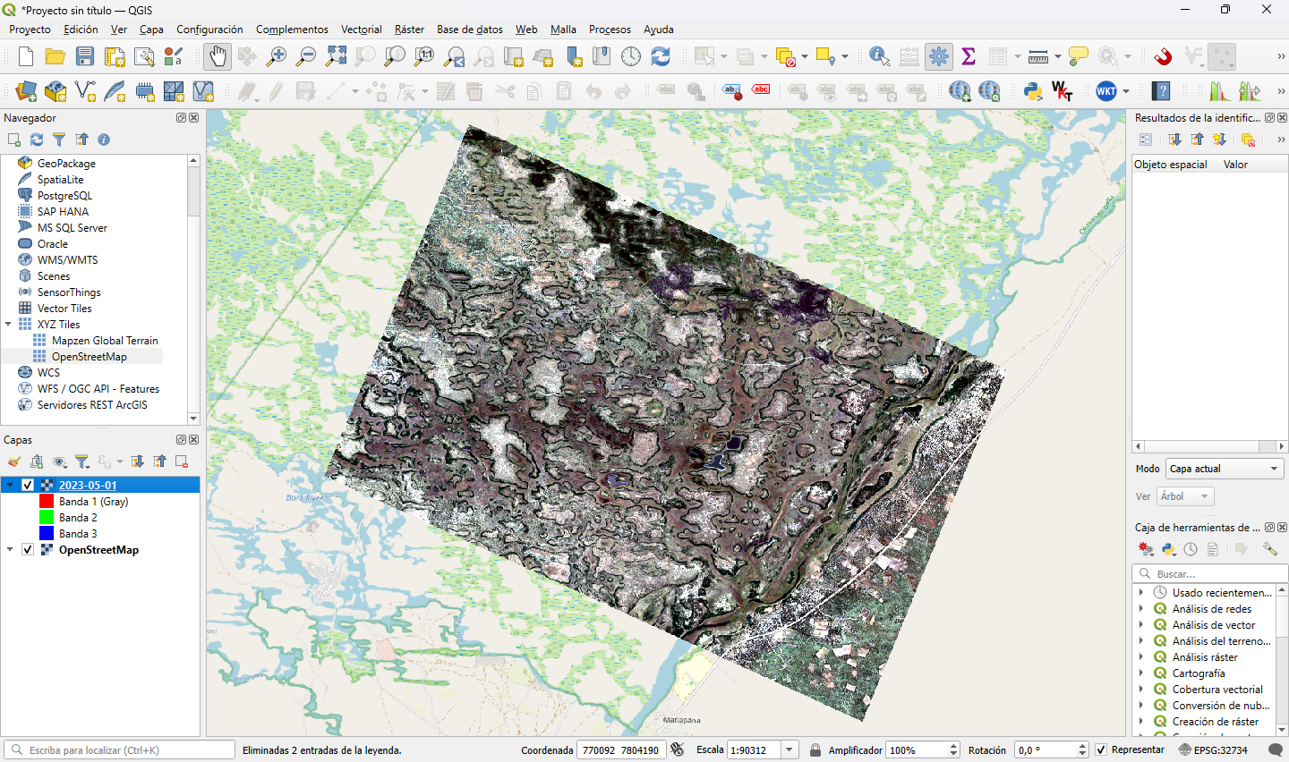
My raster originally looks like this:
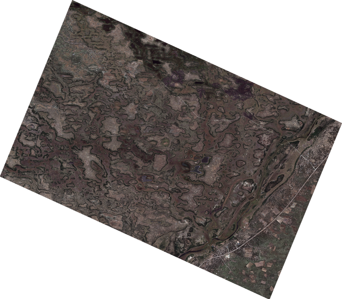
I am able to export the raster as a PNG using gdal_translate as in gdal_translate -of PNG downloads\2023-05-01.tiff test.png -scale -ot Byte but this returns the image as a rotated PNG. 
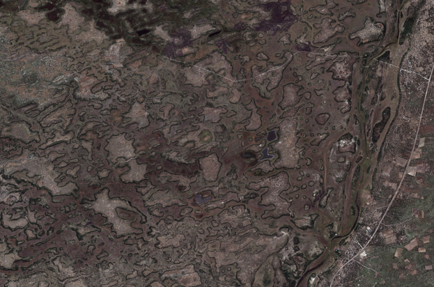
I would like to undo this geometric transformation and obtain something like this even if it means losing information, georreferentiation or resampling:
Not sure if this can be done only with GDAL, but I'm using the Python bindings, so I have much more tools available besides GDAL if not possible. I'm unsure how this operation is called, so I don't know where or what to look for in the docs.
Running gdalinfo for my dataset as gdalinfo -stats downloads/2023-05-01.tiff outputs the following:
Driver: GTiff/GeoTIFF
Files: downloads/2023-05-01.tiff
Size is 1818, 1593
Coordinate System is:
PROJCRS["WGS 84 / UTM zone 34S",
    BASEGEOGCRS["WGS 84",
        DATUM["World Geodetic System 1984",
            ELLIPSOID["WGS 84",6378137,298.257223563,
                LENGTHUNIT["metre",1]]],
        PRIMEM["Greenwich",0,
            ANGLEUNIT["degree",0.0174532925199433]],
        ID["EPSG",4326]],
    CONVERSION["UTM zone 34S",
        METHOD["Transverse Mercator",
            ID["EPSG",9807]],
        PARAMETER["Latitude of natural origin",0,
            ANGLEUNIT["degree",0.0174532925199433],
            ID["EPSG",8801]],
        PARAMETER["Longitude of natural origin",21,
            ANGLEUNIT["degree",0.0174532925199433],
            ID["EPSG",8802]],
        PARAMETER["Scale factor at natural origin",0.9996,
            SCALEUNIT["unity",1],
            ID["EPSG",8805]],
        PARAMETER["False easting",500000,
            LENGTHUNIT["metre",1],
            ID["EPSG",8806]],
        PARAMETER["False northing",10000000,
            LENGTHUNIT["metre",1],
            ID["EPSG",8807]]],
    CS[Cartesian,2],
        AXIS["(E)",east,
            ORDER[1],
            LENGTHUNIT["metre",1]],
        AXIS["(N)",north,
            ORDER[2],
            LENGTHUNIT["metre",1]],
    USAGE[
        SCOPE["Navigation and medium accuracy spatial referencing."],
        AREA["Between 18┬░E and 24┬░E, southern hemisphere between 80┬░S and equator, onshore and offshore. Angola. Botswana. Democratic Republic of the Congo (Zaire). Namibia. South Africa. Zambia."],
        BBOX[-80,18,0,24]],
    ID["EPSG",32734]]
Data axis to CRS axis mapping: 1,2
Origin = (755100.000000000000000,7811940.000000000000000)
Pixel Size = (10.000000000000000,-10.000000000000000)
Metadata:
  AREA_OR_POINT=Area
Image Structure Metadata:
  LAYOUT=COG
  COMPRESSION=LZW
  INTERLEAVE=PIXEL
Corner Coordinates:
Upper Left  (  755100.000, 7811940.000) ( 23d26' 4.68"E, 19d46'18.38"S)
Lower Left  (  755100.000, 7796010.000) ( 23d26'12.58"E, 19d54'56.15"S)
Upper Right (  773280.000, 7811940.000) ( 23d36'28.84"E, 19d46' 9.57"S)
Lower Right (  773280.000, 7796010.000) ( 23d36'37.30"E, 19d54'47.28"S)
Center      (  764190.000, 7803975.000) ( 23d31'20.85"E, 19d50'32.92"S)
Band 1 Block=512x512 Type=UInt16, ColorInterp=Gray
  Minimum=1077.000, Maximum=13880.000, Mean=2018.113, StdDev=351.323
  NoData Value=0
  Overviews: 909x796, 454x398, 227x199
  Offset: -0.1,   Scale:0.0001
  Metadata:
    STATISTICS_MINIMUM=1077
    STATISTICS_MAXIMUM=13880
    STATISTICS_MEAN=2018.1125217712
    STATISTICS_STDDEV=351.32337310468
    STATISTICS_VALID_PERCENT=55.21
Band 2 Block=512x512 Type=UInt16, ColorInterp=Undefined
  Minimum=1073.000, Maximum=12488.000, Mean=1811.102, StdDev=233.957
  NoData Value=0
  Overviews: 909x796, 454x398, 227x199
  Offset: -0.1,   Scale:0.0001
  Metadata:
    STATISTICS_MINIMUM=1073
    STATISTICS_MAXIMUM=12488
    STATISTICS_MEAN=1811.1022441941
    STATISTICS_STDDEV=233.95662853744
    STATISTICS_VALID_PERCENT=55.21
Band 3 Block=512x512 Type=UInt16, ColorInterp=Undefined
  Minimum=1065.000, Maximum=9832.000, Mean=1572.875, StdDev=191.223
  NoData Value=0
  Overviews: 909x796, 454x398, 227x199
  Offset: -0.1,   Scale:0.0001
  Metadata:
    STATISTICS_MINIMUM=1065
    STATISTICS_MAXIMUM=9832
    STATISTICS_MEAN=1572.8751681504
    STATISTICS_STDDEV=191.22301182326
    STATISTICS_VALID_PERCENT=55.21


