5

QGIS 2.0 Working with tiff raster file. Reprojections are in WGS84 Mercator.

Here is my problem: I am trying to use buffers or urban areas to analyze light intensity on a raster layer. I want 30 miles, 60 miles, and 100 miles for the buffer sizes. I have reprojected the vector layers to WGS84 / World Mercator. When I ran a zonal statistics, everything went smoothly until I was double-checking the output. I saw "null" on a few of the rows of information in the data table. When I looked at the raster image, which I also reprojected to WGS84 / World Mercator, a large chunk of the raster layer was missing. Images below.

Non-reprojected raster layer: enter image description here
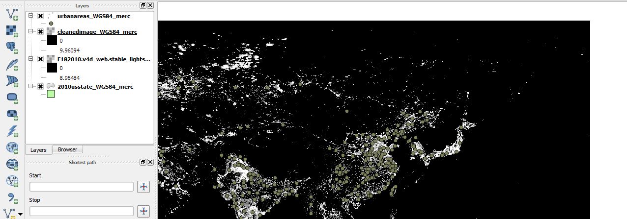
Reprojected raster layer: enter image description here

I am assuming there is a problem with my reprojections. I am still new at GIS, so please bear with me. Thanks in advance.

3
  • Welcome to GIS StackExchange. According to the screen shot, there is a raster layer in the second image that is not checked in the layer control. Is it the missing part? What tool did you use to reproject the raster? Commented Feb 20, 2014 at 18:43
  • The unchecked layer is the original, non-reprojected tiff image. I put them in the same project to easily screenshot the difference. If I pull zonal statistics from the second image, I get the null inputs on parts of China and Japan. If I pull zonal statistics on the first image, I get null across the board. I reprojected by "save as..."
    – ian
    Commented Feb 20, 2014 at 18:53
  • 1
    see this post for raster reprojection info: gis.stackexchange.com/questions/38984/… , I suggest you to use GDALtool instead of save as Commented Feb 20, 2014 at 18:55

1 Answer 1

2

Looking at your image, I guess you are working on Asia, and the missing part is on the other side of 180°E/W. So you might find your data West of America.

You could reproject to another CRS based on some Asian meridian to avoid this.

By the way, World Mercator uses metres as units, but these are only true meters at the equator.

5
  • Thank you for the response. I am currently attempting Below the Radar's method. While I wait for the reprojection, I will tell you that I am looking at the entire globe. I have a vector layer of the 300 largest MSAs in the world. I will then draw a buffer in varying sizes around those points and analyze the light intensity within. Is there a better projection than World Mercator?
    – ian
    Commented Feb 20, 2014 at 19:35
  • world mercator is well known projection because used in many web maps like openstreetmap or google map, but maybe not the best for spatial analyses like you want to do, see this excellent website to choose the right projection for your need. Commented Feb 21, 2014 at 0:47
  • 1
    The boundary goes through South Korea, just west of Japan, and well west of the 180 degree meridian. I'm having exactly the same problem, with different data but apparently cutting off at exactly the same place -- around 128 degrees east.
    – Max
    Commented Jul 26, 2014 at 21:42
  • @Max What CRS does the original raster layer have?
    – AndreJ
    Commented Jul 27, 2014 at 10:55
  • @AndreJoost: in my case the original had WGS84 and I'm outputting Mollweide; reprojecting the raster layer did the trick.
    – Max
    Commented Jul 27, 2014 at 12:52

Your Answer

By clicking “Post Your Answer”, you agree to our terms of service and acknowledge you have read our privacy policy.

Not the answer you're looking for? Browse other questions tagged or ask your own question.