2

I am trying to build a small application (silverlight based) that would allow creation of layer package based on an area of interest. I have identified a GP tool that does this. The tool is located in Data Management Tools > Package section. I have a model that allows user input as parameters. The issue that I am having is that it takes multiple layers as input and It doesn't allow me to set the datatype as Featureset. AFAIK, to be able to publish this as service, it needs to be feature set NOT feature layer.

I am looking for some input if someone had any suggestions on how to publish this as a GP service OR if there are any other options to do this. Being a system script, I don't have access to the script.
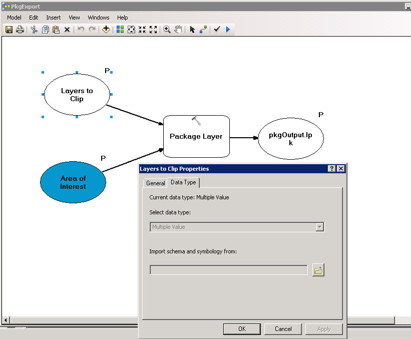
enter image description here

2 Answers 2

2

You pretty much have it although I'm not sure what you mean it has to be a feature set because it doesn't. The tool will take multiple feature layers as input. The Data Extraction tool works in a similar way.

You may be missing the part where this needs to be a tool layer. With your model as is (it looks correct from the screen shot), drag it into your Table of Contents. Right-click and open it. Set some default values and click apply/close. (or run it if you want, just to be sure). Save the mxd, and publish the MXD. You'll get a map service and a GP Service.

Consume the service in ArcMap and it should give you what you want.

If this doesn't answer your question, explain in more detail why you need to use a feature set as input to the layers.

1
  • Thanks for the feedback. I have read somewhere that any Gp tool as part of a map/gp service can only accept feature set not feature layers. I get as an error when I analyze my mxd in Arcmap before publishing. The layer package tool accepts multiple layers and it doesnt give me an option for changing input to feture set. Thanks Jay
    – jayGIS
    Commented May 6, 2011 at 14:47
0

I think I understand the problem now.

It looks like you are trying to combine the extract data task and the package layer tool.

I can't see a way to get the layer symbology for more than one layer by anything other than a layer package.

So maybe you want to create an lpk and extract it to a scratch workspace and then use the scratch lyr and data to clip the area of interest, and then recreate the lpk from the clipped scratch data.

2
  • Hi Brad, The objective is to let users run the GP tool from a mapping application and this will create an lpk output. Users will get this out from a link and then open it in ArcGIS Explorer. This is complete workflow that I am trying to accomplish. Thanks Jay
    – jayGIS
    Commented May 4, 2011 at 20:04
  • This would fit for a task I need to accomplish. Can you share?
    – Brad Nesom
    Commented May 5, 2011 at 5:20

Your Answer

By clicking “Post Your Answer”, you agree to our terms of service and acknowledge you have read our privacy policy.

Not the answer you're looking for? Browse other questions tagged or ask your own question.