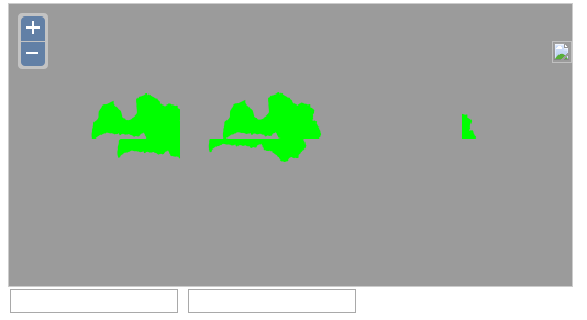
Problem I have: map tiles from my layer are being repeated.
Shapefile is projection 3059. I have specified 3059 is in the mapfile and also when creating map object.
I know OpenLayers.Layer.WMS is recommended, but when I use it I only see empty map. When I use OpenLayers.Layer.MapServer, map is displayed (and tiles are repeated), so I'm using that for now.
My layer (EPSG:3059) looks like this

Versions:
Openlayers 2.13.1
MapServer 6.0.3
WMS Server mapfile:
MAP
    NAME country_map
    STATUS ON
    SIZE 800 500
    EXTENT 313187.4 146161.56 766469.92 470367.64
    UNITS METERS
    SHAPEPATH "shapefiles"
    IMAGECOLOR 155 155 155

    WEB
        TEMPLATE "template.html"
        IMAGEPATH "C:/MS4W/ms4w/apache/htdocs/gis/output/"
        IMAGEURL "/gis/output/"

        METADATA
            "wms_title"             "MapServer + Openlayers"
            "wms_onlineresource"    "http://localhost:1025/cgi-bin/mapserv.exe?map=C:\MS4W\ms4w\Apache\htdocs\gis\mapfile2.map"
            "wms_enable_request"    "*"
            "wms_srs"               "EPSG:3059"
        END
    END

    PROJECTION
        "init=epsg:3059"
    END

# example layer
    LAYER
    METADATA
        "wms_title"             "lat_rob_region"
    END
    NAME "lat_rob_region"
    DATA lat_rob_region
    STATUS ON
    TYPE POLYGON
        CLASS
            NAME "lat_rob_region"
            STYLE
                COLOR 0 255 0
            END
        END
    END
END
Javascript:
var lon = 25;
var lat = 57;
var zoom = 5;
var map, layer1;

function init()
{
    map = new OpenLayers.Map( 'map',{displayProjection: new OpenLayers.Projection("EPSG:3059")} );

    layer1 = new OpenLayers.Layer.MapServer( "Country map",
            "http://localhost:1025/cgi-bin/mapserv.exe?map=C:/MS4W/ms4w/Apache/htdocs/gis/mapfile2.map", {layers: 'lat_rob_region'},
            {gutter: 15},{srs: 'EPSG:3059'});
    map.addLayer(layer1);

    map.setCenter(new OpenLayers.LonLat(lon, lat), zoom);
    map.addControl( new OpenLayers.Control.LayerSwitcher() );
}
