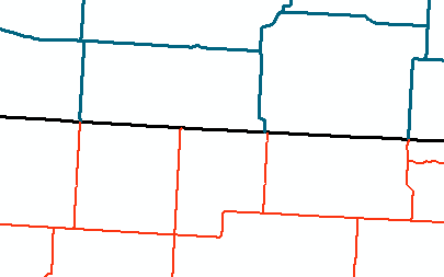
I am trying to match a Canadian road dataset with a US road dataset in ArcGIS 10.1. One way to assess how complete the "matching process" is is by seeing where the roads intersect and where they do NOT intersect (see picture; US roads in red, Canada roads in blue, US-Canada Border in black).
In the picture above, I have three areas where the lines intersect and cross the border and one area where the US road reaches the border but does not have a connection on the other side. Presumably, the one US road (in red) does not just stop at the US-Canada border (in black), but should continue to a Canadian road (in blue). To see where the roads intersect, I use the Intersect tool to create points where the shapefiles intersect. However, I do not have a method to assessing where the US and Canadian roads do NOT intersect.
Question: Is there a way to locate where the US roads and US-Canada border intersect, but where Canadian roads do NOT intersect? Or vice versa with Canadian roads? This would locate where the matching of the two datasets fails, an important thing to assess for my goals.
Any help is appreciated. Thanks in advance.

