Bumped by Community user
added 20 characters in body; edited tags; edited title
Source Link
Taras
  • 34.1k
  • 4
  • 73
  • 148

Creating Polygonspolygons from Pointspoints in Carto

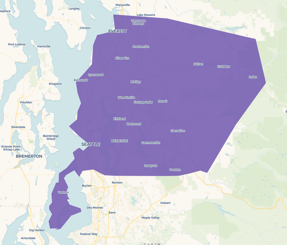
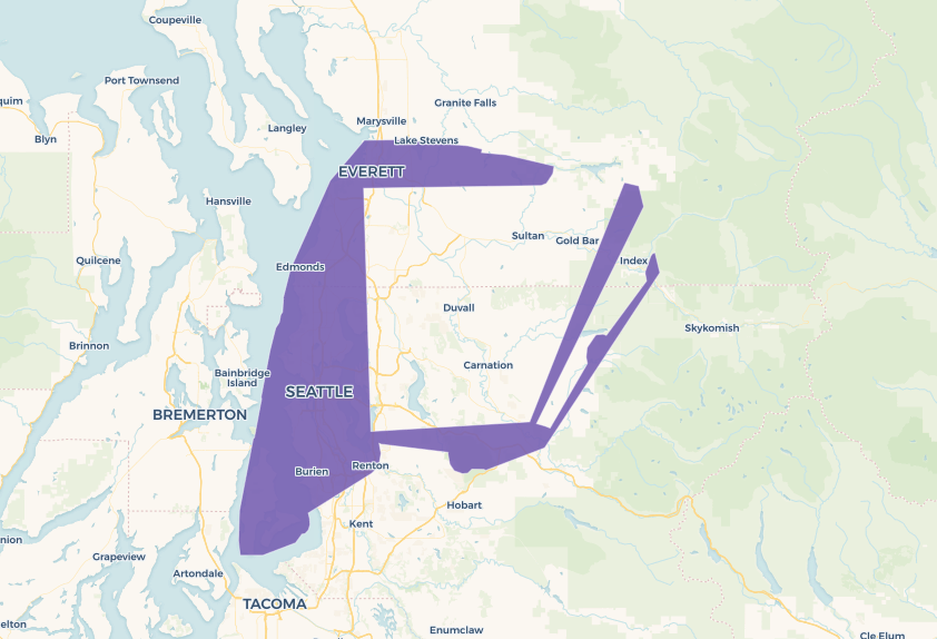
Using Carto, I am trying to create shapefiles of regions using points(Link to Dataset in Carto ) with a shared column value to group by. I'veI've included 3 photographs. 1st photograph of the points outlining the shape. the second photo is my desired result which I have drawn out by hand. The third photo is an attempt that doesntdoes not meet my desired result..

I am using the analysis tool provided by Carto, running a concave hull and have tried various target percent values and without the desired results. For this example I've included a target percent of 80 and the result is shown in a photograph at the bottom. The code is provided below

  SELECT row_number() over() as cartodb_id,
         territoryid as category,
         ST_ConcaveHull(
             ST_Collect(the_geom), 
             0.8, 
             false
          ) AS the_geom,
         count(1) as count_vals
    FROM (
         SELECT *
           FROM ( SELECT * FROM "st-braund".bd_regions_1 ) _camshaft_category_filter
          WHERE territoryid IN (3)
         ) _analysis_source
GROUP BY territoryid
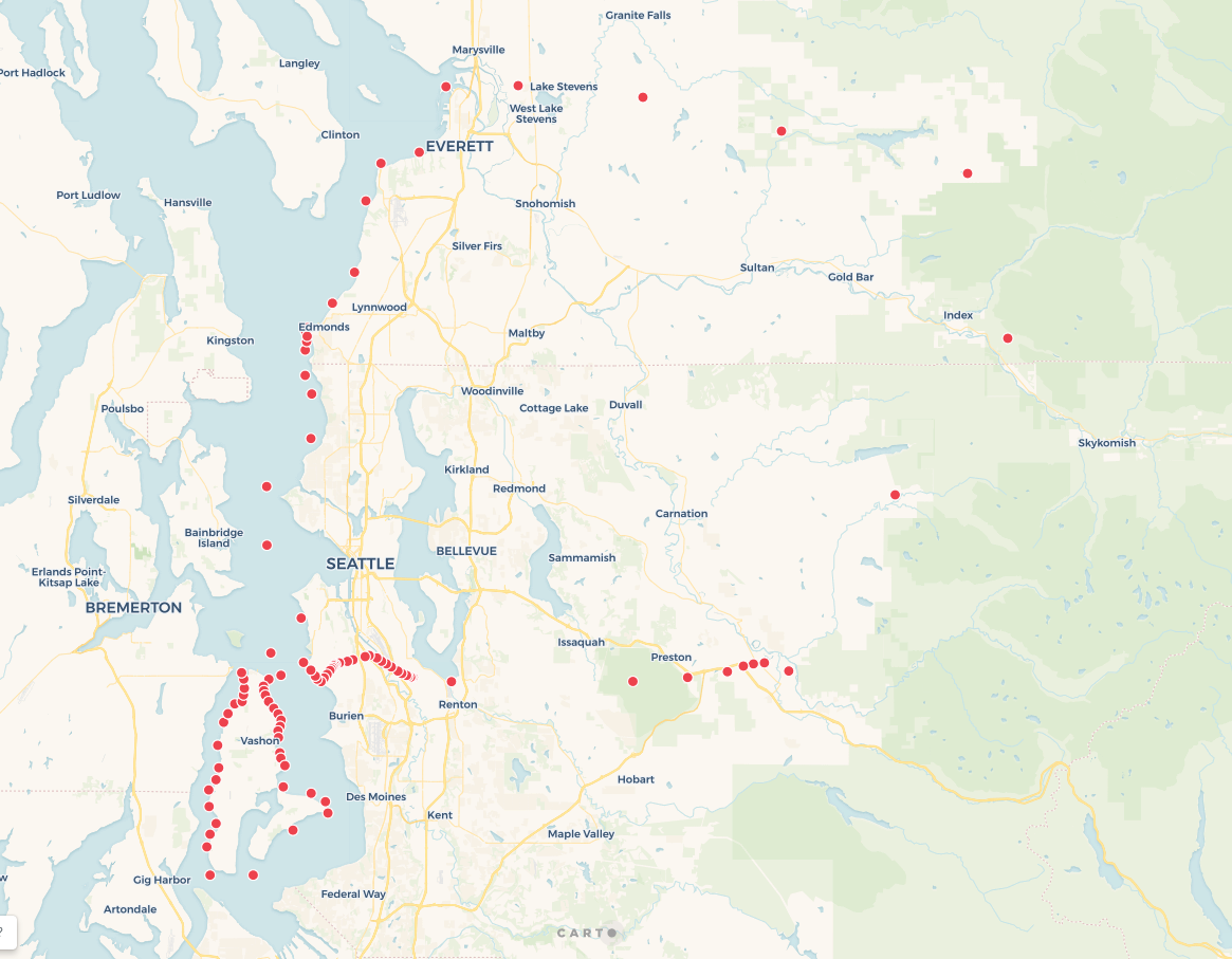
Shape Outline with Points

Desired Shapefile

Failed Attempt

Creating Polygons from Points in Carto

Using Carto, I am trying to create shapefiles of regions using points(Link to Dataset in Carto ) with a shared column value to group by. I've included 3 photographs. 1st photograph of the points outlining the shape. the second photo is my desired result which I have drawn out by hand. The third photo is an attempt that doesnt meet my desired result..

I am using the analysis tool provided by Carto, running a concave hull and have tried various target percent values and without the desired results. For this example I've included a target percent of 80 and the result is shown in a photograph at the bottom. The code is provided below

  SELECT row_number() over() as cartodb_id,
         territoryid as category,
         ST_ConcaveHull(
             ST_Collect(the_geom), 
             0.8, 
             false
          ) AS the_geom,
         count(1) as count_vals
    FROM (
         SELECT *
           FROM ( SELECT * FROM "st-braund".bd_regions_1 ) _camshaft_category_filter
          WHERE territoryid IN (3)
         ) _analysis_source
GROUP BY territoryid
Shape Outline with Points

Desired Shapefile

Failed Attempt

Creating polygons from points in Carto

Using Carto, I am trying to create shapefiles of regions using points(Link to Dataset in Carto ) with a shared column value to group by. I've included 3 photographs. 1st photograph of the points outlining the shape. the second photo is my desired result which I have drawn out by hand. The third photo is an attempt that does not meet my desired result.

I am using the analysis tool provided by Carto, running a concave hull and have tried various target percent values and without the desired results. For this example I've included a target percent of 80 and the result is shown in a photograph at the bottom. The code is provided below

  SELECT row_number() over() as cartodb_id,
         territoryid as category,
         ST_ConcaveHull(
             ST_Collect(the_geom), 
             0.8, 
             false
          ) AS the_geom,
         count(1) as count_vals
    FROM (
         SELECT *
           FROM ( SELECT * FROM "st-braund".bd_regions_1 ) _camshaft_category_filter
          WHERE territoryid IN (3)
         ) _analysis_source
GROUP BY territoryid
Shape Outline with Points

Desired Shapefile

Failed Attempt

Bumped by Community user
added 83 characters in body
Source Link

Using Carto, I am trying to create shapefiles of regions using points(Link to Dataset in Carto ) with a shared column value to group by. I've included a3 photographs. 1st photograph of the points andoutlining the shape. the second photo is my desired result which I have drawn out by hand below, as well as. The third photo is an attempt that doesnt meet my failed attempts using concave hull methoddesired result..

I am using the analysis tool provided by Carto, running a concave hull withand have tried various target percent values and poorwithout the desired results. For this example I've included a target percent of 80 and the result is shown in a photograph at the bottom. The code is provided below

  SELECT row_number() over() as cartodb_id,
         territoryid as category,
         ST_ConcaveHull(
             ST_Collect(the_geom), 
             0.8, 
             false
          ) AS the_geom,
         count(1) as count_vals
    FROM (
         SELECT *
           FROM ( SELECT * FROM "st-braund".bd_regions_1 ) _camshaft_category_filter
          WHERE territoryid IN (3)
         ) _analysis_source
GROUP BY territoryid

Shape Outline with Points

Desired Shapefile

Failed Attempt

Using Carto, I am trying to create shapefiles of regions using points(Link to Dataset in Carto ) with a shared column value to group by. I've included a photograph of the points and my desired result which I have drawn out by hand below, as well as my failed attempts using concave hull method.

I am using the analysis tool provided by Carto, running a concave hull with various target percent values and poor results. For this example I've included a target percent of 80 and the result is shown in a photograph at the bottom. The code is provided below

  SELECT row_number() over() as cartodb_id,
         territoryid as category,
         ST_ConcaveHull(
             ST_Collect(the_geom), 
             0.8, 
             false
          ) AS the_geom,
         count(1) as count_vals
    FROM (
         SELECT *
           FROM ( SELECT * FROM "st-braund".bd_regions_1 ) _camshaft_category_filter
          WHERE territoryid IN (3)
         ) _analysis_source
GROUP BY territoryid

Shape Outline with Points

Desired Shapefile

Failed Attempt

Using Carto, I am trying to create shapefiles of regions using points(Link to Dataset in Carto ) with a shared column value to group by. I've included 3 photographs. 1st photograph of the points outlining the shape. the second photo is my desired result which I have drawn out by hand. The third photo is an attempt that doesnt meet my desired result..

I am using the analysis tool provided by Carto, running a concave hull and have tried various target percent values and without the desired results. For this example I've included a target percent of 80 and the result is shown in a photograph at the bottom. The code is provided below

  SELECT row_number() over() as cartodb_id,
         territoryid as category,
         ST_ConcaveHull(
             ST_Collect(the_geom), 
             0.8, 
             false
          ) AS the_geom,
         count(1) as count_vals
    FROM (
         SELECT *
           FROM ( SELECT * FROM "st-braund".bd_regions_1 ) _camshaft_category_filter
          WHERE territoryid IN (3)
         ) _analysis_source
GROUP BY territoryid

Shape Outline with Points

Desired Shapefile

Failed Attempt

change tags
Link
ramiroaznar
  • 4.4k
  • 2
  • 15
  • 29
fixed SQL query
Source Link
Jorge Sanz
  • 2.6k
  • 1
  • 16
  • 21
Loading
added 98 characters in body
Source Link
Loading
Source Link
Loading