8

I am pretty new in remote sensing and I am trying to identify/classify coniferous forest cover from single date Landsat scene. According to my preliminary web research I have these possibilities:

  • convert scene to NDVI values. Using modal values of NDVI histogram, I can separate scene pixels into forested and non-forested area
  • use modal value of band 2,3 and 5 (B2) to identify "forest peak" and class scene to forest/non-forest (Huang, 2008: Use of a dark object concept and support vector machines to automate forest cover change analysis). Other scenes characteristics (rocks, rivers) have to be removed using Tasseled cap brightness valuesexemple of dividing histogram values by modal value to forest and non-forest

Do you know another simple approach to classify forest cover in mountainous area? I dont really want to apply maximum likelihood classification. Maybe it is better to used unsupervised classification?

I am using ERDAS, ArcGIS 10.2 and R

1
  • 1
    Landsat has suitable spectral resolution for distinguishing conifer from deciduous cover. You can always add layers such as TC, NDVI, texture to improve the accuracy of your classification. Supervised maximum likelihood should work just fine for this type of analysis.
    – Aaron
    Commented Dec 14, 2014 at 16:57

3 Answers 3

5

NDVI is for vegetation/non vegetation discrimination. So if your vegetation is always coniferous forest, then it should be the most efficient method in your case. Otherwise you will have confusions with crop, grassland and deciduous forests.

In a montainous area, single reflectance thresholds will be problematic due to the hillshade (clearly visible on your image). So, if you have different types of vegetation, you should either correct the topographic effect or classify with different thresholds on the shaded and not shaded slopes. The latter method is easier but less accurate.

As a remark, you should take advantage of the existing datasets (Global forest Watch, PALSAR forst/non forest map).

1
  • I have a mountainous area, mostly coniferous forest, so I will try to use NDVI. Is the topographic effect sufficiently corrected by vegetation index calculation (NDVI)? Thanks for GlobalForestWatch and PALSAR recommendation, but I have to identify coniferous forest cover in 1986 (so before this databases)
    – maycca
    Commented Dec 8, 2014 at 11:45
2

It is maybe not really the answer but I can´t post it as comment...

@Mr. Che I tried to calculate Forest Index following paper Wentao Ye; Xi Li; Xiaoling Chen and Guo Zhang: A spectral index for highlighting forest cover from remotely sensed imagery", Proc. SPIE 9260, Land Surface Remote Sensing II, 92601L (November 8, 2014); doi:10.1117/12.2068775

so as

FI = (B4 - B3 - 0.01)/(B4 - B3)*(1-B4)/(0.1 + B2)

where B4 represent band4 from Landsat multiband image.

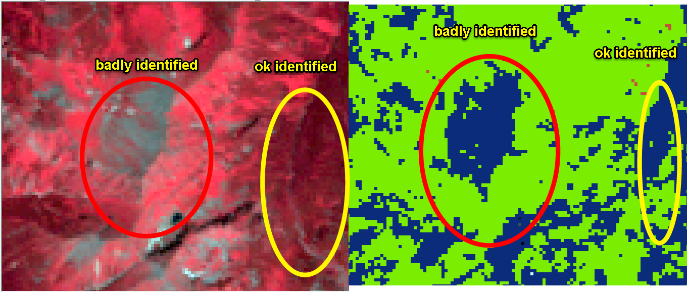
Unfortunately I didn´t find satisfactory results in my northern slopes and mouintainous area neither using DN values, neither using reflectance values downloaded from GLS surface reflectance as shown here: enter image description here

I suppose that the missing topographic normalisation of my data will be crucial for forest casstification on the northern slopes.

In this reason I suppose that calculation of Forest index doesn´t seem to be really helpful. I advise you to try another approach described in Meddens, A. J. H., Hicke, J. A., Vierling, L. A., & Hudak, A. T. (2013). Evaluating methods to detect bark beetle-caused tree mortality using single-date and multi-date Landsat imagery. Remote Sensing of Environment, 132, 49–58. doi:10.1016/j.rse.2013.01.002 in part 2.4 Single date and 2.5 Multidate classification (p. 52) meddens approach to identify forest cover

2

I have found this scientific article for forest/non-forest mapping using Landsat but unfortunately it is not free to read (15 $).

Wentao Ye; Xi Li; Xiaoling Chen and Guo Zhang

A spectral index for highlighting forest cover from remotely sensed imagery", Proc. SPIE 9260, Land Surface Remote Sensing II, 92601L (November 8, 2014); doi:10.1117/12.2068775

Here is annotation quote:

The FI (forest index) is derived from three bands, green, red and near-infrared (NIR) bands and an FI image can be classified into forest/non-forest map with a threshold. The overall accuracies of classification maps in the two study areas were 97.8% and 96.2%, respectively, which indicates that the FI is efficient at highlighting forest cover.

Unfortunately I can't access this article so not sure if this index works so well. My own tries to reproduce this index using specified bands are failed. I send a mail to the authors with a request to send this article but still no answer received.

UPDATE

Here is a paper: link

2
  • Thanks Mr. Che, it look good.I will also contact them because neither I have the free access to this publication... As soon as I´ll get it, I will send it to you.
    – maycca
    Commented Jan 20, 2015 at 14:43
  • I have found a paper! URL is in the answer's update. Commented Jan 27, 2015 at 9:18

Your Answer

By clicking “Post Your Answer”, you agree to our terms of service and acknowledge you have read our privacy policy.

Not the answer you're looking for? Browse other questions tagged or ask your own question.