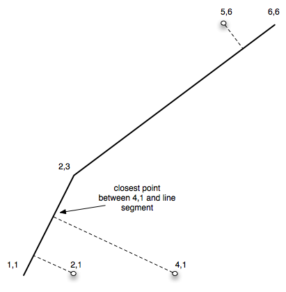
I'm developing a reverse-geocoder for Canada. So far, given a lat/lng, I can find the nearest street (line segment), which includes line segment direction and address ranges for both sides of the street. I'm now trying to figure out the best way to programmatically approximate the nearest house number to the given lat/lng point.
Here's an example of a row containing the street data:
-[ RECORD 1 ]-
[...]
l_adddirfg | Same Direction
l_hnumf    | 3219
l_hnuml    | 3235
l_stname_c | Breen Road North-west
r_adddirfg | Same Direction
r_hnumf    | 3224
r_hnuml    | 3236
r_stname_c | Breen Road North-west
the_geom   | 0105000020E610000001000000010200000002000000B0F6990E78885CC088DF2B5F3C8C49400875B39A89885CC0A0BCA6AC4B8C4940
So, given a lat/lng coordinate that lies near the "the_geom" line segment, a person could tell visually which side of the street the point is on (left or right side), and how far along the segment it is -- thereby approximating a house number. For example, if the point lies on the right side, three-quarters down the street, I would use the fields r_hnumf (right side, first number) and r_hnuml (right side, last number)... The street address is probably close to:
3232 Breen Road North-west
What I'm looking for is a best practice in either computing/approximating this in PostGIS (which I'm new to), or in the application layer once the row is fetched.
Thanks!

