4

For my work I want to print a road map of Mallorca on A0 size. Therefore it is important that the base file is a vector file. After doing some research I found that I should be able to open OpenStreetMap data in QGIS and from there to export a CSF or PDF file. But so far I have only just been able to open the OpenStreetMap in QGIS.

Which plugin should I use to select only part of the osm data and how can I export the selected part?

3
  • 1
    One way would be exporting the road data in OSM data from overpass-turbo.eu . Here you may use the wizard to build the query and run it. In your case highway=* and type:way will work. You can export the output in geojson format and then open it in QGIS.
    – poshan
    Commented Sep 24, 2016 at 13:39
  • Do I understand you correctly that the issue is how to render the data in an appropriate way?
    – underdark
    Commented Sep 24, 2016 at 13:43
  • Hey,The only thing i want is a map (picture) with al the streets of Mallorca. It must be a vector of pdf format to printed ans zoomed on a large papier. Commented Sep 26, 2016 at 13:08

2 Answers 2

3

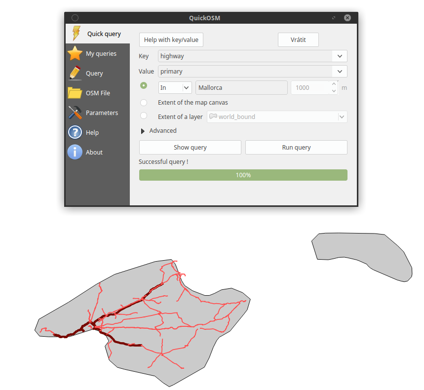
To get OSM data via Overpass-API (as @poshan mentioned in comment) you can use plugin called QuickOSM. Simplest way is using Quick query tab - choose Key and Value and set a location of required data (see image example) and hit Run query. List of OSM features with their keys and values is on the OpenStreetMap Wiki.

enter image description here

Other plugin you can use to get OSM data is OSMDownloader wich download all OSM data in given area, or you can download some prepared dataset (for example from geofabrik)


Edit:

Exporting:

Create a map layout output with print composer (File -> New Print Composer), add a map item and export as PDF. See documentation for print composer.

4
  • And how can i export this data to a pdf-file? Commented Sep 26, 2016 at 13:51
  • Create a map layout output with print composer (File -> New Print Composer), add a a map item and export as PDF. See documentation for print composer
    – Oto Kaláb
    Commented Sep 26, 2016 at 14:11
  • i did it like that but the quality of the text (the names of the cities) isn't good on a large paper. have you a solution for that? Commented Sep 26, 2016 at 14:39
  • If you mean labels, then try set text size units in label properties to Map units and then adjust font size you want.
    – Oto Kaláb
    Commented Sep 26, 2016 at 18:44
1

Your task - if I understand it correctly - has three parts:

(Forgive me if I misunderstand your level of knowledge - I'm hoping this answer may be at the level you need, and if it isn't your subsequent questions may help people to understand what you are struggling with - note also my alternative answer at the bottom of this text)

1) Get data from OSM

You want to fetch data from the Openstreetmap database. There are a number of ways to do this. It's relatively simple to do - start with a careful search of this site or just use Google.

When you do this the data may end up on your local machine in a number of different formats - stored in a number of different ways (relevant below). (Data may be stored in a database, as shapefiles, and so on)

2) Style the data

The data you get from OSM is plain simple geographical GIS data. It'll record, for example, that there is a road or a patch of grass. It doesn't say that grass should be green or that a road should be drawn 3mm wide. You need to style the data how you want it (green grass etc).

This task is NOT simple. Depending on what you want your map to show it could be extremely complex. You should look for existing styles that people have put up on the internet, but these may not look how you want.

What also makes things even more complex is that other people's styles tend to work on only one of the formats I mentioned in point 1 (at least in simple terms anyway).

3) You need to export/print the finished map to pdf

This is a relatively trivial step if you've got the other things sorted. You can use the tools in the QGIS print composer (or 'print' to pdf).

BUT you may want to consider other options. A key option is to use the export option from www.openstreetmap.org - which is limited but effective. Look for the share button at the right of the map. Make sure that you are on the standard rendering of the map (not the cycle rendering or whatever). There's an option to export as pdf or svg - b0th vector formats. Which you choose may depend how you are going to handle the vector image afterwards.

Your Answer

By clicking “Post Your Answer”, you agree to our terms of service and acknowledge you have read our privacy policy.

Not the answer you're looking for? Browse other questions tagged or ask your own question.