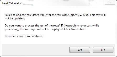
I am receiving an error when I try to calculate X/Y coordinates, and I cannot understand why the process is not working. I am working with a point feature class in an SDE database. The point feature class has about 3,255 records. Within the point feature class I have two fields to represent the X coordinate and the Y coordinate. Both of these fields are a double field type with precision 9 and scale 5. Both fields are set to allow NULL values, and no domains are assigned.
When I go to calculate geometry I choose the coordinate, use the current data projection, and select US feet. Everything up to this point seems fine, however, as soon as I initiate the calculation, ArcMap kicks back the following error:
In this case, the feature with Object ID of 3256 is the first record in the feature class. If I select yes then I get this error message:
Any ideas as to why this is happening? Am I using the wrong field type or do I have the wrong precision/scale for the double fielt type?


