I currently working on the data set "Wolfcamp Aquifer", but the coordinates in the data set is just a relative coordinates. So, is there anyone who has the original coordinates?
-
You may have to look into the sources given in wiki.stat.ucla.edu/socr/index.php/SOCR_061708_NC_Data_Aquifer– AndreJCommented Apr 15, 2018 at 6:11
-
Thank you so much. I check the link and the reference but, unfortunately, it's still the relatively coordinates. I was wondering how can I get the exact coordinates if I randomly assign a reference point to the relative coordinates.– NicolasCommented Apr 15, 2018 at 15:26
-
You would need the exact coordinates of the reference point to create a custom CRS like in gis.stackexchange.com/questions/83861/… . Note that map units have to be kilometers.– AndreJCommented Apr 15, 2018 at 16:55
-
If you want to type in (or image-to-text) the numbers, they are in the appendix of this PDF: researchgate.net/publication/…– SpacedmanCommented Apr 15, 2018 at 19:19
-
I've OCRd and fixed it up: gitlab.com/snippets/1710174– SpacedmanCommented Apr 15, 2018 at 20:13
1 Answer
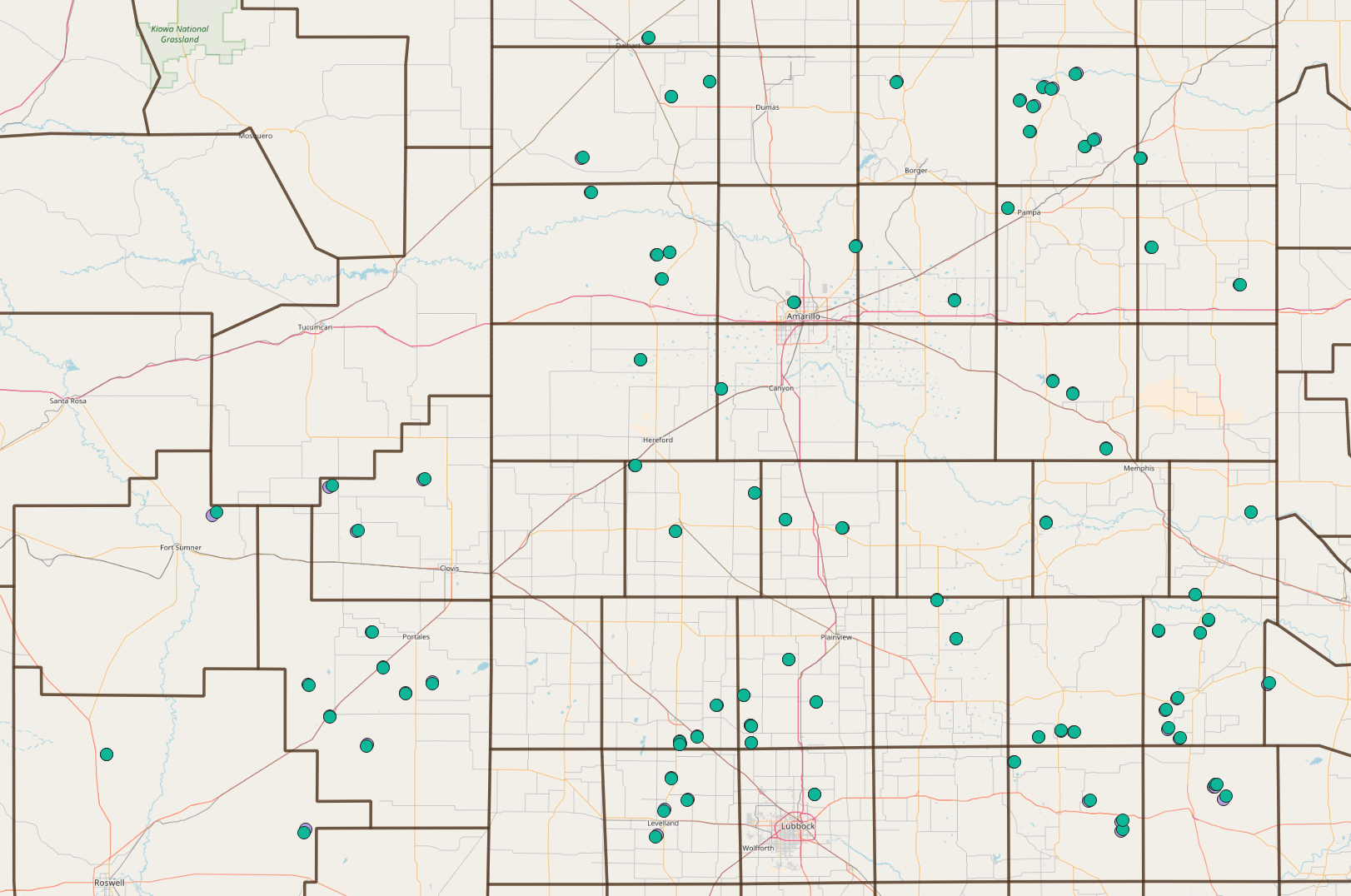
I found a map of the locations in an ICOTS8 (2010) Invited Paper by Harper & Clark called "AMARILLO BY MORNING: DATA VISUALIZATION IN GEOSTATISTICS" - you can probably search online and find this. I extracted the image, and georeferenced it in QGIS.
Then I identified a few of the sample locations on the map and got their lat-long coordinates. I then matched those up to the "relative" coordinates from the data set in R. So now I have a table of:
x_lat y_lat x_relative y_relative
coordinates for seven of the points. I can then run ogr2ogr on the command line using the coordinate pairs as control points - it looks like this:
ogr2ogr \
 -tps \
 -gcp  -233.72172 -115.83894 -11636657   4003094 \
 -gcp -30.54492  115.72629 -11392916   4286809 \
 -gcp   133.79896   95.12698 -11190784   4260256 \
 -gcp   174.71182  -27.48198 -11143259   4107547 \
 -gcp   18.74859 -130.78953 -11331381   3985634 \
 -gcp   -29.96271  -37.89631 -11391316   4099389 \
 -gcp  169.09138   51.54656 -11147872   4205489 \
 -f "ESRI shapefile" wcreftps.shp wc.shp
On each gcp option, the first two numbers are the "relative" coordinates, and the second two are in EPSG:3857 (Google Mercator). wc.shp is the R data saved to a shapefile.
After running this, the shapefile wcreftps.shp seems geolocated correctly - here it is with an OpenStreetMap and county boundaries.
The coordinates, in the same order as the 85 coordinates in the wolfcamp object in the R geoR package, are in this pastebin:
Caveat: These coordinates are as precise as my clicking on the map - they are not the original measured coordinates but should be close enough for most purposes that use the whole map - don't zoom in on one point and expect to see the exact location.
-
Wow...................Thank you so much .............It's amazing..I'm new to this field, your answer is really helpful.– NicolasCommented Apr 15, 2018 at 22:06
-
-
I may try and compare the coordinates I got from this with the ones I got from the original paper (linked in my comment to the question). Commented Apr 16, 2018 at 7:23
-
I think they didn't give the exact coordinates in their original paper, right?– NicolasCommented Apr 16, 2018 at 19:38
-
The paper I link in the comments gives both lat-long and offset-in-miles from a point coordinates. I'm not sure how "exact" these coordinates are, plus the lat-long appear to be in a 1958 military coordinate system and I can't find the technical manual online so I don't exactly know the coordinate transform parameters to get from that to EPSG:4326. Commented Apr 16, 2018 at 20:44

