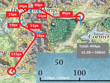
I have a fairly high resolution map (jpg, not vector), with a known scale. How to measure the length in pixels between multiple points on an image? For a straight line it is simple, but how to do it when there are multiple points / no straight lines? Is there a simple GIS tool that could do such a thing?
Example:
This can be reduced to 9 legs to get the total length in pixels.
I currently use the measure tool in Gimp, which allows for a maximum of two legs only. This gets tedious quickly (write down the pixels, and then sum the total later), when there are a lot of curves in a road.
Browsing through this Stack, I found QGIS, and installed it. I can import the map as a raster layer, but from that point on I'm not sure what to do. Can I overlay the map with points/lines somehow, to get distances?

