1

I run a query and I get a GeoJSON file, but when I try to load the file into the map, I get the error that it's an Unsuported GeoJSON type. this is the PHP file that generate GeoJSON :

$element = $_POST['element'];

$query = "SELECT one, two, three, ST_AsGeoJSON(geom, 7) AS geojson FROM TABLE WHERE parcel = '$parcel'";

$result = pg_query($query) or die('Query failed: ' . pg_last_error());

$geojson = array(
    'type' => 'FeatureCollection',
    'features' => array()
);
$i = 0;
while ($line = pg_fetch_assoc($result)) {
    $feature = array(
    'geometry' => json_decode($line['geojson'], true),
    'properties' => $data[]=$line,
    'id' => $i++
    );
    array_push($geojson['features'], $feature);
}
$localData = json_encode($geojson);

//$contData = "data/fileData_".session_id().".json";
$contData = "data/fileData.json";

$file = fopen($contData, "w");

fwrite($file, $localData);
fclose($file);

and the file is like this:

{
  "type": "FeatureCollection",
  "features": [
    {
      "geometry": {
        "type": "MultiPolygon",
        "crs": {
          "type": "name",
          "properties": {
            "name": "EPSG:25830"
          }
        },
        "coordinates": [
          [
            [
              [
                628354.2325,
                4630884.3655
              ],
              [
                628340.7125,
                4630906.3255
              ],
              [
                628344.293,
                4630942.2755
              ],
              [
                628344.673,
                4630946.0955
              ],
              [
                628352.403,
                4630943.3355
              ],
              [
                628378.293,
                4630938.4055
              ],
              [
                628427.4635,
                4630932.5155
              ],
              [
                628453.3535,
                4630928.2655
              ],
              [
                628536.7735,
                4630913.475
              ],
              [
                628555.6835,
                4630910.325
              ],
              [
                628556.4135,
                4630908.665
              ],
              [
                628557.2335,
                4630906.775
              ],
              [
                628559.8935,
                4630900.655
              ],
              [
                628562.8335,
                4630893.935
              ],
              [
                628565.553,
                4630884.025
              ],
              [
                628568.773,
                4630867.435
              ],
              [
                628571.8625,
                4630851.215
              ],
              [
                628578.6825,
                4630828.435
              ],
              [
                628586.3525,
                4630810.605
              ],
              [
                628580.442,
                4630804.225
              ],
              [
                628579.812,
                4630798.165
              ],
              [
                628575.472,
                4630792.465
              ],
              [
                628569.952,
                4630788.665
              ],
              [
                628555.922,
                4630778.625
              ],
              [
                628546.3315,
                4630771.655
              ],
              [
                628530.4115,
                4630760.435
              ],
              [
                628508.971,
                4630744.875
              ],
              [
                628505.081,
                4630743.235
              ],
              [
                628498.651,
                4630743.425
              ],
              [
                628492.501,
                4630743.695
              ],
              [
                628447.621,
                4630754.185
              ],
              [
                628434.221,
                4630756.635
              ],
              [
                628415.461,
                4630756.675
              ],
              [
                628398.861,
                4630751.805
              ],
              [
                628369.832,
                4630833.995
              ],
              [
                628369.122,
                4630836.275
              ],
              [
                628354.4225,
                4630883.7955
              ],
              [
                628354.2325,
                4630884.3655
              ]
            ]
          ]
        ]
      },
      "properties": {
        "id": "25",
        "cadastralcode": "50010A00700271",
        "parcel": "271",
        "zone": "300-400",
        "longitude": "41.819076014660794",
        "latitude": "-1.4532398649376337",
        "altitude": "364",
        "geojson": "{\"type\":\"MultiPolygon\",\"crs\":{\"type\":\"name\",\"properties\":{\"name\":\"EPSG:25830\"}},\"coordinates\":[[[[628354.2325,4630884.3655],[628340.7125,4630906.3255],[628344.293,4630942.2755],[628344.673,4630946.0955],[628352.403,4630943.3355],[628378.293,4630938.4055],[628427.4635,4630932.5155],[628453.3535,4630928.2655],[628536.7735,4630913.475],[628555.6835,4630910.325],[628556.4135,4630908.665],[628557.2335,4630906.775],[628559.8935,4630900.655],[628562.8335,4630893.935],[628565.553,4630884.025],[628568.773,4630867.435],[628571.8625,4630851.215],[628578.6825,4630828.435],[628586.3525,4630810.605],[628580.442,4630804.225],[628579.812,4630798.165],[628575.472,4630792.465],[628569.952,4630788.665],[628555.922,4630778.625],[628546.3315,4630771.655],[628530.4115,4630760.435],[628508.971,4630744.875],[628505.081,4630743.235],[628498.651,4630743.425],[628492.501,4630743.695],[628447.621,4630754.185],[628434.221,4630756.635],[628415.461,4630756.675],[628398.861,4630751.805],[628369.832,4630833.995],[628369.122,4630836.275],[628354.4225,4630883.7955],[628354.2325,4630884.3655]]]]}"
      },
      "id": 0
    }
  ]
}

I don't know what is the problem

1 Answer 1

4

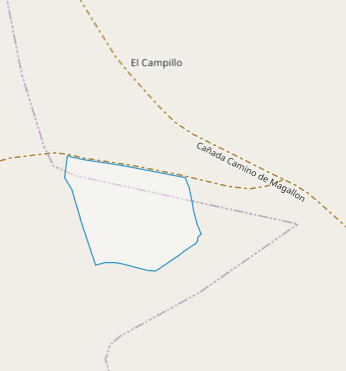
In creating your GeoJSON, you forgot to add type property for your feature: "type" : "Feature", so it should be:

{
  "type": "FeatureCollection",
  "features": [
    {
      "type": "Feature",
      "geometry": {
        "type": "MultiPolygon",
.
.
.

That's how it looks like then:

enter image description here

3
  • what do you use to see it? because it doesn't load it on the map for me. It doesn't give an error, but it doesn't load it on the map...
    – user68481
    Commented Jan 27, 2021 at 19:01
  • There is no code in your question of how you are trying to display it, so that's again new question. But one thing is for sure: since it's in EPSG:25830, you have to use proj4 to define projection and then use it when reading GeoJSON to convert coordinates to standard EPSG:3857.
    – TomazicM
    Commented Jan 27, 2021 at 19:37
  • See my modified answer to your original question: gis.stackexchange.com/questions/385490/…
    – TomazicM
    Commented Jan 27, 2021 at 20:13

Your Answer

By clicking “Post Your Answer”, you agree to our terms of service and acknowledge you have read our privacy policy.

Not the answer you're looking for? Browse other questions tagged or ask your own question.