1

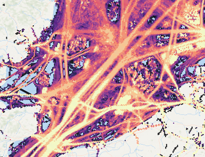
I've been working on creating a timeseries data aggregation of ocean vessel data. Things like the number of seconds that vessels spent in each grid cell per day, per vessel class, per navigation status etc etc.

Ship data

The typical way of publishing datasets at work is via geoserver but I'm concerned about some potential production concerns and I'm not too experienced with geoserver. Each aggregation has about 75k 1km^2 hexagon bins and is around 25 MB when saved as a csv.

enter image description here

I know that GeoServer has the ability to serve timeseries raster data but I'm not sure about vector data. Is there a similar tool for handling timeseries vector data?

Would it be better for me to first rasterize the data and serve that instead?

2
  • It is preferred if you can post separate questions instead of combining your questions into one. That way, it helps the people answering your question and also others hunting for at least one of your questions. Thanks!
    – Ian Turton
    Commented Oct 7, 2022 at 11:44
  • That makes sense. My question is limited to a single thing though; "Is there a method of handling time series vector data or is the only way to do this to first convert to raster?" But let me know if it needs further pruning
    – RedM
    Commented Oct 7, 2022 at 12:32

1 Answer 1

0

GeoServer supports time filtering on vector data too, you need:

  • To have a time values attached to each polygon in your dataset
  • Enable the time dimension in the layer

Since the dataset will have lots of entries, I'd suggest to store the data in a database (PostgreSQL/PostGIS), index on time, and possibly look into table partitioning.

Your Answer

By clicking “Post Your Answer”, you agree to our terms of service and acknowledge you have read our privacy policy.

Not the answer you're looking for? Browse other questions tagged or ask your own question.