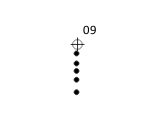
In QGIS 3.22.4, I've a WFS layer with measurements of soil-depths (LayerFrom & LayerTo) in the attribute table. With the symbology-geometry generator, I've created scalable circles (geometry type = polygon, unit = pixels) in the center of each layer, next to the coordinates of the measurements. The expression looks like this:
make_circle(make_point($x,$y+0.25*("LayerFrom"+(("LayerTo"-"LayerFrom")/2))),2.4)
where $x is calculated x-coordinate;
$y+0.25("LayerFrom"+(("LayerTo"-"LayerFrom")/2) is the y-coordinate with (pixel) offset based on depth
and 2.4 is the size of the created geometry.
For measurement '09', it gives the following result:
Now in QGIS 3.28.4 the points are set in the upper-left corner of the screen. I cannot figure out what changed and how to fix this. It seems like the coordinates are not calculated correctly/being ignored. Does anyone recognizes the problem?


make_circle((make_point($x,$y)),1)does give me points on the upper left corner. Furthermore I figured out that the problem is not in QGIS 3.24.0, but does occur in 3.26.0.