0

I want to have access to the vector shapes for site analysis from this site

https://maps.gsi.go.jp/vector/#15.958/35.136852/140.273124/&ls=vstd&disp=1&d=l

I would like to download or add into QGIS.

It allows me to download a .json file but it says Invalid Data Source when added into QGIS... Clearly, the map has vector shapes (like building parcels, train lines, etc) which I would like to be able to download to do a site analysis.

I have spent a while trying to understand this as I am new to QGIS. Can you provide a summary or explanation as to how I can or why I can't do it?

1
  • 1
    You probably need to share a sample file somewhere. The site is in Japanese so it's hard to know how to get a sample myself. Commented Mar 1 at 5:10

1 Answer 1

0

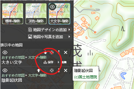
Is this the correct download button?

enter image description here

If so, the gsi-binarytile-style-1.json file that it downloads is not a valid GeoJSON file. It contains style information on how the vector data is displayed in the basemap, but not the vector data itself, so you won't be able to load it in QGIS.

It's possible the data is available elsewhere on the site, but it's also common that web maps allow you to view data but not download it.

1
  • 1
    Possibly vector tile data... Commented Mar 1 at 7:13

Your Answer

By clicking “Post Your Answer”, you agree to our terms of service and acknowledge you have read our privacy policy.

Not the answer you're looking for? Browse other questions tagged or ask your own question.