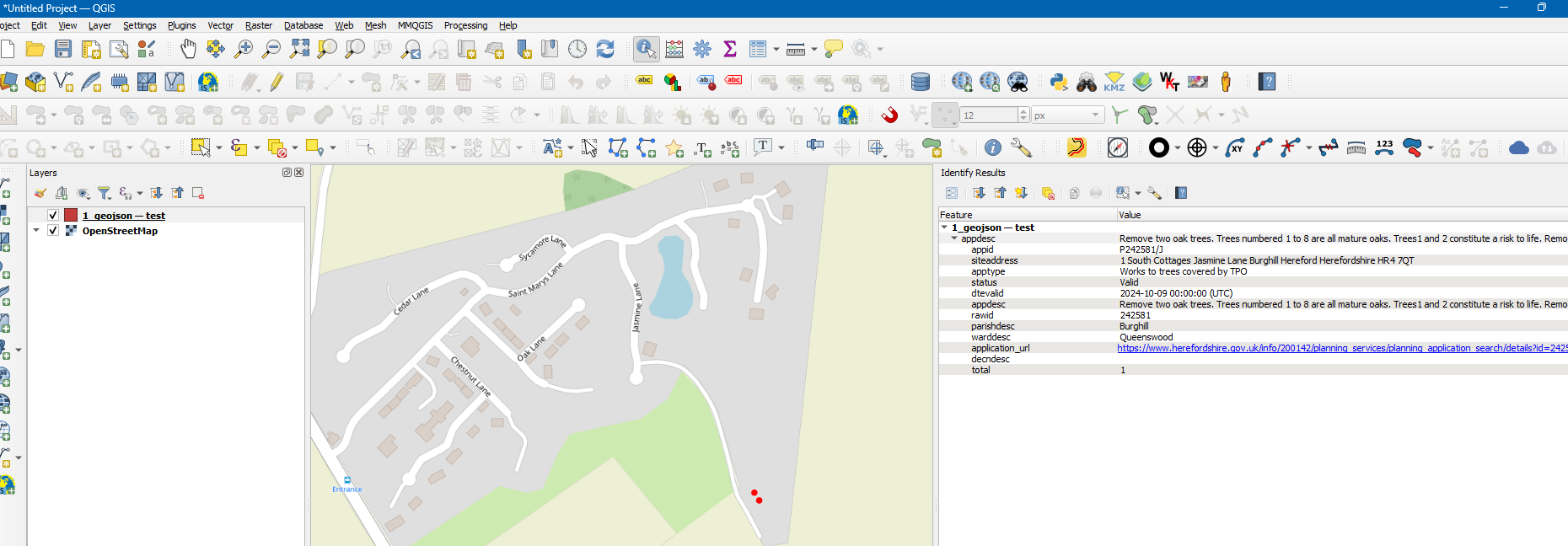
To get GeoJSON back for an application you need to request it.
(Random) Example:
https://restservices.herefordshire.gov.uk/planningV2/application/242581/geojson?callback=jQuery32107880159576218448_1729630488359&_=1729630488360
Which will return
jQuery32108695683097130928_1729630393698({"type":"Feature","geometry":{"type":"MultiPolygon","coordinates":[[[[-2.750844372,52.084684095],[-2.750844423,52.084683147],[-2.750844608,52.084682205],[-2.750844925,52.084681277],[-2.750845372,52.084680369],[-2.750845946,52.084679489],[-2.750846642,52.084678643],[-2.750847454,52.084677838],[-2.750848378,52.084677079],[-2.750849405,52.084676373],[-2.750850528,52.084675725],[-2.750851738,52.084675139],[-2.750853026,52.084674621],[-2.750854383,52.084674175],[-2.750855798,52.084673803],[-2.750857259,52.084673508],[-2.750858757,52.084673293],[-2.75086028,52.08467316],[-2.750861815,52.084673108],[-2.750863352,52.08467314],[-2.750864879,52.084673254],[-2.750866383,52.08467345],[-2.750867855,52.084673726],[-2.750869281,52.08467408],[-2.750870653,52.084674509],[-2.750871958,52.084675011],[-2.750873188,52.08467558],[-2.750874332,52.084676214],[-2.750875383,52.084676907],[-2.750876331,52.084677654],[-2.750877171,52.084678448],[-2.750877895,52.084679285],[-2.750878498,52.084680158],[-2.750878976,52.08468106],[-2.750879324,52.084681984],[-2.750879541,52.084682923],[-2.750879624,52.084683871],[-2.750879573,52.084684819],[-2.750879388,52.084685761],[-2.750879071,52.084686689],[-2.750878623,52.084687597],[-2.75087805,52.084688477],[-2.750877354,52.084689323],[-2.750876541,52.084690128],[-2.750875617,52.084690887],[-2.75087459,52.084691593],[-2.750873467,52.084692241],[-2.750872257,52.084692826],[-2.750870969,52.084693344],[-2.750869612,52.084693791],[-2.750868198,52.084694163],[-2.750866736,52.084694458],[-2.750865238,52.084694673],[-2.750863716,52.084694806],[-2.75086218,52.084694857],[-2.750860643,52.084694826],[-2.750859117,52.084694712],[-2.750857612,52.084694516],[-2.750856141,52.08469424],[-2.750854714,52.084693886],[-2.750853343,52.084693457],[-2.750852037,52.084692955],[-2.750850808,52.084692385],[-2.750849663,52.084691752],[-2.750848613,52.084691059],[-2.750847664,52.084690312],[-2.750846824,52.084689517],[-2.7508461,52.08468868],[-2.750845497,52.084687808],[-2.750845019,52.084686906],[-2.750844671,52.084685982],[-2.750844455,52.084685043],[-2.750844372,52.084684095]]],[[[-2.750917885,52.084755352],[-2.750917934,52.084754451],[-2.75091811,52.084753556],[-2.750918412,52.084752674],[-2.750918838,52.084751811],[-2.750919384,52.084750975],[-2.750920047,52.08475017],[-2.750920821,52.084749405],[-2.7509217,52.084748684],[-2.750922678,52.084748013],[-2.750923748,52.084747397],[-2.7509249,52.084746841],[-2.750926127,52.084746348],[-2.750927419,52.084745924],[-2.750928766,52.08474557],[-2.750930157,52.08474529],[-2.750931584,52.084745086],[-2.750933033,52.084744959],[-2.750934496,52.08474491],[-2.750935959,52.08474494],[-2.750937413,52.084745049],[-2.750938846,52.084745235],[-2.750940247,52.084745497],[-2.750941605,52.084745833],[-2.750942911,52.084746241],[-2.750944154,52.084746718],[-2.750945325,52.084747259],[-2.750946414,52.084747862],[-2.750947415,52.08474852],[-2.750948318,52.08474923],[-2.750949118,52.084749985],[-2.750949807,52.084750781],[-2.750950382,52.08475161],[-2.750950836,52.084752467],[-2.750951168,52.084753345],[-2.750951374,52.084754238],[-2.750951453,52.084755139],[-2.750951404,52.08475604],[-2.750951228,52.084756935],[-2.750950926,52.084757817],[-2.7509505,52.08475868],[-2.750949954,52.084759516],[-2.750949291,52.08476032],[-2.750948517,52.084761086],[-2.750947638,52.084761807],[-2.75094666,52.084762478],[-2.750945591,52.084763094],[-2.750944438,52.08476365],[-2.750943211,52.084764143],[-2.75094192,52.084764567],[-2.750940573,52.084764921],[-2.750939181,52.084765201],[-2.750937755,52.084765405],[-2.750936305,52.084765532],[-2.750934843,52.084765581],[-2.750933379,52.084765551],[-2.750931925,52.084765442],[-2.750930493,52.084765256],[-2.750929092,52.084764994],[-2.750927733,52.084764658],[-2.750926427,52.08476425],[-2.750925184,52.084763773],[-2.750924013,52.084763232],[-2.750922924,52.084762629],[-2.750921923,52.084761971],[-2.75092102,52.084761261],[-2.750920221,52.084760506],[-2.750919531,52.08475971],[-2.750918957,52.084758881],[-2.750918502,52.084758024],[-2.75091817,52.084757146],[-2.750917964,52.084756253],[-2.750917885,52.084755352]]]]},"properties":{"appid":"P242581/J","siteaddress":"1 South Cottages Jasmine Lane Burghill Hereford Herefordshire HR4 7QT","apptype":"Works to trees covered by TPO","status":"Valid","dtevalid":"2024-10-09T00:00:00.000Z","appdesc":"Remove two oak trees. Trees numbered 1 to 8 are all mature oaks. Trees1 and 2 constitute a risk to life. Removal of these trees would lessenthe immediate danger to anyone in the cottage or in the gardens, and provide more light to the gardens whilst the amenity value would be unaffected as there would still be six oaks in the garden. No works totrees 3 - 8.\r","rawid":"242581","parishdesc":"Burghill","warddesc":"Queenswood","application_url":"https://www.herefordshire.gov.uk/info/200142/planning_services/planning_application_search/details?id=242581","decndesc":"","total":1}})
This can be loaded into QGIS (3.38 used)


download the results as CSV files. Then import the data into QGIS as a CSV layers (see tutorials/GIS SE questions for that)