11

I'm a bit new to the whole GIS world, and though I am making great headway drawing polygons and such in Bing Maps, I am currently stuck. In our SQL spatial data, I came across MULTIPOLYGON data, where all the coordinate values are very large numbers (6 digits and 7 digits for what should be latitude and longitude, before the decimal). I found an SQL method to dismantle the multi-polygon into several polygons, but those large values do not work in Bing Maps nor Google Maps. So I've been searching for an algorithm to convert those large numbers down to what I have perceived as regular latitude/longitude numbers, such as 45.19167 -93.58328 (which does work on online maps).

With that said, could somebody please either show me or point me in a great direction to learning how to convert 631456.83, 3816200.79 to something I can use online. I know the coordinates fall somewhere in Arizona.

5
  • 2
    You need to convert that data from one coordinate system to another. Don't use an algorithm, use a library. Or a GIS desktop application. Or OGR. alastaira.wordpress.com/ogr2ogr-patterns-for-sql-server
    – Alex Leith
    Commented Dec 12, 2013 at 23:07
  • 3
    Please update the question with the location of your data / sample point (city, county, etc). As @radar implies, your data is in a projected, rather than geographic, coordinate reference system. It may be UTM, but could be something else. Knowing where the data is will allow someone to figure out which UTM zone, or if there's another possible ProjCRS.
    – mkennedy
    Commented Dec 12, 2013 at 23:18
  • 1
    Duplicated question on SO (with a sample polygon): stackoverflow.com/q/20552567 Commented Dec 13, 2013 at 10:36
  • I didn't realize this site existed until I posted on StackOverflow and got all kinds of responses from people seemingly as confused as I was. :-) Commented Dec 13, 2013 at 14:35
  • There's some confusion here because you appear to have mixed up the meanings of latitude and longitude.
    – whuber
    Commented Dec 13, 2013 at 16:22

2 Answers 2

11

Your coordinates are likely in UTM (Universal Transverse Mercator) Eastings and Northings.

You can convert UTM coordinates to lat/long online using many different sites. Here in one. You can also perform this calculation in excel or inside of a database if you can work out the formula. Alternatively you can perform the conversion inside of a GIS such as QGIS or ArcGIS.

Before you can convert coordinates to lat/long you will need to know which UTM zone your coordinates fall in.

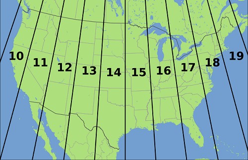
Here is an example for North America:

enter image description here

In this example, most of Florida falls within the UTM zone 17N.

I came across this page by searching 'batch convert UTM to lat/long'.

5
  • 3
    If latitude has six digits and longitude seven, it's almost certainly not a UTM coordinate.
    – whuber
    Commented Dec 13, 2013 at 1:07
  • 1
    UTM Zones are but some of many Projected Coordinate Systems so the asker may need to research which one has been used if a simple inversion of his X and Y does not start to make UTM sense.
    – PolyGeo
    Commented Dec 13, 2013 at 4:50
  • The company I work for has been using a 3rd party application to process display their GIS, but the application is terribly slow and outdated, and I am tasked with seeing if a custom solution can be developed to display these GIS maps on Bing Maps, as part of our online service. I do know that all coordinates are within the bounds of the USA. Commented Dec 13, 2013 at 14:43
  • I do know what State and County the coordinates fall into, along with how many total acres, along with fields I presume to be FarmNumber and TractNumber. Hopefully with this data I can determine the Zone. Commented Dec 13, 2013 at 14:52
  • Radar, that put me into the correct state. Thanks a bunch for explaining this to me. Now I need to figure out a way of dynamically determining Zones, based off State/County pairs...but that sounds like fun. Commented Dec 13, 2013 at 16:20
9

Try this one:

http://cs2cs.mygeodata.eu/

or use "proj" (command line below assuming UTM zone 17 south and wgs84):

# geographical coordinates (ie. longitude,latitude) to utm
proj -f "%.4f" +proj=utm +zone=17 +south +ellps=WGS84 < myfile

# utm to geographical coordinates (ie. longitude,latitude)
proj -f "%.4f" +proj=utm +zone=17 +south +ellps=WGS84 -I < my file

In your case (ie, 631456.83356859628, 3816200.7961099017; which are Easting and Northing UTM coordinates respectively as METERS) you need to know the utm ZONE and HEMISPHERE (something like ZONE 17 SOUTH above). Your data should likely be in WGS84.

In the end if you don't know the UTM zone you are, I would simply loop over the USA UTM zones (ie. 10-19) to get the geographical coordinates, and then plot the resulting coordinates to see which are the correct ones:

for ((utmZone=10;utmZone<20;utmZone++))
do
  echo 631456.83356859628 3816200.7961099017 | proj -f "%.4f" +proj=utm +zone=$utmZone +north +ellps=WGS84 -I
done

getting:

-121.5685       34.4790
-115.5685       34.4790
-109.5685       34.4790
-103.5685       34.4790
-97.5685        34.4790
-91.5685        34.4790
-85.5685        34.4790
-79.5685        34.4790
-73.5685        34.4790
-67.5685        34.4790

where "%.4f" controls the number of decimals.

Hope this helps,

1
  • If the location is in Arizona then the UTM zone is 12 north , not 17 south.
    – Hans Erren
    Commented Apr 1, 2021 at 9:48

Your Answer

By clicking “Post Your Answer”, you agree to our terms of service and acknowledge you have read our privacy policy.

Not the answer you're looking for? Browse other questions tagged or ask your own question.