2

Here is the problem I am facing. After geocoding some addresses, I used the "point to line" tool. Some long streets with minimal matching address points created long lines that intersect the road layer. What I need is for the dark blue line to "snap" as close as possible to the light blue road layer.

What I've tried: Densifying the dark blue line and then edge-snapping to the roads layer. The line then snaps to the wrong road sometimes. The vertices of the dark blue line are the points that matched to the light blue line.

Is there anyway I can give the "points to line" result the same street name and then snap to the matching street?

Using ArcMap Desktop Advanced 10.2.
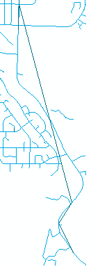
enter image description here

6
  • Can you add an example where your point to line is really usefull, because here I would simply suggest to remove the dark blue line.
    – radouxju
    Commented Dec 26, 2013 at 20:32
  • The "point to line" data comes from geocoded address points that contain +4 ZIP info. The road layer does not. The dark blue line has all the attributes I need. The completed task would be to have +4 ZIP data associated with each street. This is for Guam
    – Maksim
    Commented Dec 26, 2013 at 20:36
  • I guess i'm looking for a tool that would snap to a road name, versus a distance. If one exists, or if something like that is even possible
    – Maksim
    Commented Dec 26, 2013 at 20:37
  • there is no tool to do this automatically in ArcGIS. Of course, spatial join could help to add your +4 ZIP data, but you would not get it for all line segments. Open Jump could help a little bit (but still with manual work)
    – radouxju
    Commented Dec 26, 2013 at 21:01
  • Yea i'm guessing ill run the snap tool with a small tolerance to get most of the data correct, and then just "align to edge" the remaining lines that are too far away.
    – Maksim
    Commented Dec 26, 2013 at 21:06

1 Answer 1

1

As far as I know, there is no tool to do this automatically in ArcGIS. Of course, spatial join could help to add your +4 ZIP data, but you would not get it for all line segments. The problem is that your lines are quite far from each otherin some places, so that defining an automated rule would not match a trained user. One solution to help identifying the good street would be to filter the light blue based on some attributes (e.g. only keep main roads or iteratively select the road with matching names, one by one in a loop)

Open Jump is an open source solution with more conflation tools than ArcGIS, but in any case you still need manual work.

Your Answer

By clicking “Post Your Answer”, you agree to our terms of service and acknowledge you have read our privacy policy.

Not the answer you're looking for? Browse other questions tagged or ask your own question.