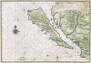
In this old map of California you will notice a ring of intersection points, all circling the focal land mass of the map. What are these intersections used for? I assume they are meant to guide the cartographer, but how do they work? What determines how the intersections of lines are placed?
-
Ha, I almost added that question to this one. Almost a duplicate, but not quite. I want to know how they work.– StuCommented Jun 11, 2014 at 20:14
-
I agree--the apparent dup is close, but it focuses on knowing a name for such maps but does not go very far towards answering the interesting questions, such as (-) why were the stars placed where they were? (-) Were the lines used for map construction as well as navigation (recent research suggests yes)? (-) Are the lines reasonable approximations to true lines of constant bearing (loxodromes)? (-) How exactly would one use them to aid navigation? (-) Why do the lines extend inland if they are solely intended as navigational aids? (-) Why are the radial lines around some stars incomplete?– whuberCommented Jun 11, 2014 at 21:11
-
Some beautiful examples that inspired these questions can be found at a Yale library site.– whuberCommented Jun 11, 2014 at 21:13
-
Possible duplicate of Is There A Term For The Old Maps That Had Lines Connecting Pin-Wheels?– NakilonCommented Mar 24, 2018 at 10:12
2 Answers
These are a component of Portolan Charts and they represent the compass directions. In this specific map, I'm assuming they're just there for style since this isn't an accurate enough map for true navigation.
I don't actually know this to be the intended purpose, but to me, from just a visual inspection, it looks like it would be primarily an angle measurement tool. If you notice, the point at the center of the map has lines coming off of it at different angles, primarily one lines going North, North North East, North East, East North East, East, East South East, etc... all the way around the center of the map in a compass rose type fashion. If you follow these lines out, each of them connect to one of the intersection points you are seeing in a ring around the map. Similarly, it looks like each of these intersection points have all of those same lines drawn from them in the same directions, which is evidenced if you look at the compass rose on the left side of the map. I don't know exactly how these would have been used in their time, but my guess would be that it would help in measuring distance through some calculations as well as the obvious assistance in measuring angle/direction of the map. It also due to the E/W running lines and the N/S running lines creates a grid effect which may or may not have been of some significance.
Again, I don't know why specifically these were put on there or what specifically they would have been used for, but as to what governs where they were placed, it at least appears like it is all basically a big compass rose of compass roses... just my observations. Hope that helps.
-
1Yes, that does help. Can't quite accept as the answer, but useful. I also wonder what governs the "radius" of the ring of compass roses.– StuCommented Jun 11, 2014 at 20:13
-
1@Stu At least in the case of the example map you provide an image of, it appears to simply be a matter of the ring being the size of the map itself. The northern and southern most intersection points appear to be at the edge of the map, and the rest in a circle, so it would suggest that the basis of the ring's radius is the size of the map it self. However, it is always possible that it in some way corresponds to some understanding of latitude/longitude, projections, etc... as well. Otherwise, another possibility might be some correspondence to scale/measurements, but that's all guesses.– JohnCommented Jun 11, 2014 at 21:29