2

I have lines of points that I'd like to connect to create individual polygons. The Minimum Bounding Geometry tool is great because it lets me input many points at once and use the "Group" option to create separate polygons. However, the Convex Hull option isn't accurate enough in drawing some of these boundaries. See:
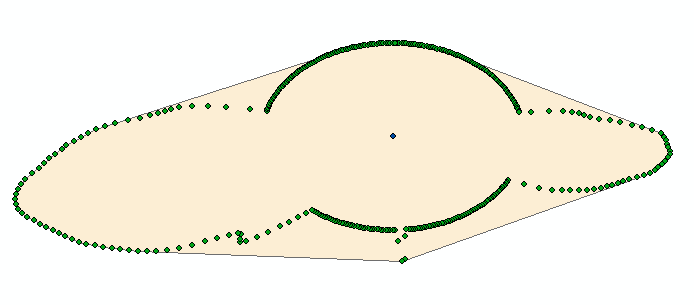
enter image description here I am looking for an alternative way to turn many points into polygons. Data looks something like this:

Ax1   Ay1   A
Ax2   Ay2   A
...   ...   ...
Bx1   By1   B    
...   ...   ...

These points are listed in a particular order, so a Point --> Line --> Feature task would work. I am just looking for an easier way.

6
  • What do you mean by "Convex Hull algorithm isn't accurate enough in drawing some of these boundaries"? Convex Hull doesn't take into consideration resultant overlapping features. The points are processed in groups independently. Commented Mar 29, 2016 at 14:54
  • For some of the more jagged groups of points (see updated picture), convex hull doesn't capture the details of their boundary. Does this answer your question? I'm looking for a method that is simple like MBG (and has a Group option or equivalent) but makes polygon boundaries that are more true to the point placements. In other words, I'm looking for a better method for creating polygons groups of points. Convex hull does the job for some groups and not for others Commented Mar 29, 2016 at 14:59
  • Does ArcMap have ConcaveHull?
    – user30184
    Commented Mar 29, 2016 at 15:09
  • @user30184 Thanks, great suggestion! ArcMap doesn't have this directly, but a brief internet search turned up with some plug-ins to explore. Do you know of an easy way to do Concave Hull outside of Arc, by chance? Commented Mar 29, 2016 at 15:18
  • gis.stackexchange.com/questions/150330/… for arcmap; github.com/mlaloux/Python--alpha-shape_concave_hull and gist.github.com/hellpanderrr/2c08af0f07eed4782234 for pure Python. It's also called alpha shape sometimes. Commented Mar 29, 2016 at 15:19

1 Answer 1

2

Concave hull did the trick, as many suggested. Specifically I used this Arc tool: https://geonet.esri.com/blogs/richard_fairhurst/2015/06/11/bruce-harolds-concave-hull-estimator-tool-enhanced .

Your Answer

By clicking “Post Your Answer”, you agree to our terms of service and acknowledge you have read our privacy policy.

Not the answer you're looking for? Browse other questions tagged or ask your own question.