15

I have downloaded a file showing the status of the National Broadband Network. The CSV file contains a field "Development Shape", which contains

"POLYGON ((153.101112401 -27.797998206, 153.097860177 -27.807122487, 153.097715464 -27.8163131, 153.100598081 -27.821068293, 153.103789404 -27.825046709, 153.106078824 -27.830224804, 153.108248251 -27.836106915, 153.110692137 -27.837863953, 153.116288014 -27.840655525, 153.119923205 -27.844817942, 153.122317372 -27.853523235, 153.127785181 -27.851776938, 153.131234286 -27.851150309, 153.135634115 -27.849740655, 153.138235543 -27.848667877, 153.141702556 -27.847075291, 153.152204703 -27.844959644, 153.15548911 -27.843380913, 153.158613317 -27.841545667, 153.161936609 -27.84058971, 153.156360679 -27.838491612, 153.15709719 -27.834509947, 153.150360063 -27.83270459, 153.151126372 -27.827536316, 153.151689864 -27.822563851, 153.14849171 -27.820801492, 153.148374771 -27.817968784, 153.139018666 -27.81580407, 153.139814105 -27.808556369, 153.126485712 -27.805759965, 153.124678962 -27.803584281, 153.120764096 -27.80295276, 153.121396647 -27.797353389, 153.100468927 -27.793620173, 153.09982846 -27.793327332, 153.101112401 -27.797998206))".

This is just for one entry. Is it possible to map this in QGIS?

2 Answers 2

19

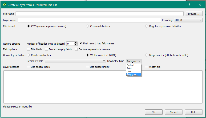
Go to Layer -> Add Layer -> Add Delimited Text Layer. You should be able to find the csv file you have, give it a layer name, and choose file format as CSV.

In the Geometry Definition, you will have to use Well known Text (WKT) by ticking that box. Set the Geometry field to the column you want, and you might want to set the Geometry type as Polygon.

See below: enter image description here

For speed, you might want to tick the 'Use spatial index' box as well. Good luck :)

2
  • can you do this with python?
    – user32882
    Commented Sep 12, 2018 at 13:01
  • This just pulls my data in as a table and the data doesn't appear on the map? ...
    – Sam
    Commented Dec 17, 2019 at 3:04
8

If you add a header line with "wkt;" you can drag the file directly into QGIS canvas:

wkt;
POLYGON((...))

Instead of the semicolon you can also use a colon (,) or a tab.

2
  • 1
    after that, you should set CRS via right click on new layer -> properties -> settings
    – khaverim
    Commented Jul 6, 2022 at 13:48
  • @khaverim that‘s totally correct. Or you change your project CRS before importing the file, if the CRS of the file is different.
    – christoph
    Commented Jul 6, 2022 at 15:46

Your Answer

By clicking “Post Your Answer”, you agree to our terms of service and acknowledge you have read our privacy policy.

Not the answer you're looking for? Browse other questions tagged or ask your own question.