3

I've been tasked with finding a complete dataset of Scotland's electricity grid network. This comprises a series of cables carrying 132 to 400 kV. I'm assuming that many of these cables are above ground. The National Grid publish an open dataset of both cables and pylons for England and Wales. However the grid in Scotland is managed by Scottish and Southern Energy and Scottish Power, and neither publishes GIS data.

I've noticed that cables and pylons are shown on OpenStreetMap, but only draw when you zoom in beyond 1:10,000 or so. I don't understand the complexities of OSM enough to make the most of the tagging system, so I could well be missing something fundamentally important here. I downloaded the 'Scotland latest' dataset from Geofabrik but this seems to be generalised, and doesn't include the cables I need.

I have had moderate success in QGIS importing lines for a trial area using the Vector -> OpenStreetMap -> Download Data route. However I cannot download national coverage this way.

I've also installed Java OpenStreetMap Editor, on the back of information online that suggests you can use this to download data. Unfortunately I've not found a way to query data for download using tags and you cannot download national-scale datasets.

Rather than take a 'dump' of all OSM layers, I would quite like to be able to state the layers I require and, say, a bounding box for which I wish the data within.

Ultimately the grid would be used in ESRI ArcMap in a map for publication.

3
  • Be aware that OSM might not be complete! Commented Jul 28, 2016 at 9:44
  • 1
    Absolutely. I downloaded the railway dataset for Scotland and had a brief look at my native Edinburgh for reference. I was surprised to see sections of long-extinct suburban railway lines present within the data. Perhaps Network Rail still own the solum in these instances, but it could simply be the handiwork of somebody with an old street map of the city.
    – ABragg
    Commented Jul 28, 2016 at 11:02
  • 1
    Also be aware that the geofabrik shapefiles are extracts, there is not the whole attributes included! In QGIS you could use the pbf files I believe. Commented Jul 28, 2016 at 11:21

4 Answers 4

5

The osm tag you need for this is called power=line. You can obtain the data you're looking for on overpass-turbo. The query you need for this is

way
  [power=line]
  ({{bbox}});
(._;>;);
out;

Of course you can further modify it by adapting voltage=* for example.

2
  • Many thanks for this. I've run the query as per above, and it has warned me that the output is ~20 MB worth of data, and is still at the 'parsing data' stage. I will persevere with this for the time being.
    – ABragg
    Commented Jul 28, 2016 at 9:31
  • Note that there is also power=minor_line. However this tag is for lines with voltages <= 50 kV.
    – scai
    Commented Jul 28, 2016 at 9:37
4

There are lots of ways..

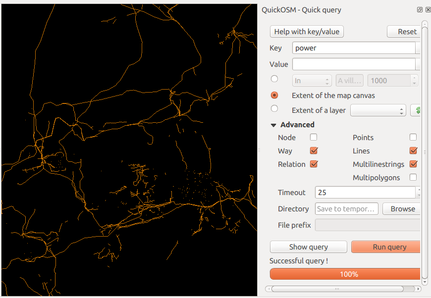
I think the easiest is probably the QuickOSM plugin for QGIS. This is a GUI wrapper around overpass turbo mentioned already. I personally find it's faster on my old laptop than using the overpass turbo website directly, but your mileage may vary. You can get back shapefiles or geojson using this plugin; the web site has more export options.

Just use the power as the key and leave the value option empty, and edit the timeout if the default 25 seconds is too low. (Tip: make sure you include Relations or you won't get much data back).

This is really just an alternate way of implementing karpfen's answer :-

enter image description here

If postgresql is an option for you, bringing the GeoFabrik pbf downloads into postgres with osm2pgsql is another way. As a bonus you effectively have all of OSM for Scotland, so if you need to start adding roads or place names (even if only to get some context) you have them to hand. I'm not sure how easy it is to get osm2pgsql working on Windows, though.

1
  • This worked like a charm. Once I got the data into QGIS I was able to export it as a .shp file and I can now see it in ArcMap on my desktop machine.
    – ABragg
    Commented Jul 29, 2016 at 10:19
3

Alternatively to osmfilter, you can use osmosis to extract the data from Geofabrik extracts in one step:

osmosis.bat --read-pbf <sourcefile>.osm.pbf --tf accept-ways power=* --tf accept-relations route=power --used-node --write-xml <outfile>.osm

You will get the fences around power substations and stations as well. To import the data into QGIS, you can use Add Vector layer, or Vector -> OpenStreetMap -> Import Topolgy from XML, then Export Topology to Spatialite.

2

Another way is to download the osm.pbf instead of the shape files from Geofabrik.

In this database, you will find the desired feature power=line. You can convert the .pbf to .osm (using Osmconvert: http://wiki.openstreetmap.org/wiki/Osmconvert) and filter the database (so you just get power lines) using OSMfilter (http://wiki.openstreetmap.org/wiki/Osmfilter, see wiki for the query).

Then load the lines via the QGIS dialogue vector --> OpenStreetMap--> import topology from xml etc.

Hope that works for you!

Your Answer

By clicking “Post Your Answer”, you agree to our terms of service and acknowledge you have read our privacy policy.

Not the answer you're looking for? Browse other questions tagged or ask your own question.