I'm trying to create a Web Map Context(WMC) file using OWSLib. WMC is supported, but there are no examples on any official pages: OWSLib 0.14.0 documentation, PyPI~ OWSLib 0.14.0, GitHib OWSLib examples.
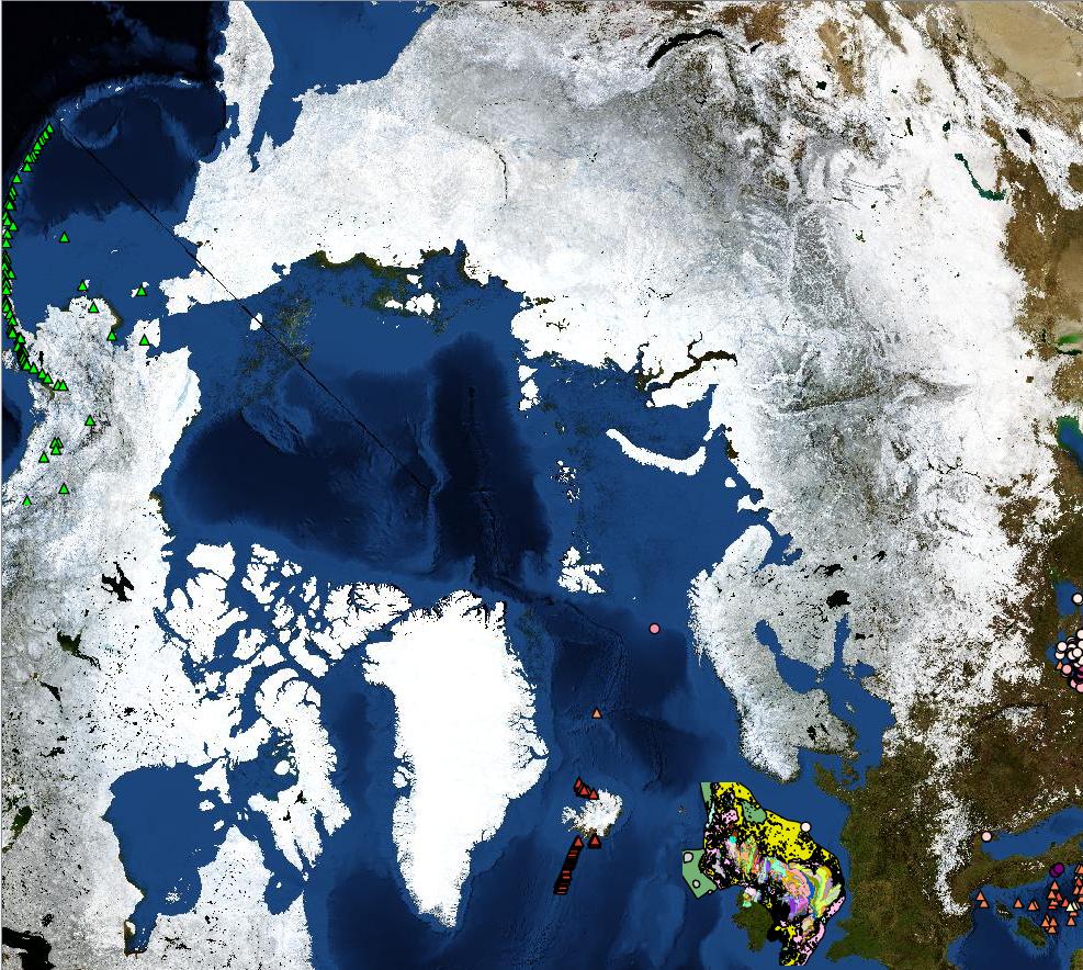
I have a client showing some WMS map layers:
There are six layers, from four different Web Map Services (WMS)
The WMS GetMap request for the base layer is:
One of the other layers (submarine volcanoes) is:
etc.
The context I am trying to create should look something like:
<?xml version="1.0" encoding="UTF-8"?>
<ViewContext version="1.1.0" id="some_unique_id1"
    xsi:schemaLocation="http://www.opengis.net/context http://schemas.opengis.net/context/1.1.0/context.xsd"
    xmlns="http://www.opengis.net/context" xmlns:xsi="http://www.w3.org/2001/XMLSchema-instance" xmlns:xlink="http://www.w3.org/1999/xlink">
    <General>
        <Window width="1205" height="735"/>
        <BoundingBox SRS="EPSG:3413" minx="-3571059.167819473" miny="-4645193.605181879" maxx="4940480.654283983" maxy="546492.5103750005"/>
        <Title>Cool maps</Title>
        <Abstract>A web map context showing some services that have NSIDC support</Abstract>
    </General>
    <LayerList>
        <!-- The specification says: 'The Layers are presented in a bottom to top approach.' -->
        <Layer queryable="1" hidden="0">
            <Server service="OGC:WMS" version="1.1.1" title="BGS_NASA_EN_BLUE_MARBLE">
                <OnlineResource xlink:type="simple" xlink:href="http://ogc2.bgs.ac.uk/geoserver/OneG/ows?"/>
            </Server>
            <Name>ARCTIC_NASA_BLUEMARBLE</Name>
            <Title>ARCTIC_NASA_BLUEMARBLE</Title>
            <Abstract>Blue Marble image (90 to 30 degrees North) for use as Arctic backdrop for the OneGeology portal. This backdrop is intended to be displayed in EPSG:3413 projection.</Abstract>
            <SRS>EPSG:3413</SRS>
            <FormatList>
                <Format>image/png</Format>
                <Format>image/geotiff</Format>
                <Format current="1">image/jpeg</Format>
                <Format>image/png; mode=8bit</Format>
            </FormatList>
            <StyleList>
                <Style current="1">
                    <Name/>
                    <Title>Default</Title>
                </Style>
            </StyleList>
        </Layer>
        <Layer />
        <Layer />
        <Layer />
        <Layer />
        <Layer />
    </LayerList>
</ViewContext>
wmc.py tells us that...
class MapContext: """ Map Context abstraction It uses a Map representation as input and export it as as map context
But I'm not sure what a Map representation is in this context.
I tried:
import owslib.wmc as wmc
context_for_basemap_map2 = wmc.mapToWebMapContext("http://ogc2.bgs.ac.uk/geoserver/OneG/wms?SERVICE=WMS&VERSION=1.1.1&REQUEST=GetMap&BBOX=-3475652.856302516069,-3703399.183262269478,5088484.602957472205,3983478.759379811119&SRS=EPSG:3413&WIDTH=986&HEIGHT=886&LAYERS=ARCTIC_NASA_BLUEMARBLE&STYLES=&FORMAT=image/jpeg&FORMAT_OPTIONS=dpi:96&ID=some_unique_id1&")
But I get error:
C:\Python36\python.exe E:/.../wmc-test.py
Traceback (most recent call last):
File "E:/.../wmc-test.py", line 65, in <module>
context_for_basemap_map2 = wmc.mapToWebMapContext("http://ogc2.bgs.ac.uk/geoserver/OneG/wms?SERVICE=WMS&VERSION=1.1.1&REQUEST=GetMap&BBOX=-3475652.856302516069,-3703399.183262269478,5088484.602957472205,3983478.759379811119&SRS=EPSG:3413&WIDTH=986&HEIGHT=886&LAYERS=ARCTIC_NASA_BLUEMARBLE&STYLES=&FORMAT=image/jpeg&FORMAT_OPTIONS=dpi:96&ID=some_unique_id1&")
File "C:\Python36\lib\site-packages\owslib\wmc.py", line 209, in mapToWebMapContext
return MapContext(map)()
File "C:\Python36\lib\site-packages\owslib\wmc.py", line 141, in __call__
wmc_doc_tree = self._getRootElement()
File "C:\Python36\lib\site-packages\owslib\wmc.py", line 47, in _getRootElement
'id' : self._map.id,
AttributeError: 'str' object has no attribute 'id'
I tried:
import owslib.wms as wms
import owslib.wmc as wmc
w = wms.WebMapService("http://ogc2.bgs.ac.uk/geoserver/OneG/ows?", version='1.1.1')
img = w.getmap(layers=["ARCTIC_NASA_BLUEMARBLE"], srs='EPSG:3413', bbox=(-3475652, -3703399, 5088484, 3983478), size=(986, 886), format='image/jpeg', transparent=False, method="Get", exceptions="application/vnd.ogc.se_xml", format_options="dpi:96", queryable="0", id="some_unique_id1")
context_for_basemap_map = wmc.mapToWebMapContext(img)
But I get error:
C:\Python36\python.exe E:/.../wmc-test.py
Traceback (most recent call last):
File "E:/.../wmc-test.py", line 49, in <module>
context_for_basemap_map = wmc.mapToWebMapContext(img)
File "C:\Python36\lib\site-packages\owslib\wmc.py", line 209, in mapToWebMapContext
return MapContext(map)()
File "C:\Python36\lib\site-packages\owslib\wmc.py", line 141, in __call__
wmc_doc_tree = self._getRootElement()
File "C:\Python36\lib\site-packages\owslib\wmc.py", line 47, in _getRootElement
'id' : self._map.id,
AttributeError: 'ResponseWrapper' object has no attribute 'id'
How do I create the context?

