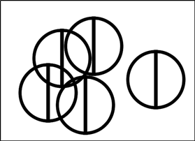
I have set up a map file on Ubuntu 16.04 with SVG symbols created by Inkscape. Everything is fine. Now I have to port it to a windows server. I installed MS4W, but layers with SVG symbols can't be rendered, the error message is:
[Thu Jan 04 10:08:39 2018].979000 msPreloadSVGSymbol(): Renderer error. problem parsing svg symbol
The MapServer version:
MapServer version 7.0.7 (MS4W 3.2.3) OUTPUT=PNG OUTPUT=JPEG OUTPUT=KML SUPPORTS=PROJ
SUPPORTS=AGG SUPPORTS=FREETYPE SUPPORTS=CAIRO SUPPORTS=SVG_SYMBOLS SUPPORTS=SVGCAIRO
SUPPORTS=ICONV SUPPORTS=FRIBIDI SUPPORTS=WMS_SERVER SUPPORTS=WMS_CLIENT
SUPPORTS=WFS_SERVER SUPPORTS=WFS_CLIENT SUPPORTS=WCS_SERVER SUPPORTS=SOS_SERVER
SUPPORTS=FASTCGI SUPPORTS=THREADS SUPPORTS=GEOS SUPPORTS=POINT_Z_M INPUT=JPEG
INPUT=POSTGIS INPUT=OGR INPUT=GDAL INPUT=SHAPEFILE
The only difference on Ubuntu I have SUPPORTS=RSVG instead of SUPPORTS=SVGCAIRO. SVG symbols were made by Inkscape and saved as Plain SVG. Symbols opened by FireFox on Windows look OK. Here is a simple SVG file:
<?xml version="1.0" encoding="UTF-8" standalone="no"?>
<svg
   xmlns:dc="http://purl.org/dc/elements/1.1/"
   xmlns:cc="http://creativecommons.org/ns#"
   xmlns:rdf="http://www.w3.org/1999/02/22-rdf-syntax-ns#"
   xmlns:svg="http://www.w3.org/2000/svg"
   xmlns="http://www.w3.org/2000/svg"
   version="1.1"
   id="svg2"
   viewBox="0 0 180 180"
   height="180"
   width="180">
  <defs
     id="defs4" />
  <metadata
     id="metadata7">
    <rdf:RDF>
      <cc:Work
         rdf:about="">
        <dc:format>image/svg+xml</dc:format>
        <dc:type
           rdf:resource="http://purl.org/dc/dcmitype/StillImage" />
        <dc:title></dc:title>
      </cc:Work>
    </rdf:RDF>
  </metadata>
  <g
     transform="translate(0,-872.36214)"
     id="layer1">
    <path
       transform="translate(0,872.36214)"
       id="path4144"
       d="m 82.285714,179.11476 c -0.982143,-0.14417 -4.196428,-0.61435 -7.142857,-1.04486 -7.668726,-1.12049 -17.827119,-4.51697 -25.982328,-8.68726 C 19.364974,154.14624 0.85714283,123.86576 0.85714283,90.35395 0.85714283,66.478971 8.9224485,45.858041 24.90582,28.867618 41.99479,10.701936 64.624359,0.85836043 89.428571,0.80103829 108.64989,0.75661829 124.28979,5.4729666 140.1904,16.108706 c 32.53115,21.759735 46.92422,63.414537 34.90397,101.015144 -4.43994,13.88862 -11.65498,25.67953 -22.05117,36.03633 -15.46643,15.40781 -34.36862,24.09937 -56.650343,26.04881 l -5.535714,0.48432 0,-4.59807 0,-4.59807 6.25,-0.42234 c 12.404687,-0.83824 27.313777,-6.07942 38.068117,-13.38254 5.85601,-3.97675 14.8594,-12.61031 19.30595,-18.51295 6.88492,-9.13948 12.46443,-21.85564 14.64848,-33.38506 1.3951,-7.364673 1.56565,-21.292808 0.34385,-28.079994 -4.05648,-22.53388 -17.01335,-42.086973 -36.04436,-54.394206 -7.54287,-4.877928 -14.44862,-7.891949 -23.94792,-10.452104 -6.15588,-1.659072 -8.12164,-1.843227 -19.695546,-1.845115 -11.811185,-0.0019 -13.438228,0.15735 -20,1.957874 C 24.080593,24.522034 -1.3071113,71.968793 13.93622,116.35714 c 10.160559,29.5874 38.020719,51.41021 68.528066,53.67791 l 6.25,0.46459 0,4.53589 0,4.5359 -2.321429,-0.0973 c -1.276786,-0.0535 -3.125,-0.21523 -4.107143,-0.3594 z"
       style="fill:#000000;fill-opacity:1;stroke:#000000;stroke-width:0.71428573;stroke-miterlimit:0;stroke-dasharray:none;stroke-opacity:1" />
    <rect
       y="872.36212"
       x="85"
       height="180"
       width="10"
       id="rect4149"
       style="fill:#000000;fill-opacity:1;stroke:#000000;stroke-width:1;stroke-miterlimit:0;stroke-dasharray:none;stroke-opacity:1" />
  </g>
</svg>
There is a separate symbolset file with SVG and MapServer vector symbols.
Should I change something in the SVG file for SVGCAIRO? Or any other tipps?

