1

I learned on ArcGIS, and I'm familiarizing myself with the use of QGIS. So far I love it, but the process of re-projecting and transforming datums seems less intuitive than in Arc.

I recently geocoded 63 locations, pulled in the csv and transformed into a points shapefile. I then set the projection for that points layer as the same for my block groups multi-polygon (EPSG 102121- NAD_1983_Michigan_GeoRef_Feet_US).

The 2 layers are still misaligned, even if I save each layer with the specified projection and try to reopen in a blank project. Can anyone help?

5
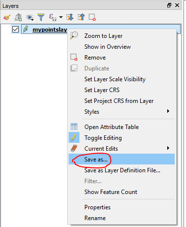
  • Projecting shapefiles in QGIS is easy. Load the shapefile in the project and select its CRS. Then right click on the layer, choose Save as, and save to a new shapefile with the new CRS.
    – Vale
    Commented Apr 23, 2018 at 13:03
  • are your points actually in 102121?
    – Ian Turton
    Commented Apr 23, 2018 at 13:03
  • After starting from scratch, and saving the csv as a points layer in the same projection, it worked and aligns with my block groups. Even though the projection was specified in the "properties" tab as being the same as the polygon layer, the misalignment clearly indicated otherwise. From now on, I will always start by saving as a specified projection, then pulling that layer in (instead of messing with the layers as is and compounding the problem with all my edits). Thank you guys!
    – Ashley
    Commented Apr 23, 2018 at 19:11
  • @IanTurton That's an Esri number, but EPSG doesn't have any foot-based Michigan "GeoRef" definition.
    – mkennedy
    Commented Apr 23, 2018 at 19:23
  • I'm having the same issue all over again, with a different csv I am attempting to reproject to NAD 1983 Michigan GeoRef Feet. Is it because this specific datum for Michigan is not being recognized as officially registered by QGIS?
    – Ashley
    Commented Apr 24, 2018 at 17:24

1 Answer 1

2

A common error with projections in QGIS is confusing the idea of setting a layer's projection and changing a layer's projection.

Setting the projection:

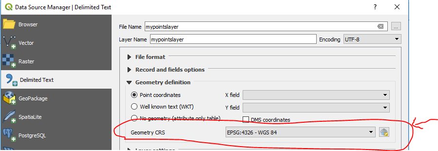
Your csv file was created in a certain projection. When you import the csv, you must set its projection to that same projection. If you choose the wrong projection, QGIS will interpret the csv as though it was in that incorrect projection, and the points will be misaligned.

enter image description here

Changing the projection:

When you convert the csv to a shapefile, you can change the projection at the same time.

Right click on the layer name in the layer panel > Save as... enter image description here

Now choose whatever projection you want. QGIS will create a shapefile of the points from the csv in that projection.

enter image description here

Your Answer

By clicking “Post Your Answer”, you agree to our terms of service and acknowledge you have read our privacy policy.

Not the answer you're looking for? Browse other questions tagged or ask your own question.