I am trying to plot a point using specific co-ordinates in QGIS 3.2.2 and have been told to use 'numerical digitize' or similar to do this. I can't find a plugin that QGIS 3.2.2 will accept. Can anyone help?
3 Answers
You can use the Vertex Tool to edit the coordinates of an existing point. This method is good if you only have a few points to create.
To do this, click the Vertex Tool button in the Digitizing Toolbar:
Right click on the point. Click "vertex editor" in the menu that pops up.
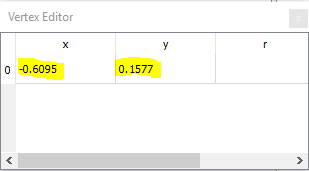
This opens the vertex editor window, where you can manually type in values for X and Y coordinates. Remember if your coordinates are latitude and longitude, longitude is the X coordinate and latitude is the Y coordinate.
As @Erik suggested, you can also put your coordinates in a CSV file. This method is good if you have many points. The process is described in detail here: How to add delimited text layer in QGIS 3.0?
If you want to change the coordinates of a point after your points are loaded into QGIS, use the vertex tool as described above.
-
Thanks, that seems to have worked! Just wish there was a compatible version of numerical digitize' as that's easier (I was shown what to do on an older version then got stumped when I looked at mine).– KathyCommented Sep 20, 2018 at 17:10
-
You could install an older version of QGIS and use it when you need an older feature. I always keep a copy of the long-term release installed.– cskCommented Sep 20, 2018 at 17:19
-
Yes I think I'll have to resort to that. This was set up for me so I didn't know any better. Can you go between the two versions and still open the same file?– KathyCommented Sep 20, 2018 at 20:04
-
You can always put you coordinates into a csv-file and load that into QGis.
You could use the Advanced Digitizing panel!
It requires that your project/data is in a projected coordinate system, but that's it. And it is included in the standard installation of QGIS.
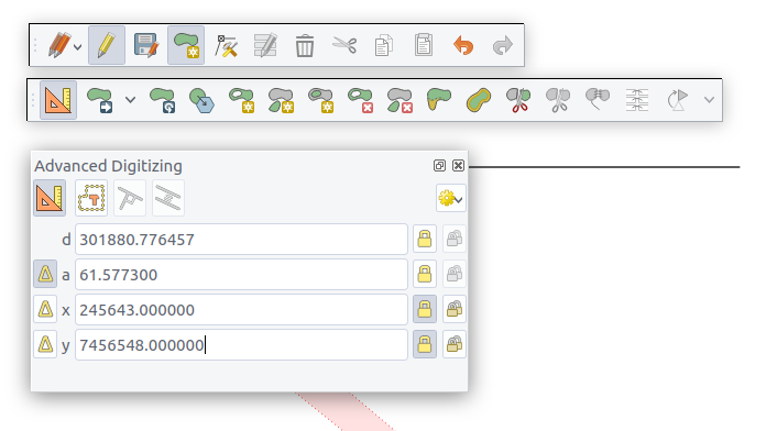
Activate the Advanced digitizing toolbar and click the "enable advanced digitizing tools", or activate the Advanced Digitizing Panel directly.
You need to be in "edit" mode (the pen) and having the Add Feature or Vertex Tool active, in order to be able to fill in coordinates.
Just type in the x and y coordinates and "lock" them (just press enter or click the "lock" button). Then you can click anywhere in the map to add the point at the given coordinate. You can jump to the x and y fields by pressing "x" or "y" on the keyboard.


