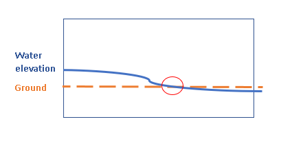
I am trying to find where 2 raster cells values intersect. I have a ground DEM raster and a water elevation raster. I need to find where are values meeting and export the cells. In the graphic below, the red circle is the cell that I want to find and export in ArcGIS 10.5 using raster calculator if possible.
1 Answer
You should be able to use the Conditional tool, either standalone or in Raster Calculator. Set your conditional statement so that wherever Mask=Water will be 1, and everywhere else will be 0. Something like this:
Con(Water=Mask, 1, 0)
This will produce a binary raster marking the waterline. If you need to know the height of the waterline you could then use this waterline raster as a mask against either of the original layers (Extract by Mask).
For further details on using the Conditional tools you can look at this page on conditional evaluation.
-
I've tried that. This only gave me a mask of area that both rasters are overlapped spatially (which it will be the same extent as the input water raster). It doesn't produce a raster that is showing only water and ground elevations are intersecting or meeting, or maybe I am using the wrong expression?– penguinCommented Aug 2, 2019 at 20:35
-
-
penguin - Can you provide the exact expression you are using? And as @FelixIP points out, this solution will only pick up cells where water and the DEM are the exact same elevation. It won't pick up someplace where they meet "between" two neighboring cells. Commented Aug 5, 2019 at 14:50

