4

Given the points:

A) N 38° 38.000 W 90° 20.000
B) N 38° 39.000 W 90° 21.000

(I can calculate the distance between the 2 using a spherical earth model as 7710 feet, though it's not particularly relevant.)

Given those points and 2 other distances, say 4,000 ft and 5,000 ft, how do a find the 2 points that are 4,000 feet from point A and 5,000 feet from point B (thus forming one triangle to the north east and one triangle to the south west.
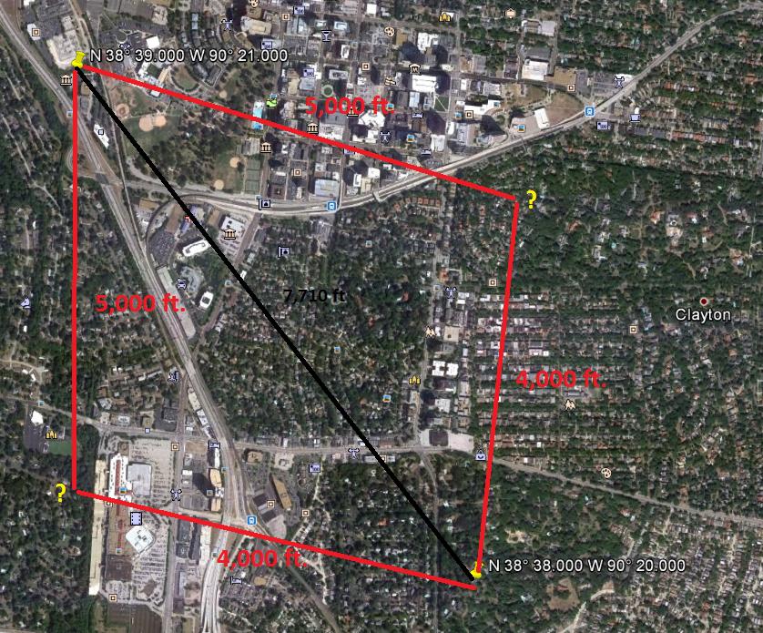
map

Any help converting coordinate systems if I need to is appreciated as well, and extra credit if you can point me towards a .Net library, c# function or Java function.

1 Answer 1

1

The answer, unfortunately, requires spherical trigonometry.

It is like normal trig, just more complex. You will need to know some things like eccentricities (maybe, but perhaps that's only if you have different heights... I gladly have never need to apply what I learnt about this!)

What I would do, though I'm not sure this is the best way, is to find one of the angles between a known point and each of the unknowns (it will be the same both sides, I think), then use that along with the distance to work out coordinates of the destination.

More reading: - http://www.astro.uvic.ca/~tatum/celmechs/celm3.pdf - http://trac.osgeo.org/openlayers/wiki/GreatCircleAlgorithms

5
  • 1
    Not homework... geocaching puzzle. I haven't taken a math class in 16 years!
    – Brad Urani
    Commented Oct 2, 2012 at 1:32
  • Well, I like math, and I hate spherical trig! What about simply scaling on a map? Get in Google Earth and plot your two points, then use a ruler in GE to work out approximate new coordinates. That's much easier than the math (though the math isn't too hard!).
    – Alex Leith
    Commented Oct 2, 2012 at 1:58
  • That won't work... this is part of a puzzle that will involve a recursive algorithm that will have to run this calculation several million times. Afraid I'll need a formula. I appreciate the tips though, that should help me check my work.
    – Brad Urani
    Commented Oct 2, 2012 at 2:48
  • How precisely located is the geocache? Is it buried? If you created a custom UTM projection centered on your area of interest and entered your points, you would get a nearly distortion-free Euclidean coordinate system that's accurate to within a few feet.
    – dmahr
    Commented Oct 2, 2012 at 5:03
  • When I solve the puzzle, I should have the answer to within a foot of the cache location, if I use the same spherical earth model used to create the puzzle. The location could be anywhere in a 20 mile radius though, which means taking a short cut with the geometry could send me bushwhacking in the wrong place forever. Solving this will require several nights of writing brute-force problem solving algorithms, so I feel like should get the basic calculations right if I'm going to go through all that trouble.
    – Brad Urani
    Commented Oct 2, 2012 at 15:41

Your Answer

By clicking “Post Your Answer”, you agree to our terms of service and acknowledge you have read our privacy policy.

Not the answer you're looking for? Browse other questions tagged or ask your own question.