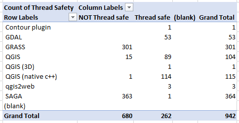
This question is not as straightforward as it seems, but can be summed up with the following:
Is there a definitive list of geoprocessing tools for QGIS that currently support multithreaded processing? The intent is to use more than a single core.
It is well understood that multithreaded rendering is available in QGIS 3, but this has no effect on geoprocessing operations, and in the question history on the various stacks seems to commonly be confused by respondants.
Background: Datasets are becoming more detailed as acquisition methods increase in detail and density. The requirement for detailed analysis combining multiple datasets and myriad steps to process means that multithreaded processing is an attractive option. For example, ESRI has introduced a small but important handful of multithreaded processing tools in ArcGIS Pro - Pairwise Intersect, Pairwise Buffer, and Pairwise Dissolve. These tools have introduced significant speed enhancements to the traditional intersect, buffer, and dissolve functions when handling large datasets.
QGIS interfaces with a number of GIS toolchains - GDAL, GEOS, Python3 / Cython / Shapely / PostGIS - each which has a different position on whether they support multithreaded or parallel processing. It's really very difficult to know whether a tool you wish to use in QGIS supports multithreaded processing, or which tool from which toolchain might offer a speed improvement without a list of tools that support multithreading. This becomes even more important to users of large datasets when building models that might need to be run with semi regularity.
Despite extensive searching I'm coming up with very little.
So, to answer this question are you either able to point to a preexisting list, or your own list of multithreaded processing options for QGIS?

