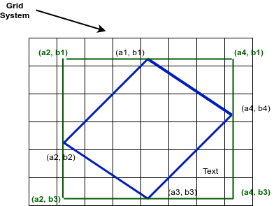
I have several TIFF images which were taken from an aircraft. The images are tilted. Hence, the orientation of the images are not in parallel to the grid system.
Please do refer to the below image: (Image borders are in blue color, while bounding box is in green color) According to the image, what I have are following values:
- coordinate values with respect to the four corners of the image: (a1,b1), (a2,b2), (a3,b3), and (a4,b4).
- from the values I can get the bounding box of the image and that would be (a2, b1), (a2, b3), (a4, b3) and (a4, b1).
I'd like to perform geo-referencing of the images using a tool like GeoTools or JAI. In GeoTools, I noted the ReferenceEnvelop class which offers the constructor that takes lower left, lower right, upper left and upper right values of the image. Thus, I reckon it works only for images which the orientation of the image as same as the orientation of the grid system.
I'd like to know how can I create GeoTIFF images from images that are not in same orientation of the grid lines. Instead, for each image, I have the corner coordinates.
I'm looking for a Java or Python technique. (Java is more favored).

