55

I've spent a little while figuring out the answer to this question. It's not immediately obvious from a Google search, so thought it may useful to post the answer on here. There is also an additional question about non-contiguous polygons.

Instant easy answer: use the command:

centroids <- getSpPPolygonsLabptSlots(polys)

(This was found in the class description of the SpatialPolygonsDataFrame R data class for the overarching spatial package in R, sp)

This seems to do exactly the same thing as

cents <- SpatialPointsDataFrame(coords=cents, data=sids@data, proj4string=CRS("+proj=longlat +ellps=clrk66"))

in the following code, which should be replicable on any R installation (try it!)

#Rcentroids
install.packages("GISTools")
library(GISTools)
sids <- readShapePoly(system.file("shapes/sids.shp", package="maptools")[1], 
                      proj4string=CRS("+proj=longlat +ellps=clrk66"))
class(sids)
plot(sids)
writeSpatialShape(sids, "sids")
cents <- coordinates(sids)
cents <- SpatialPointsDataFrame(coords=cents, data=sids@data, 
                  proj4string=CRS("+proj=longlat +ellps=clrk66"))
points(cents, col = "Blue")
writeSpatialShape(cents, "cents")

centroids <- getSpPPolygonsLabptSlots(sids)
points(centroids, pch = 3, col = "Red")

Where cents (blue) and centroids (red) are identical centroids (this should plot should appear after you've run the code):
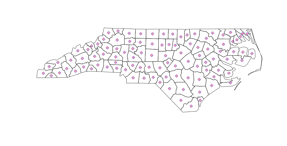
centroids calculated by R

So far so good. But when you calculate polygon centroids in QGIS (menu: Vector | Geometry | Polygon Centroids ), there are slightly different results for non-contiguous polygons:
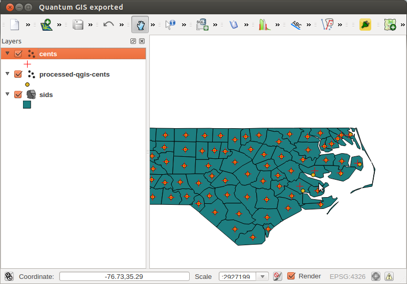
QGIS generated polygons

So this question is 3-things:

  1. A quick and easy answer
  2. A warning for people using R to calculate centroids for non-contiguous polygons
  3. A question about how it should be done in R to properly account for multi-part (non-contiguous) polygons
2
  • I need to know How can I cite the function centroid explained above. Thank's Commented Jul 19, 2018 at 15:37
  • Welcome to GIS StackExchange! As a new user please take the tour. This appears to be a new question, rather than an answer to this question. Please post as a new question.
    – SMiller
    Commented Jul 19, 2018 at 15:43

3 Answers 3

61

Firstly, I can't find any documentation that says that coordinates or getSpPPolygonsLabptSlots returns the centre-of-mass centroid. In fact the latter function now shows up as 'Deprecated' and should issue a warning.

What you want for computing the centroid as the centre-of-mass of a feature is the gCentroid function from the rgeos package. Doing help.search("centroid") will have found this.

trueCentroids = gCentroid(sids,byid=TRUE)
plot(sids)
points(coordinates(sids),pch=1)
points(trueCentroids,pch=2)

should show the difference, and be the same as the Qgis centroids.

3
  • 3
    According to Roger Bivand, developer of a number of R's spatial packages, it does: "Yes. The class documentation at ?"Polygons-class" does not state that this is the case, because other points might be validly inserted as label points. The default constructor uses the centroid of the largest non-hole ring in the Polygons object." - Explains non-contiguity. stat.ethz.ch/pipermail/r-help/2009-February/187436.html . Confirmed: gCentroid(sids,byid=TRUE) does indeed solve the problem. Commented Dec 9, 2012 at 11:16
  • doesn't works for me... even if applying gCentroid(polygon, byid = TRUE) my centroid is places between two polygons.. thus, I assume that those are considered as multipart polygons? how can I split them apart? the points(coordinates(SC.tracks),pch=16, col = "blue", cex = 0.4), however, produce doesn't produce centroid out of polygon... thank you !
    – maycca
    Commented May 12, 2016 at 18:26
  • The link to stat.ethz.ch does not work anymore. Just for completeness sake, I am almost sure the answer now can be found here: r.789695.n4.nabble.com/…
    – Exocom
    Commented Jun 2, 2016 at 6:51
25

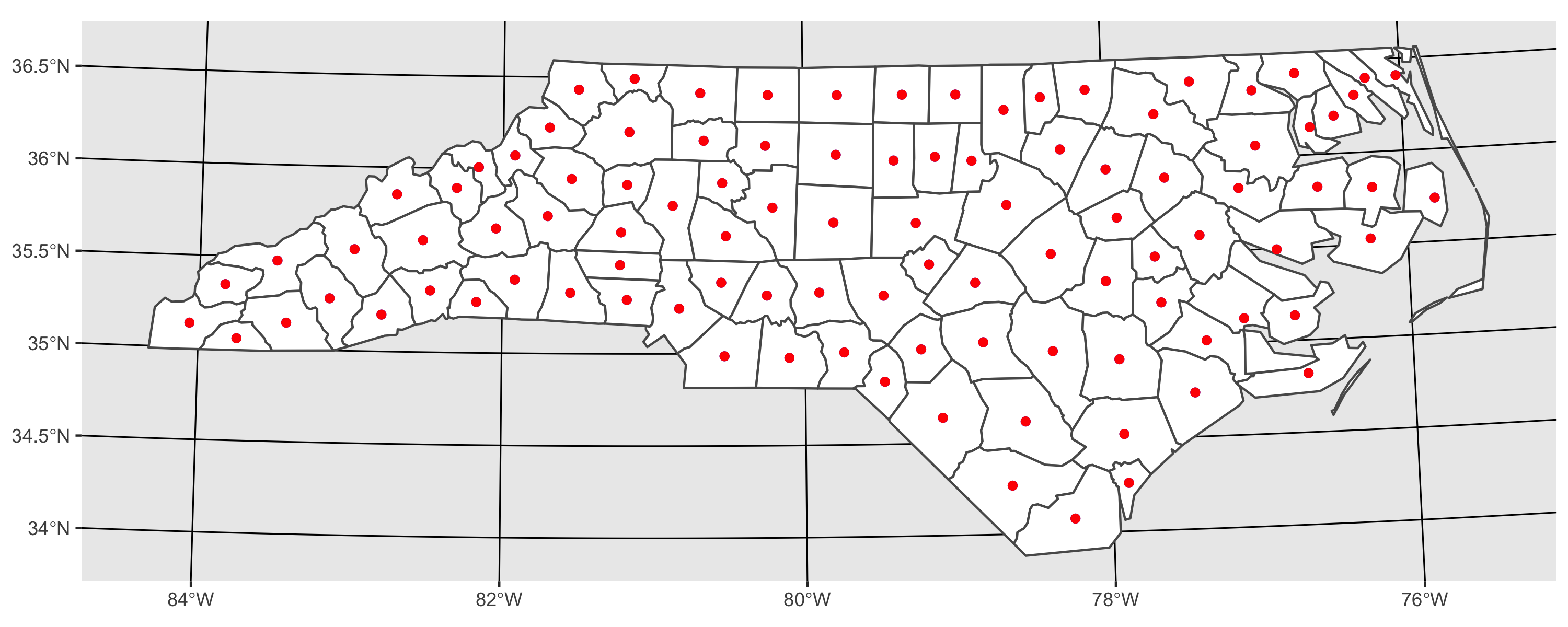
here is an approach using sf. As I demonstrate, results from sf::st_centroid and rgeos::gCentroid are the same.

library(sf)
library(ggplot2)

# I transform to utm because st_centroid is not recommended for use on long/lat 
nc <- st_read(system.file('shape/nc.shp', package = "sf")) %>% 
  st_transform(32617)

# using rgeos
sp_cent <- gCentroid(as(nc, "Spatial"), byid = TRUE)

# using sf
sf_cent <- st_centroid(nc)

# plot both together to confirm that they are equivalent
ggplot() + 
  geom_sf(data = nc, fill = 'white') +
  geom_sf(data = sp_cent %>% st_as_sf, color = 'blue') + 
  geom_sf(data = sf_cent, color = 'red') 

enter image description here

4
  • 1
    Thanks. For completeness, stackoverflow.com/questions/49343958/… shows that they're extremely close, but not quite exactly the same. That said, I don't know which, if any, could be considered "better."
    – hmhensen
    Commented Dec 18, 2019 at 23:02
  • This one worked well for me with sf_cent, just needed to remember to transform back to lat/lon after the transform with %>% st_transform("+proj=longlat +datum=WGS84"), posting this here in case it helps someone else
    – Baroque
    Commented Sep 23, 2021 at 23:30
  • Since version 1 (I think), sf uses the Google S2 geometry library for spherical geometry, and st_centroid() dispatches to S2 for the calculation of the centroid in a spherical polygon. So you can use st_centroid() with long/lat coordinates now.
    – Edward
    Commented Feb 18, 2022 at 13:53
  • great answer! cant wait to try this!
    – stats_noob
    Commented Mar 25, 2023 at 3:35
6

What I did to overcome this problem is to generate a function which negatively buffers the polygon until it is small enough to expect a convex polygon. The function to use iscentroid(polygon)

#' find the center of mass / furthest away from any boundary
#' 
#' Takes as input a spatial polygon
#' @param pol One or more polygons as input
#' @param ultimate optional Boolean, TRUE = find polygon furthest away from centroid. False = ordinary centroid

require(rgeos)
require(sp)

centroid <- function(pol,ultimate=TRUE,iterations=5,initial_width_step=10){
  if (ultimate){
    new_pol <- pol
    # For every polygon do this:
    for (i in 1:length(pol)){
      width <- -initial_width_step
      area <- gArea(pol[i,])
      centr <- pol[i,]
      wasNull <- FALSE
      for (j in 1:iterations){
        if (!wasNull){ # stop when buffer polygon was alread too small
          centr_new <- gBuffer(centr,width=width)
          # if the buffer has a negative size:
          substract_width <- width/20
          while (is.null(centr_new)){ #gradually decrease the buffer size until it has positive area
            width <- width-substract_width
            centr_new <- gBuffer(centr,width=width)
            wasNull <- TRUE
          }
          # if (!(is.null(centr_new))){
          #   plot(centr_new,add=T)
          # }
          new_area <- gArea(centr_new)
          #linear regression:
          slope <- (new_area-area)/width
          #aiming at quarter of the area for the new polygon
          width <- (area/4-area)/slope
          #preparing for next step:
          area <- new_area
          centr<- centr_new
        }
      }
      #take the biggest polygon in case of multiple polygons:
      d <- disaggregate(centr)
      if (length(d)>1){
        biggest_area <- gArea(d[1,])
        which_pol <- 1                             
        for (k in 2:length(d)){
          if (gArea(d[k,]) > biggest_area){
            biggest_area <- gArea(d[k,])
            which_pol <- k
          }
        }
        centr <- d[which_pol,]
      }
      #add to class polygons:
      new_pol@polygons[[i]] <- remove.holes(new_pol@polygons[[i]])
      new_pol@polygons[[i]]@Polygons[[1]]@coords <- centr@polygons[[1]]@Polygons[[1]]@coords
    }
    centroids <- gCentroid(new_pol,byid=TRUE)
  }else{
    centroids <- gCentroid(pol,byid=TRUE)  
  }  
  return(centroids)
}

#Given an object of class Polygons, returns
#a similar object with no holes


remove.holes <- function(Poly){
  # remove holes
  is.hole <- lapply(Poly@Polygons,function(P)P@hole)
  is.hole <- unlist(is.hole)
  polys <- Poly@Polygons[!is.hole]
  Poly <- Polygons(polys,ID=Poly@ID)
  # remove 'islands'
  max_area <- largest_area(Poly)
  is.sub <- lapply(Poly@Polygons,function(P)P@area<max_area)  
  is.sub <- unlist(is.sub)
  polys <- Poly@Polygons[!is.sub]
  Poly <- Polygons(polys,ID=Poly@ID)
  Poly
}
largest_area <- function(Poly){
  total_polygons <- length(Poly@Polygons)
  max_area <- 0
  for (i in 1:total_polygons){
    max_area <- max(max_area,Poly@Polygons[[i]]@area)
  }
  max_area
}
2

Your Answer

By clicking “Post Your Answer”, you agree to our terms of service and acknowledge you have read our privacy policy.

Not the answer you're looking for? Browse other questions tagged or ask your own question.