1

I have a raster file with Unknown Coordinate System and a WKT-file that has the CS information.

How do it connect those two in ArcGIS Pro?

The Define Projection tool gives me an option to create a new coordinate system, but I'm not sure which information in the WKT-file is needed.

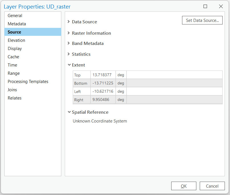
Edit: I have used the Define Projection -tool and created a new coordinate system based on the WKT-file but the raster still opens in wrong location. It seems like the extent coordinates of the raster are wrong, which means it doesn't matter which coordinate system the files is set to as it will still use those wrong extent coordinates to locate the raster. How do I update the raster (not the map) extent coordinates? The extent should be around 125 W and 72 N (Amundsen Gulf).

Here's the WKT-file:

PROJCRS["unknown",
BASEGEOGCRS["unknown",
    DATUM["World Geodetic System 1984",
        ELLIPSOID["WGS 84",6378137,298.257223563,
            LENGTHUNIT["metre",1]],
        ID["EPSG",6326]],
    PRIMEM["Greenwich",0,
        ANGLEUNIT["degree",0.0174532925199433],
        ID["EPSG",8901]]],
CONVERSION["unknown",
    METHOD["Albers Equal Area",
        ID["EPSG",9822]],
    PARAMETER["Latitude of false origin",70.15816,
        ANGLEUNIT["degree",0.0174532925199433],
        ID["EPSG",8821]],
    PARAMETER["Longitude of false origin",-124.81592,
        ANGLEUNIT["degree",0.0174532925199433],
        ID["EPSG",8822]],
    PARAMETER["Latitude of 1st standard parallel",70.09156,
        ANGLEUNIT["degree",0.0174532925199433],
        ID["EPSG",8823]],
    PARAMETER["Latitude of 2nd standard parallel",70.22476,
        ANGLEUNIT["degree",0.0174532925199433],
        ID["EPSG",8824]],
    PARAMETER["Easting at false origin",0,
        LENGTHUNIT["kilometre",1000],
        ID["EPSG",8826]],
    PARAMETER["Northing at false origin",0,
        LENGTHUNIT["kilometre",1000],
        ID["EPSG",8827]]],
CS[Cartesian,2],
    AXIS["(E)",east,
        ORDER[1],
        LENGTHUNIT["kilometre",1000,
            ID["EPSG",9036]]],
    AXIS["(N)",north,
        ORDER[2],
        LENGTHUNIT["kilometre",1000,
            ID["EPSG",9036]]]]

And the extent: enter image description here

Here's the tfw-file from the raster I exported from the NetCDF-file:

0.6857400655 0.0000000000 0.0000000000 -0.6857400655 -10.2788462173 13.3755072589

3
  • Does the raster come with a tfw file, can you show that? The raster extent seems to be placing it approximately over Gulf of Guinea? Something you might try to understand the native units of the raster is to export to ascii then simply open it in notepad and have a look at the xllcorner, yllcorner values, if they are less than 180 then its in decimal degrees, in the thousands its probably metres.
    – Hornbydd
    Commented Nov 28, 2022 at 17:54
  • It's actually a raster saved from NetCDF-file so no tfw. Should I create it? Yes, the original file gets located in the Gulf of Guinea and if I use the Define Projection (WGS84) and Project Raster -tools (by creating a new coordinate system based on the WKT-file) it will get located west of British Columbia on the ocean. I'm worried as the corner values don't look correct whether in degrees or meters, so knowing that seems not helpful.
    – Sn0W
    Commented Nov 28, 2022 at 19:15
  • @Hornbydd I exported the raster into a new raster file and got the tfw-file. I updated the results above.
    – Sn0W
    Commented Nov 29, 2022 at 3:19

1 Answer 1

0

Open up the WKT in notepad and note the name of the coordinate system, for example here is a OGC WKT randomly taken from SpatialReference

PROJCS["Montserrat 1958 / British West Indies Grid", GEOGCS["Montserrat 1958", DATUM["Montserrat_1958", SPHEROID["Clarke 1880 (RGS)",6378249.145,293.465, AUTHORITY["EPSG","7012"]], TOWGS84[174,359,365,0,0,0,0], AUTHORITY["EPSG","6604"]], PRIMEM["Greenwich",0, AUTHORITY["EPSG","8901"]], UNIT["degree",0.01745329251994328, AUTHORITY["EPSG","9122"]], AUTHORITY["EPSG","4604"]], UNIT["metre",1, AUTHORITY["EPSG","9001"]], PROJECTION["Transverse_Mercator"], PARAMETER["latitude_of_origin",0], PARAMETER["central_meridian",-62], PARAMETER["scale_factor",0.9995], PARAMETER["false_easting",400000], PARAMETER["false_northing",0], AUTHORITY["EPSG","2004"], AXIS["Easting",EAST], AXIS["Northing",NORTH]]

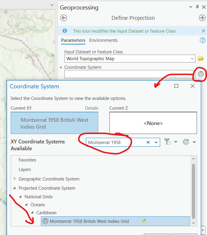
Then in ArcPro when you use the define projection tool you type the name in the search box to drill down to the coordinate system as shown below.

Define Projection Tool

Note - define projection is simply assigning the information to the dataset which came with no information but you know what it is; it is not projecting the coordinate system from one system to another, that's the Project tool.

3
  • Thank you @Hornbydd. This would have been the right answer to the simplest situation but unfortunately mine developed into more complicated one. The name of the coordinate system in the WKT-file was "Unknown" so I just used the parameters to create a new coordinate system but like I mention in the edited question, it seems like the extent of the raster file are not correct so defining and projecting the file still located the raster in a wrong location, hence the updated question.
    – Sn0W
    Commented Nov 28, 2022 at 16:15
  • @Sn0W, ok so what you are not saying in the updated question, is where in the world this is, may be someone else has had similar experience? You processing data deep in Amazonia or a tiny Scottish island? Also include in the question this unknown WKT. Without seeing it no one really has a chance at answering it. What are the current extents of the raster? Is it crossing the date line for example?
    – Hornbydd
    Commented Nov 28, 2022 at 16:22
  • I've added the information to my question, thank you for the suggestions! No crossing date lines, and the location is in Amundsen Gulf.
    – Sn0W
    Commented Nov 28, 2022 at 17:22

Your Answer

By clicking “Post Your Answer”, you agree to our terms of service and acknowledge you have read our privacy policy.

Not the answer you're looking for? Browse other questions tagged or ask your own question.