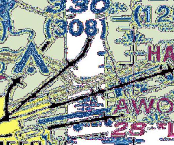
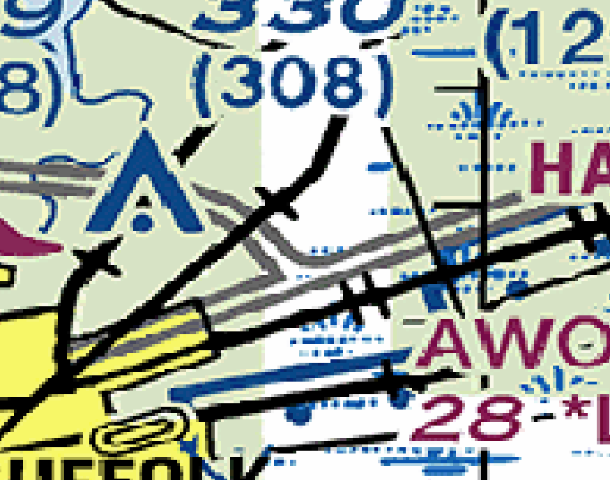
I have a GeoTIFF file and have created a corresponding coverage store and layer inside of GeoServer. Set up went smoothly. However, when I go to view the layer in the Layer Preview, certain colors are distorted. This occurs only in GeoServer. When I open the same file in QGIS or Windows Photo Viewer it displays as expected.
I am just using the "raster" style in GeoServer for this layer. I'm using the Coverage Band Details from the file ("Reload band definitions"), which is a single band titled PALETTE_INDEX. It seems to be handling the color palette incorrectly because some colors appear correct and others are not. See a comparison of how the file appears in GeoServer WMS vs how it appears in QGIS or an image viewer.
Is there additional setup I need to do for GeoServer can render this image properly? Or is this a limitation inside GeoServer?
I am using GeoServer 2.21.0.
Here's the output provided by gdalinfo for this file:
Driver: GTiff/GeoTIFF
Files: Sectional-Basemap.tif
Size is 18470, 10643
Coordinate System is:
GEOGCRS["WGS 84",
    DATUM["World Geodetic System 1984",
        ELLIPSOID["WGS 84",6378137,298.257223563,
            LENGTHUNIT["metre",1]]],
    PRIMEM["Greenwich",0,
        ANGLEUNIT["degree",0.0174532925199433]],
    CS[ellipsoidal,2],
        AXIS["geodetic latitude (Lat)",north,
            ORDER[1],
            ANGLEUNIT["degree",0.0174532925199433]],
        AXIS["geodetic longitude (Lon)",east,
            ORDER[2],
            ANGLEUNIT["degree",0.0174532925199433]],
    ID["EPSG",4326]]
Data axis to CRS axis mapping: 2,1
Origin = (-79.948223406597407,40.279214486163497)
Pixel Size = (0.000449207687334,-0.000449207687334)
Metadata:
  AREA_OR_POINT=Area
  TIFFTAG_DATETIME=2022:10:07 10:28:05
  TIFFTAG_RESOLUTIONUNIT=2 (pixels/inch)
  TIFFTAG_SOFTWARE=Adobe Photoshop CC 2019 (Windows)
  TIFFTAG_XRESOLUTION=300
  TIFFTAG_YRESOLUTION=300
Image Structure Metadata:
  INTERLEAVE=BAND
Corner Coordinates:
Upper Left  ( -79.9482234,  40.2792145) ( 79d56'53.60"W, 40d16'45.17"N)
Lower Left  ( -79.9482234,  35.4982971) ( 79d56'53.60"W, 35d29'53.87"N)
Upper Right ( -71.6513574,  40.2792145) ( 71d39' 4.89"W, 40d16'45.17"N)
Lower Right ( -71.6513574,  35.4982971) ( 71d39' 4.89"W, 35d29'53.87"N)
Center      ( -75.7997904,  37.8887558) ( 75d47'59.25"W, 37d53'19.52"N)
Band 1 Block=18470x1 Type=Byte, ColorInterp=Palette
  Color Table (RGB with 256 entries)
    0: 255,255,255,255
    1: 255,255,0,255
    2: 255,0,255,255
    3: 255,0,0,255
    4: 0,255,255,255
    5: 0,255,0,255
    6: 0,0,255,255
    7: 0,0,0,255
    8: 252,252,254,255
    9: 232,252,254,255
   10: 216,228,198,255
   11: 184,135,136,255
   12: 187,152,154,255
   13: 232,209,211,255
   14: 145,73,88,255
   15: 169,106,120,255
   16: 196,20,63,255
   17: 87,9,29,255
   18: 44,21,29,255
   19: 137,8,55,255
   20: 157,23,71,255
   21: 153,48,86,255
   22: 185,132,153,255
   23: 115,8,53,255
   24: 171,47,105,255
   25: 198,81,134,255
   26: 141,72,104,255
   27: 205,104,153,255
   28: 155,86,119,255
   29: 163,116,139,255
   30: 171,21,96,255
   31: 135,24,80,255
   32: 136,41,88,255
   33: 168,136,152,255
   34: 97,25,63,255
   35: 148,18,90,255
   36: 143,56,104,255
   37: 120,11,73,255
   38: 132,102,123,255
   39: 205,183,200,255
   40: 189,165,184,255
   41: 108,87,104,255
   42: 172,146,168,255
   43: 24,8,24,255
   44: 88,72,88,255
   45: 216,200,216,255
   46: 232,216,232,255
   47: 248,232,248,255
   48: 89,50,104,255
   49: 51,31,93,255
   50: 148,146,152,255
   51: 8,8,24,255
   52: 88,88,105,255
   53: 199,199,217,255
   54: 232,232,248,255
   55: 120,120,123,255
   56: 184,184,186,255
   57: 71,72,92,255
   58: 33,40,120,255
   59: 102,104,128,255
   60: 8,15,85,255
   61: 165,167,185,255
   62: 8,22,107,255
   63: 8,51,183,255
   64: 50,56,76,255
   65: 142,149,171,255
   66: 8,40,120,255
   67: 28,56,120,255
   68: 8,40,104,255
   69: 8,52,136,255
   70: 25,72,153,255
   71: 51,72,107,255
   72: 27,56,99,255
   73: 8,68,152,255
   74: 8,56,120,255
   75: 9,42,85,255
   76: 24,72,136,255
   77: 10,85,175,255
   78: 8,23,41,255
   79: 64,94,127,255
   80: 201,216,232,255
   81: 8,72,135,255
   82: 8,56,104,255
   83: 28,113,202,255
   84: 24,88,152,255
   85: 56,138,220,255
   86: 43,104,168,255
   87: 31,75,119,255
   88: 40,90,140,255
   89: 60,128,200,255
   90: 76,119,159,255
   91: 134,194,247,255
   92: 23,104,172,255
   93: 43,119,183,255
   94: 52,105,150,255
   95: 8,88,152,255
   96: 24,88,136,255
   97: 92,136,170,255
   98: 113,150,178,255
   99: 146,176,200,255
  100: 90,151,194,255
  101: 119,167,202,255
  102: 69,136,178,255
  103: 8,88,136,255
  104: 23,104,151,255
  105: 118,183,219,255
  106: 180,215,233,255
  107: 21,39,47,255
  108: 136,192,217,255
  109: 148,205,232,255
  110: 172,202,216,255
  111: 112,138,149,255
  112: 152,199,216,255
  113: 88,136,152,255
  114: 71,88,93,255
  115: 119,168,178,255
  116: 136,185,195,255
  117: 211,235,240,255
  118: 100,124,127,255
  119: 140,168,171,255
  120: 85,110,112,255
  121: 162,184,186,255
  122: 180,232,235,255
  123: 152,233,234,255
  124: 8,24,24,255
  125: 152,216,216,255
  126: 155,200,200,255
  127: 192,216,216,255
  128: 232,248,248,255
  129: 199,200,200,255
  130: 196,248,246,255
  131: 152,216,200,255
  132: 151,200,183,255
  133: 168,216,200,255
  134: 183,232,215,255
  135: 134,169,151,255
  136: 168,200,184,255
  137: 200,233,216,255
  138: 56,72,63,255
  139: 160,184,168,255
  140: 197,216,200,255
  141: 8,24,8,255
  142: 24,40,24,255
  143: 200,248,200,255
  144: 72,88,72,255
  145: 88,104,88,255
  146: 184,216,184,255
  147: 200,232,200,255
  148: 104,120,104,255
  149: 216,248,216,255
  150: 184,200,184,255
  151: 216,232,216,255
  152: 232,248,232,255
  153: 168,216,164,255
  154: 168,200,166,255
  155: 120,138,114,255
  156: 184,216,168,255
  157: 200,232,184,255
  158: 216,248,200,255
  159: 136,168,119,255
  160: 152,168,139,255
  161: 168,184,152,255
  162: 184,200,168,255
  163: 200,216,184,255
  164: 216,232,200,255
  165: 232,248,216,255
  166: 168,200,127,255
  167: 184,200,151,255
  168: 200,216,168,255
  169: 216,232,184,255
  170: 232,248,200,255
  171: 161,175,114,255
  172: 212,230,144,255
  173: 196,213,123,255
  174: 216,232,105,255
  175: 183,196,104,255
  176: 232,248,104,255
  177: 232,248,120,255
  178: 207,210,104,255
  179: 243,244,145,255
  180: 248,248,71,255
  181: 229,227,68,255
  182: 24,24,8,255
  183: 248,248,88,255
  184: 88,88,34,255
  185: 129,128,51,255
  186: 177,177,73,255
  187: 248,248,104,255
  188: 232,232,99,255
  189: 248,248,120,255
  190: 232,232,133,255
  191: 216,216,166,255
  192: 248,248,200,255
  193: 88,88,71,255
  194: 168,168,136,255
  195: 200,200,168,255
  196: 216,216,184,255
  197: 232,232,199,255
  198: 248,248,216,255
  199: 168,168,152,255
  200: 184,184,168,255
  201: 200,200,184,255
  202: 216,216,200,255
  203: 232,232,216,255
  204: 248,248,232,255
  205: 49,49,48,255
  206: 210,207,84,255
  207: 156,152,58,255
  208: 45,44,21,255
  209: 186,184,152,255
  210: 107,105,88,255
  211: 142,140,119,255
  212: 146,145,136,255
  213: 248,232,102,255
  214: 248,240,176,255
  215: 232,207,88,255
  216: 232,210,104,255
  217: 248,228,120,255
  218: 136,127,85,255
  219: 193,183,133,255
  220: 208,198,149,255
  221: 123,120,104,255
  222: 206,173,79,255
  223: 235,214,159,255
  224: 186,168,133,255
  225: 232,216,184,255
  226: 248,232,200,255
  227: 185,144,67,255
  228: 216,197,168,255
  229: 168,152,136,255
  230: 185,168,152,255
  231: 248,231,216,255
  232: 185,131,91,255
  233: 216,197,184,255
  234: 200,180,168,255
  235: 185,152,136,255
  236: 168,136,135,255
  237: 24,8,8,255
  238: 169,91,91,255
  239: 89,71,71,255
  240: 149,120,120,255
  241: 107,87,87,255
  242: 126,104,104,255
  243: 168,152,152,255
  244: 184,168,168,255
  245: 216,200,200,255
  246: 248,232,232,255
  247: 72,68,68,255
  248: 248,248,248,255
  249: 232,232,232,255
  250: 216,216,216,255
  251: 168,168,168,255
  252: 104,104,104,255
  253: 88,88,88,255
  254: 24,24,24,255
  255: 8,8,8,255
Here is the GeoServer log during a WMS GetMap request:
09 026 15:26:35 INFO [geoserver.flow] - Request [WMS 1.3.0 GetMap] starting, processing through flow controllers
09 026 15:26:35 INFO [geoserver.flow] - Request control-flow performed, running requests: 1, blocked requests: 0
09 026 15:26:35 DEBUG [lite.gridcoverage2d] - Rendering using interpolation javax.media.jai.InterpolationBilinear@5dd7bf8d
09 026 15:26:35 DEBUG [lite.gridcoverage2d] - Rendering using interpolation javax.media.jai.InterpolationBilinear@5dd7bf8d
09 026 15:26:35 DEBUG [lite.gridcoverage2d] - Rendering using interpolation javax.media.jai.InterpolationBilinear@5dd7bf8d
09 026 15:26:35 DEBUG [grid.io] - coverageName:Sectional-Basemap,imageChoice:0,subSamplingFactorX:24,subSamplingFactorY:24
09 026 15:26:35 DEBUG [grid.io] - Coverage read: width = 770 height = 444
09 026 15:26:35 DEBUG [lite.gridcoverage2d] - CoverageDimensionCustomizerReader.GridCoverageWrapper["Sectional-Basemap", GeneralEnvelope[(-79.9482234065974, 35.49829706986711), (-71.65135742153734, 40.2792144861635)], DefaultGeographicCRS["WGS 84"]]
│ PALETTE_INDEX([0.0 ... 255.0])
│ Category("data0":[0.0 ... 255.0])
└ Image=RenderedOp["ImageRead"]
09 026 15:26:35 DEBUG [lite.gridcoverage2d] - Applying Raster Symbolizer
09 026 15:26:35 DEBUG [lite.gridcoverage2d] - GridCoverage2D["Sectional-Basemap", GeneralEnvelope[(-79.9482234065974, 35.49829706986711), (-71.65135742153734, 40.2792144861635)], DefaultGeographicCRS["WGS 84"]]
└ Image=RenderedOp["Scale"]
09 026 15:26:35 INFO [geoserver.wms] -
Request: getMap
Angle = 0.0
BaseUrl = {removed}
Bbox = SRSEnvelope[35.4638671875 : 40.31982421875, -80.013427734375 : -71.575927734375]
BgColor = java.awt.Color[r=255,g=255,b=255]
Buffer = 0
Clip = null
CQLFilter = null
Crs = GEOGCS["WGS 84",
DATUM["World Geodetic System 1984",
SPHEROID["WGS 84", 6378137.0, 298.257223563, AUTHORITY["EPSG","7030"]],
AUTHORITY["EPSG","6326"]],
PRIMEM["Greenwich", 0.0, AUTHORITY["EPSG","8901"]],
UNIT["degree", 0.017453292519943295],
AXIS["Geodetic latitude", NORTH],
AXIS["Geodetic longitude", EAST],
AUTHORITY["EPSG","4326"]]
Elevation = []
Env = {}
Exceptions = application/vnd.ogc.se_inimage
FeatureId = null
FeatureVersion = null
Filter = null
Format = image/jpeg
FormatOptions = {}
Get = true
Height = 442
Interpolations = []
Layers = [org.geoserver.wms.MapLayerInfo@f4badff9]
MaxFeatures = null
Palette = null
RawKvp = {EXCEPTIONS=application/vnd.ogc.se_inimage, REQUEST=GetMap, FORMAT=image/jpeg, CRS=EPSG:4326, BBOX=35.4638671875,-80.013427734375,40.31982421875,-71.575927734375, VERSION=1.3.0, STYLES=, SERVICE=WMS, WIDTH=768, HEIGHT=442, TRANSPARENT=true, LAYERS=Sectional-Basemap}
RemoteOwsType = null
RemoteOwsURL = null
Request = GetMap
RequestCharset = UTF-8
ScaleMethod = null
Sld = null
SldBody = null
SldVersion = null
SortBy = null
SortByArrays = null
SRS = urn:ogc:def:crs:EPSG:4326
StartIndex = null
StyleBody = null
StyleFormat = sld
Styles = [StyleImpl[ name=raster]]
StyleUrl = null
StyleVersion = null
Tiled = false
TilesOrigin = null
Time = []
Transparent = true
ValidateSchema = false
Version = 1.3.0
ViewParams = null
Width = 768
09 026 15:26:36 INFO [geoserver.flow] - releasing flow controllers for [WMS 1.3.0 GetMap]


gdalinfooutput and have a look in the log file to see if it says anything relevant