3

When I create a model in ArcGIS ModelBuilder using the Network Analyst Tools, I am able to create Locations and make the Route Layer and Solve. However, I need to be able to add barriers as well as locations, before solving for the Route.

Is there a way to do this in ArcGIS ModelBuilder?

4
  • The thing that I'm having trouble with now (with the new model that includes barriers) is that when I run the model, then when I click on locations, I don't know if the process sees the locations as barriers or stops. I get error messages when it runs. How can I indicate which I am clicking on when it runs? Thanks. Commented Jan 7, 2013 at 14:11
  • See the screen shot above? The location you're adding is set as a Barrier. The point you provide into each feature set already has its behavior defined. - the easiest way to test this in Desktop is to run it with 2 stops ( each on the same line, with 1 full street inbetween), then add the barrier on the same street inbetween the 2 intersections. The round should move around the barrier instead of straight line
    – KHibma
    Commented Jan 7, 2013 at 16:48
  • OK, thanks. I was able to resolve this and also to integrate the addition of barriers into my C# code. Now I just need to be able to indicate somewhere in the model, that the Barriers input parameter is optional, because I can't use the existing gpk that I created from the model unless I input barriers as well as Stops. Any thoughts? Thanks again! Commented Jan 8, 2013 at 13:49
  • I guess I can't change this input parameter to "optional". I'll have to take another look at my model to see if there is a way around this. Commented Jan 8, 2013 at 14:32

1 Answer 1

2

Barriers (Point, Line and Polygons Barriers) can be created/per-loaded before the solving to route.

Barriers can be added into barrier classes via the Create Network Location ToolCreate Network Location Tool on the Network Analyst toolbar, the Load Locations dialog box, or the Add Locations geoprocessing tool. When barriers are created, loaded, or added, they affect only the items checked on the Network Locations tab of the network analysis layer's Layer Properties dialog box. This is true even when a barrier intersects layers that are unchecked on the Network Locations tab

Loading Point Barriers

When a point barrier is loaded or created, it snaps to the nearest network edge or junction within a search tolerance. The position of the barrier on the network is specified by the network location fields (SourceID, SourceOID, SideOfEdge, and PosAlong). When a restriction point barrier is on an edge, you can opt to restrict travel across the point barrier only, or restrict the edge entirely. A scaled cost point barrier adds a cost whenever it is crossed.

Line and Polygon Barriers also supported

http://resources.arcgis.com/en/help/main/10.1/index.html#//004700000056000000

Edit to add information

This screen shot might help clear it up - just add a new location of "barrier" type to your network analyst layer. In the screen shot, all 3 (start/end/barriers) are feature sets for the user to provide input with.
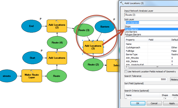
enter image description here

0

Your Answer

By clicking “Post Your Answer”, you agree to our terms of service and acknowledge you have read our privacy policy.

Not the answer you're looking for? Browse other questions tagged or ask your own question.