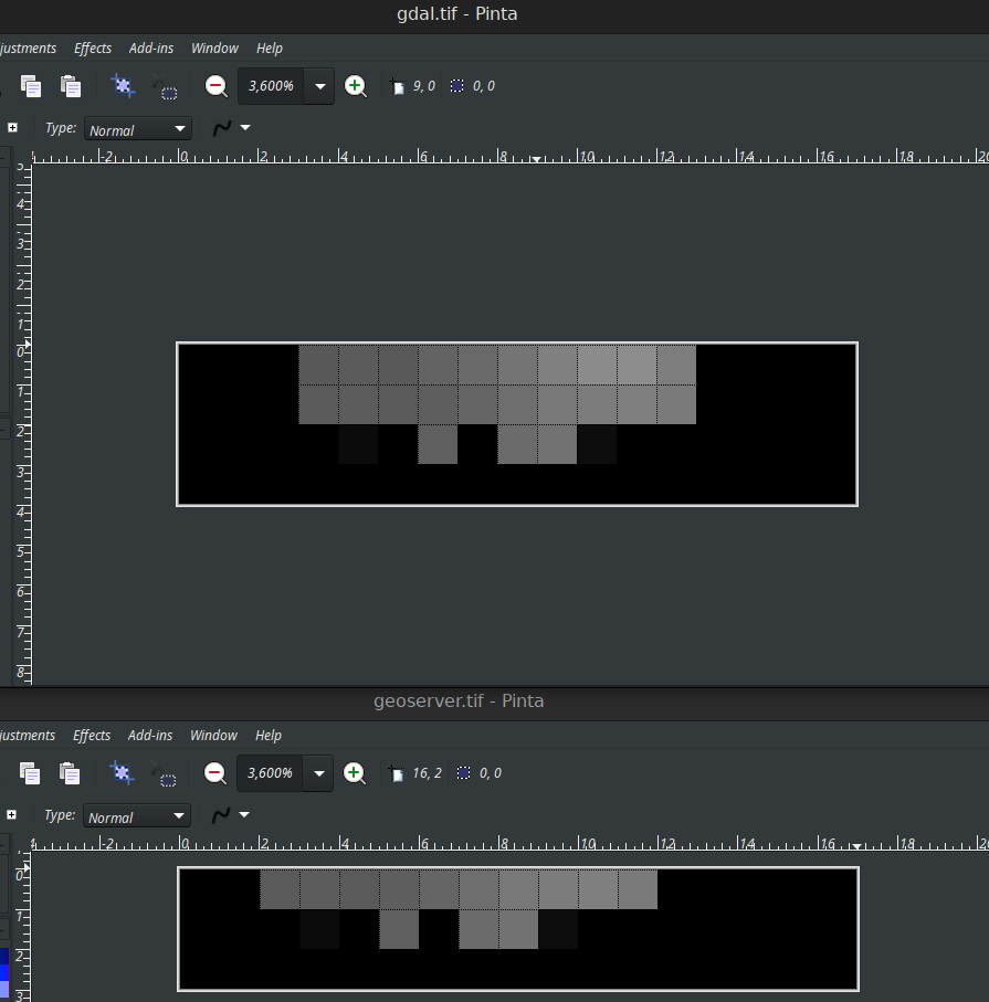
I've a hard time understanding which one should be the correct result by gdal_translate or GeoServer.
My system (Ubuntu 22.04) has:
- GDAL 3.4.1
- Geoserver 2.22 running on Tomcat on port 9090
I have a small tiff file (link to download at the bottom of this thread) in EPSG:4326, then I wanted to have a small subset on Lat and Long axes from it by running:
gdal_translate -projwin 137.915315044103 -36.51629558851893 154.64770004642423 -40.081875882617666 test.tif gdal.tif
curl 'http://localhost:9090/geoserver/wcs?service=WCS&version=2.0.1&request=GetCoverage&format=image/tiff&coverageId=test_raster:output&subset=Lat(-40.081875882617666,-36.51629558851893)&subset=Long(137.915315044103,154.64770004642423)' -o geoserver.tiff
- Then gdalinfo gdal.tif returns:
Size is 17, 4
and gdalinfo geoserver.tif returns
Size is 17, 3
- Also the geo bbox of gdal.tif and geoserver.tif are different. First file gives:
Upper Left ( 136.9750000, -35.9750000)
Second file gives:
Upper Left ( 137.9750000, -36.9750000)
More importantly, the pixels are shifted from gdal.tif at the top to geoserver.tif at the bottom which you can see from this image:
Here is the link to download test.tif, gdal.tif and geoserver.tif https://drive.google.com/file/d/1dawCy38FMwx4J7OQsky-gAHHOXsMuDcy/view?usp=sharing
Which result (gdal.tif or geoserver.tif) should be correct?
Full gdalinfo for gdal.tif
Driver: GTiff/GeoTIFF
Files: gdal.tif
Size is 17, 4
Coordinate System is:
GEOGCRS["WGS 84",
   Data axis to CRS axis mapping: 2,1
Origin = (136.974999999999994,-35.975000000000001)
Pixel Size = (1.000000000000000,-1.000000000000000)
Metadata:
  AREA_OR_POINT=Area
Image Structure Metadata:
  INTERLEAVE=BAND
Corner Coordinates:
Upper Left  ( 136.9750000, -35.9750000) (136d58'30.00"E, 35d58'30.00"S)
Lower Left  ( 136.9750000, -39.9750000) (136d58'30.00"E, 39d58'30.00"S)
Upper Right ( 153.9750000, -35.9750000) (153d58'30.00"E, 35d58'30.00"S)
Lower Right ( 153.9750000, -39.9750000) (153d58'30.00"E, 39d58'30.00"S)
Center      ( 145.4750000, -37.9750000) (145d28'30.00"E, 37d58'30.00"S)
Band 1 Block=17x4 Type=Byte, ColorInterp=Gray
  NoData Value=0
and for geoserver.tif:
Driver: GTiff/GeoTIFF
Files: geoserver.tif
Size is 17, 3
Coordinate System is:
GEOGCRS["WGS 84",
   Data axis to CRS axis mapping: 2,1
Origin = (137.974999999999994,-36.975000000000001)
Pixel Size = (1.000000000000000,-1.000000000000000)
Metadata:
  AREA_OR_POINT=Area
  TIFFTAG_RESOLUTIONUNIT=1 (unitless)
  TIFFTAG_XRESOLUTION=1
  TIFFTAG_YRESOLUTION=1
Image Structure Metadata:
  INTERLEAVE=BAND
Corner Coordinates:
Upper Left  ( 137.9750000, -36.9750000) (137d58'30.00"E, 36d58'30.00"S)
Lower Left  ( 137.9750000, -39.9750000) (137d58'30.00"E, 39d58'30.00"S)
Upper Right ( 154.9750000, -36.9750000) (154d58'30.00"E, 36d58'30.00"S)
Lower Right ( 154.9750000, -39.9750000) (154d58'30.00"E, 39d58'30.00"S)
Center      ( 146.4750000, -38.4750000) (146d28'30.00"E, 38d28'30.00"S)
Band 1 Block=16x16 Type=Byte, ColorInterp=Gray
  NoData Value=0
UPDATE 2: I tested with geotools 29 snapshot with this code below and it returns grid size 18 x 5 instead
        File file = new File("/home/aaa/Downloads/temp/test.tif");

        Hints hint = new Hints();
        hint.put(Hints.DEFAULT_COORDINATE_REFERENCE_SYSTEM, WGS84);
        hint.put(Hints.FORCE_LONGITUDE_FIRST_AXIS_ORDER, Boolean.TRUE);

        GeoTiffReader reader = new GeoTiffReader(file, hint);
        GridCoverage2D coverage = reader.read(null);

        CoverageProcessor processor = CoverageProcessor.getInstance();

        final ParameterValueGroup param = processor.getOperation("CoverageCrop").getParameters();

        // 137.915315044103 -36.51629558851893 154.64770004642423 -40.081875882617666
        double minLong = 137.915315044103;
        double maxLong = 154.64770004642423;
        double minLat = -40.081875882617666;
        double maxLat = -36.51629558851893;

        final GeneralEnvelope crop = new GeneralEnvelope(new GeographicBoundingBoxImpl(minLong, maxLong,
                minLat, maxLat));

        ReferencedEnvelope envelope = new ReferencedEnvelope(new Envelope(minLong, maxLong,
                minLat, maxLat), WGS84);

        param.parameter("Source").setValue(coverage);
        param.parameter("Envelope").setValue(envelope);

        GridCoverage2D cropped = (GridCoverage2D) processor.doOperation(param);

        GridCoverageFactory gcf = new GridCoverageFactory();
        GridCoverage2D gc = gcf.create("name", cropped.getRenderedImage(), cropped.getEnvelope());
        String url = "/tmp/geotools.tif";
        File outputFile = new File(url);
        GeoTiffWriter writer = new GeoTiffWriter(outputFile);
        writer.write(gc, null);
        writer.dispose();
with gdalinfo
gdalinfo /tmp/geotools.tif
Size is 18, 5
Coordinate System is:
GEOGCRS["WGS 84",
Data axis to CRS axis mapping: 2,1
Origin = (136.974999999999994,-35.975000000000001)
Pixel Size = (1.000000000000000,-1.000000000000000)
Metadata:
  AREA_OR_POINT=Area
Corner Coordinates:
Upper Left  ( 136.9750000, -35.9750000) (136d58'30.00"E, 35d58'30.00"S)
Lower Left  ( 136.9750000, -40.9750000) (136d58'30.00"E, 40d58'30.00"S)
Upper Right ( 154.9750000, -35.9750000) (154d58'30.00"E, 35d58'30.00"S)
Lower Right ( 154.9750000, -40.9750000) (154d58'30.00"E, 40d58'30.00"S)
Center      ( 145.9750000, -38.4750000) (145d58'30.00"E, 38d28'30.00"S)
Band 1 Block=18x5 Type=Byte, ColorInterp=Gray
  NoData Value=0


gdalinforesult on both output files