1

I have a shapefile currently in WGS84 within a map projected in British National Grid. The shapefile gets displayed in the right location when in WGS84.

I wanted to redefine its projection to British National Grid so I can send it to other parties and when doing so the layer moves far off despite the fact its CRS is now the correct one.

This probably has an easy explanation but I am a bit baffled.

3
  • 4
    If the location is correct, stay far, far away from Define Projection. Project is used to reproject data; define just corrupts metadata.
    – Vince
    Commented Oct 5, 2023 at 15:21
  • The Define Projection tool changes the projection definition but doesn't actually change the coordinates of the data. It's used for when the projection is incorrect or not defined at all. The Project tool changes the coordinates to a different projection. It's used when the projection is correct but you want to change your data to a different projection.
    – user2856
    Commented Oct 5, 2023 at 21:18
  • 1
    Think of it like 1. changing the file extension of a Word document from .docx to .pdf (Define Projection) versus 2. exporting your Word to to PDF format (Project). The 1. method now results in Word doc that can't be opened but 2. results in a PDF. You would only use 1. if your original file didn't have a file extension at all or had an incorrect file extension (i.e. .txt, .pdf etc) but you knew it was supposed to be a Word doc (.docx)
    – user2856
    Commented Oct 5, 2023 at 21:22

1 Answer 1

2

One explanation may be:

Your source shapefile may be in WGS84, but on the fly, ArcGIS Pro transforms your coordinates into OSGB36, and it looks like you are in the right position (in reality you aren't).

You can clarify easily:

Right-click to layer and choose properties, in the source tab, there is a spatial reference section where you can read the coordinate system that your feature class is using.

If you have WGS84 there, means it is what you are thinking. Then you need to project your data into OSGB36.

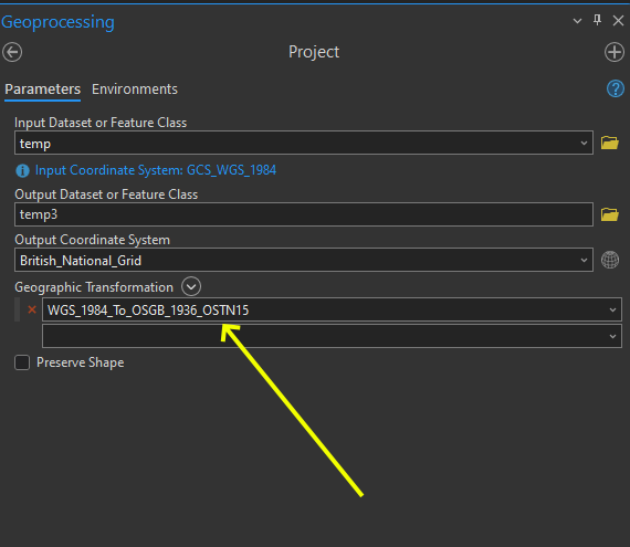
Search for a tool "project", or expand it in Data Management -> Projection and Transformations -> Project. Your tool must look like this screenshot, if for any reason you don't see OSTN15 as a transformation, I suggest you choose it in the drop-down list. enter image description here

1
  • 3
    To access the OSTN15 transformation, you must install the ArcGIS Pro (or Desktop) Coordinate Systems Data package. For more info, see this web page. It's in MyEsri or you might have to add your GIS admin/IT to install it for you.
    – mkennedy
    Commented Oct 5, 2023 at 16:55

Your Answer

By clicking “Post Your Answer”, you agree to our terms of service and acknowledge you have read our privacy policy.

Not the answer you're looking for? Browse other questions tagged or ask your own question.