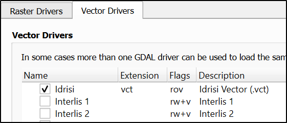
I could re-produce the error with QGIS 3.35, installed with OSGeo4W.
The command log shows that with the default setting QGIS tries to save the polygonozed result into an Interlis 2 file. This format obviously does not support a method that is called "CreateLayer", and the process fails.
Creating output ...
Local/Temp/processing_itbYJS/f14705232a734c5786af2c76250a18d6/OUTPUT.xtf
of format Interlis 2
As a workaround is is possible to de-activate this driver from the settings Options - GDAL - Vector drivers.

After restarting QGIS without Interlis drivers it decided to use GeoPackage as the storage format for the temporary layer.
gdal_polygonize.bat test.tif -b 1 -f "GPKG" ... Temp/processing_pIiZIV/a80ec29dc5ba435bb8d1b22d7796e291/OUTPUT.gpkg OUTPUT DN


Creating output ... Local/Temp/processing_itbYJS/f14705232a734c5786af2c76250a18d6/OUTPUT.xtf of format Interlis 2.It means that QGIS selects a file format that is not suitable for the task. Please write mail to qgis-users list and ask if this bug is already found. The QGIS tools saves the result into a temp file but with Python it should be possible to use gdal.org/drivers/raster/mem.html.