5

I'm a trying to learn QGIS. I am trying to download and open with QGIS 2.0.1 state-specific data from the USGS NHD Viewer, and i think i have at least managed to do the downloading correctly. For example, in efforts to gather data for the state of Florida, i ended up finding, downloading & extracting a compressed folder called NHDH_FL_931v210. extracted from it were 244 items of various file-types (ATX, GDBTABLE, GDBINDEXES, FREELIST, SPX, GDBTABLX) which altogether i assume is an ESRI.gdb and would open in ARC like i am used to. I have QGIS 2.0.1 now and am as green as it gets... i have been trying for a few days to open this data but am not sure really where to begin. When i try to open the files, nothing shows up in the QGIS opener because, i imagine, the files are not recognized by the program.

Do i have the right file downloaded from NHD to display USGS rivers and lakes with QGIS?

Do these files need to be converted? if so, how?

Do i have to connect to the source folder within QGIS like i did in ARC? if so, how?

Do i need to create a GDB in QGIS or is this thing ive downloaded gonna work?

In my research so far i have seen posts from a few years ago (about Wroclaw, an older version of QGIS) that discussed certain steps to take during the installation process in order for ESRI .gdb files to be readable, and if this needs to be done could someone explain this process for 2.0.1 in steps?

Is the new version coming out going to be able to handle this problem i have easier or better?

3
  • 3
    It may also be worthwhile checking out this link: gis.stackexchange.com/questions/26285/…
    – Adam Thom
    Commented Jan 20, 2014 at 17:34
  • 1
    Please phrase the thread title as a question.
    – underdark
    Commented Jan 20, 2014 at 17:39
  • 1
    Like i stated in my question, I have been to that link and the instructions are for an older version of QGIS. Does this still apply to the new version?? Commented Jan 21, 2014 at 12:39

2 Answers 2

3

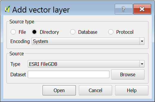
Try the directory radio button within the Add vector layer dialog, see caption below:

enter image description here

2
  • The ESRI FileGDB option may not show up under Type depending on your QGIS installation. I'm not familiar with every method to install QGIS but if, like me, you're on Windows and use OSGEO4W to set up QGIS, the FileGDB driver is not included by default, you need to go into Advanced setup and select it manually.
    – Dan C
    Commented Jan 20, 2014 at 17:53
  • I know i need to change settings in advanced setup, How do i go about doing that?? Please give me a hand! I am on Windows 8 64 bit using osgeo4w, all i need is for the program to read ESRI files Commented Jan 21, 2014 at 12:40
1

I believe NHD .gdb were created in Arc 9. That is the case in WA and OR. Check with a state coordinator to confirm.. You will not be able to use the file geodatabase format in third party software unless you use Arc to upgrade the file to version 10 (see comment from miro) (you could ask a state coordinator to do that or get a trial version). Then you could use QGIS 2.0.1.

Not the answer you're looking for? Browse other questions tagged or ask your own question.