1

This appears to only be a problem when using ArcGIS Desktop 10.0.


I created a shapefile following these criteria as recommended for Performing Geodesic Buffering:

The input feature class must be a point or multipoint dataset. (shapefile is a point) The input feature class must have a geographic coordinate system. (GCS: Longitude/Latitude (WGS 84)) The buffer distance must be specified as a linear unit such as kilometers, miles, or feet. (Radius field (String) added with inputs 3 kilometers, 4.5 kilometers...)

I am not, however, getting accurate geodesic buffers. If I perform a buffer with the same shapefile and input a Linear Unit (3 Kilometers) instead of specifying by the field, I get accurate geodesic buffers.

This was the buffer used with a specified distance which gave me accurate geodesic buffers:

arcpy.Buffer_analysis("test","C:/Temp/testBuffer.shp","3 Kilometers","FULL","ROUND","LIST","Site_Name")

This was the buffer used with a specified field and is NOT giving me accurate geodesic buffers:

arcpy.Buffer_analysis("test","C:/Temp/testBuffer2.shp","Radius","FULL","ROUND","‌​LIST","Site_Name")
11
  • 1
    Would you be able to edit your Question to indicate the exact usage you are submitting (presumably from two runs of the Buffer_analysis tool dialog), please? If you repeat the buffers and use the Geoprocessing | Results window to right-click and Copy As Python Snippet then exactly what you did can be pasted into your Question ready to be formatted as Code.
    – PolyGeo
    Commented Jan 27, 2014 at 21:57
  • This was the buffer usee with a specified distance which gave me accurate geodesic buffers: arcpy.Buffer_analysis("test","C:/Temp/testBuffer.shp","3 Kilometers","FULL","ROUND","LIST","Site_Name")
    – Nicole
    Commented Jan 28, 2014 at 14:20
  • This was the buffer used with a specified field and is NOT giving me accurate geodesic buffers: arcpy.Buffer_analysis("test","C:/Temp/testBuffer2.shp","Radius","FULL","ROUND","LIST","Site_Name")
    – Nicole
    Commented Jan 28, 2014 at 14:26
  • 1
    I just re-created your scenario and came up with the same puzzling answers - not sure what is going on here, but it appears that you cannot trust using the "Field" option - as far as using a WGS84 coordinates system goes anyways.
    – dklassen
    Commented Jan 28, 2014 at 21:45
  • 1
    Could you provide the shapefile for use to try? From our testing it appears to be working correctly in recent releases. But maybe there is something about your data exposing a problem. If ever you run into things not working as expected, please feel free to contact our customer support. We want to know in case there is something we can fix for everyone. 1 (888) 377-4575 Thanks. Ken - ESRI
    – KJHishere
    Commented Aug 3, 2016 at 15:50

1 Answer 1

2
+50

I just tested this in ArcMap 10.3 and it has produced accurate buffers based on the field 'Dist' in my point feature class: arcpy.Buffer_analysis(in_features="//pmgfile01/Users/jb/Documents/ArcGIS/Default.gdb/Point", out_feature_class="//pmgfile01/Users/jb/Documents/ArcGIS/Default.gdb/Point_Buffer", buffer_distance_or_field="Dist", line_side="FULL", line_end_type="ROUND", dissolve_option="NONE", dissolve_field="", method="GEODESIC")


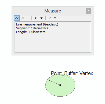
Buffer Created with Dist field: enter image description here


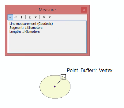
Buffer created setting distance to 1 Kilometer:enter image description here


I tested this in WGS 84. Note that my distances in 'Dist' field look like this: "1 Kilometer". Make sure the units are capitalized in the field. Try loading your data into a geodatabase before running the buffers and see if that improves the result. My point features were stored in a geodatabase and I output the buffers into the same geodatabase. If none of that works, it is likely a bug with 10.0

Your Answer

By clicking “Post Your Answer”, you agree to our terms of service and acknowledge you have read our privacy policy.

Not the answer you're looking for? Browse other questions tagged or ask your own question.