4

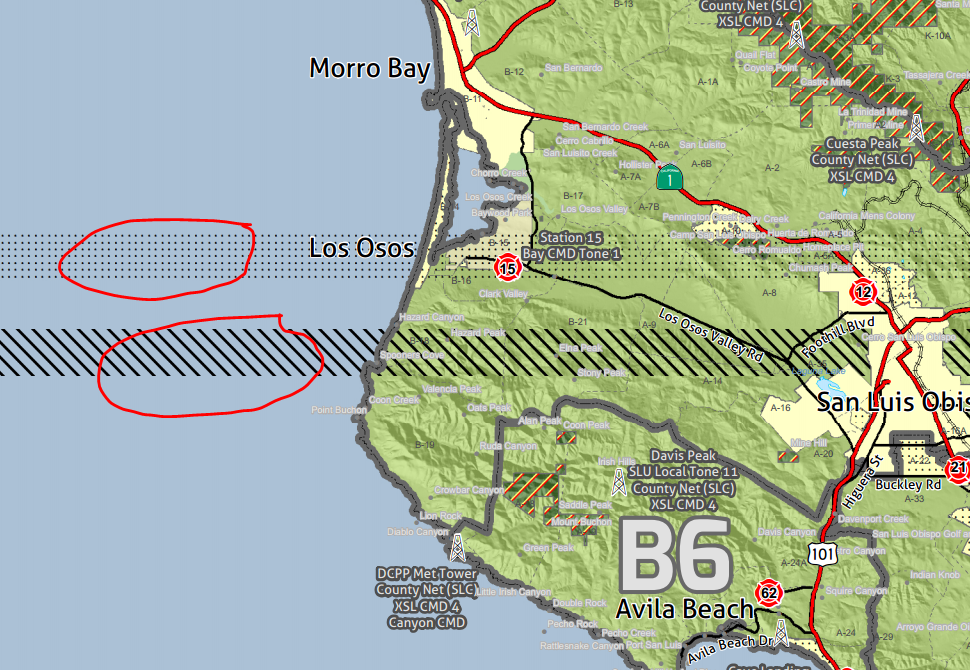
I am attempting to export a large E size map at 300 DPI in ArcMap 10.2.2 but each time I export there are errors on the map. Once the PDF is generated there are areas where symbols are stretched out in a line across the width of the map. I have tried it on ArcMap 10.1 and 10.2.2 and I get the same errors. I know I can avoid these errors if I export at a lower DPI, but I want a really high resolution print of this particular map to be prominently displayed. All other parameters for the export to PDF are the default values.

Here is an example of the errors: example of the errors.
4 Answers 4

2

Last time I saw that (the symbology leak) I had to fix a self intersection in a polygon.
That could be the reason for the error.
But higher resolution pdf creation does take some extra configuration.
Make sure you have plenty of virtual ram set.
Make sure there is plenty of disk space on your temp drive. Ussually c drive.

I think I remember something in the arcgis advance settings.
Look in C:\Program Files (x86)\ArcGIS\Desktop10.2\Utilities\AdvancedArcMapSettings.exe

6
  • I've increased my virtual ram to 20,000 MB from 4,960 MB but I still get the same errors at 300 dpi. I'm not sure how to access the arcgis advanced settings.
    – cbunn
    Commented Jul 11, 2014 at 20:24
  • @cbunn The advanced settings is a standalone exe utility that must be run with all other Arc programs closed. You can find it at C:\Program Files (x86)\ArcGIS\Desktop10.2\Utilities on a default install. Be careful when changing things, as this is essentially editing registry keys.
    – Chris W
    Commented Jul 11, 2014 at 21:36
  • If I change a value in the Advanced settings I can always change it back right? Do you believe increasing the polygon vertex limits for PDF will eliminate this error?
    – cbunn
    Commented Jul 11, 2014 at 21:49
  • yes you can change it back. run it with arcmap closed as admin.
    – Brad Nesom
    Commented Jul 11, 2014 at 22:25
  • have you run repair geometry on (it looks like two different polygons possibly two different layers) the data that is leaking out?
    – Brad Nesom
    Commented Jul 11, 2014 at 22:31
0

Try making the offset 0.0001. It won't show a difference, but it forces arcmap to redraw the symbology of the feature.

0

Consider using this Python snippet in the ArcMap Python Window to narrow things down:

mapDoc = arcpy.mapping.MapDocument("current")
... layerList = arcpy.mapping.ListLayers(mapDoc)
... for layer in layerList:
...     if layer.isRasterizingLayer:
...         print layer.name + " is RASTERIZING"
...         
cnty24k13_1_poly is RASTERIZING
Pacific Ocean Bathymetry is RASTERIZING
cal_ocean_alb is RASTERIZING
Battalions is RASTERIZING
USA Water Body Types is RASTERIZING
SRA14_1 is RASTERIZING
-1

I suggest De-fragmenting ArcGIS Documnet. That will reduce the size of your document by half and will be easy to draw. http://edndoc.esri.com/arcobjects/9.1/ArcGISDevHelp/DeveloperTools/MXDDefrag.htm

Your Answer

By clicking “Post Your Answer”, you agree to our terms of service and acknowledge you have read our privacy policy.

Not the answer you're looking for? Browse other questions tagged or ask your own question.