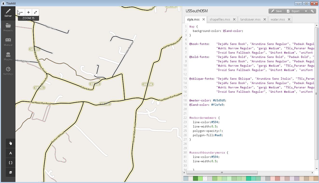
There is an unknown black line in the center of about 80% streets. I have been adjusting line-widths and switching off and on every line layer for hours to no avail.
I am using the latest version of TileMill with the latest openstreetmap-carto style and postgresql. I posted an image below for an example of the black lines that are in the center of the roads. The export looks terrible with these black lines present. I searched for a "road-centerline" style but there were none present that I could find.
I narrowed it down to the layer it is on, #roads-text-name. I'm having an issue though trying to figure out which styling is causing the black lines.
    roads-text-name {
  [highway = 'motorway'],
  [highway = 'trunk'],
  [highway = 'primary'] {
    [zoom >= 13] {
      text-name: "[name]";
      text-size: 8;
      text-fill: black;
      text-spacing: 300;
      text-clip: false;
      text-placement: line;
      text-face-name: @book-fonts;
      [tunnel = 'no'] {
        text-halo-radius: 1;
        [highway = 'motorway'] { text-halo-fill: @motorway-fill; }
        [highway = 'trunk'] { text-halo-fill: @trunk-fill; }
        [highway = 'primary'] { text-halo-fill: @primary-fill; }
      }
    }
    [zoom >= 14] {
      text-size: 9;
    }
    [zoom >= 15] {
      text-size: 10;
    }
    [zoom >= 17] {
      text-size: 11;
    }
  }
  [highway = 'secondary'] {
    [zoom >= 13] {
      text-name: "[name]";
      text-size: 8;
      text-fill: black;
      text-spacing: 300;
      text-clip: false;
      text-placement: line;
      text-face-name: @book-fonts;
      text-halo-radius: 1;
      text-halo-fill: @secondary-fill;
    }
    [zoom >= 14] {
      text-size: 9;
    }
    [zoom >= 15] {
      text-size: 10;
    }
    [zoom >= 17] {
      text-size: 11;
    }
  }
  [highway = 'tertiary'],
  [highway = 'tertiary_link'] {
    [zoom >= 14] {
      text-name: "[name]";
      text-size: 9;
      text-fill: black;
      text-spacing: 300;
      text-clip: false;
      text-placement: line;
      text-face-name: @book-fonts;
      text-halo-radius: 1;
      text-halo-fill: @tertiary-fill;
    }
    [zoom >= 17] {
      text-size: 11;
    }
  }
  [highway = 'proposed'] {
    [zoom >= 15] {
      text-name: "[name]";
      text-size: 9;
      text-fill: black;
      text-spacing: 300;
      text-clip: false;
      text-placement: line;
      text-halo-radius: 1;
      text-halo-fill: rgba(255,255,255,0.6);
      text-face-name: @book-fonts;
      text-opacity: 0.3;
    }
    [zoom >= 17] {
      text-size: 11;
    }
  }
  [highway = 'construction'] {
    [int_construction_minor = 'no'][zoom >= 13],
    [int_construction_minor = 'yes'][zoom >= 14] {
      text-name: "[name]";
      text-size: 9;
      text-fill: black;
      text-spacing: 300;
      text-clip: false;
      text-placement: line;
      text-halo-radius: 1;
      text-halo-fill: rgba(255,255,255,0.6);
      text-face-name: @book-fonts;
      [zoom >= 17] {
        text-size: 11;
      }
    }
  }
  [highway = 'residential'],
  [highway = 'unclassified'],
  [highway = 'road'] {
    [zoom >= 15] {
      text-name: "[name]";
      text-size: 8;
      text-fill: black;
      text-spacing: 300;
      text-clip: false;
      text-placement: line;
      text-halo-radius: 1;
      text-halo-fill: @residential-fill;
      text-face-name: @book-fonts;
    }
    [zoom >= 16] {
      text-size: 9;
    }
    [zoom >= 17] {
      text-size: 11;
      text-spacing: 400;
    }
  }

  [highway = 'raceway'],
  [highway = 'service'] {
    [zoom >= 16] {
      text-name: "[name]";
      text-size: 9;
      text-fill: black;
      text-spacing: 300;
      text-clip: false;
      text-placement: line;
      text-halo-radius: 1;
      [highway = 'raceway'] { text-halo-fill: @raceway-fill; }
      [highway = 'service'] { text-halo-fill: @service-fill; }
      text-face-name: @book-fonts;
    }
    [zoom >= 17] {
      text-size: 11;
    }
  }

  [highway = 'living_street'],
  [highway = 'pedestrian'] {
    [zoom >= 15] {
      text-name: "[name]";
      text-size: 8;
      text-fill: black;
      text-spacing: 300;
      text-clip: false;
      text-placement: line;
      text-halo-radius: 1;
      [highway = 'living_street'] { text-halo-fill: @living-street-fill; }
      [highway = 'pedestrian'] { text-halo-fill: @pedestrian-fill; }
      text-face-name: @book-fonts;
    }
    [zoom >= 16] {
      text-size: 9;
    }
    [zoom >= 17] {
      text-size: 11;
    }
  }
}

