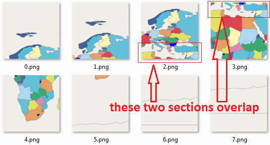
I'm trying to generate map tiles using the mapnik's generate_tiles.py script, but the resulting tiles are overlapped.
Example
The tiles have the following directory structure: zoom_level/x_coordinate/y_coordinate.png.
Tiles 3/4/1.png , 3/4/2.png and 3/4/3.png have some countries shown twice (for example: Turkey and a part of Italy) like in the following image:

Begin Edit
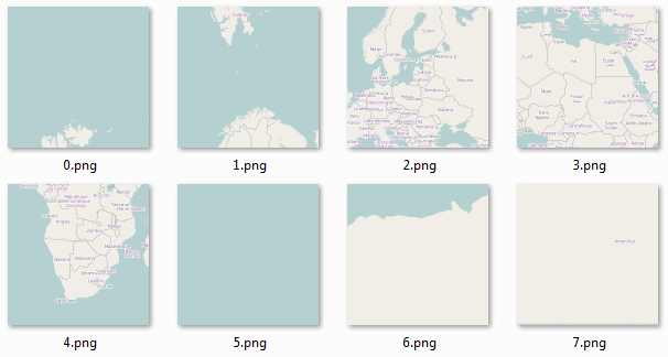
Here is how the tiles should look at the same zoom level as the previous image (zoom level: 3; these tiles were generated using MOBAC with the "OpenStreetMap Mapnik" Map source):

As you can see, in this case there aren't any tiles with overlapping content (or duplicate, if you prefer). Another strange thing is that only the tiles from the middle of the map (3.png and 4.png) look similar (cover approximately the same area). The other tiles (0.png , 1.png and 2.png) look totally different and I don't understand why!!!
Note: this is the first time I generate my own tiles so it's very likely that I'm doing a stupid mistake. It might be related to the projection I use (see below for the osm.xml).
End Edit
I tried setting the self.m.buffer_size to 0 (zero) (like this page says; anyway, that's regarding labels, which I don't need) in:
def render_tile(self, tile_uri, x, y, z):
    # ...

    render_size = 256
    self.m.resize(render_size, render_size)
    self.m.zoom_to_box(bbox)
    self.m.buffer_size = 128

    # Render image with default Agg renderer
    im = mapnik.Image(render_size, render_size)
    mapnik.render(self.m, im)
    im.save(tile_uri, 'png256')
Could it be a problem with the projection? Here are the important bits from my osm.xml file:
<Map bgcolor="#f2efe9" srs="+proj=latlong +datum=WGS84">
and
<Layer name="countries" status="on" srs="+proj=latlong +datum=WGS84">
Can someone help me? I already spent almost a week searching and documenting myself about this process and I got stuck here.
