1

I have a created 500 m buffers around a series of sampling points and want to know how much of a certain habitat is contained within each buffer. I used intersect and summary statistics to calculate length and area of habitat a within one example buffer x and got a value y.

When using the entire set of buffers, the result y for habitat a in buffer x is larger than before. Buffer x overlaps with several other buffers. I am interested in the total amount of habitat within each buffer, regardless of the overlap with another buffer. Hence the result should not be different.

It seems that when several buffers overlap the intersect result consists of multiple sections so that the total length calculated using summary statistics is different.

How can I avoid this problem and get a correct output ?

4
  • In the summary statistics, are you using the buffer's FID as a case field? Commented Sep 5, 2017 at 18:11
  • Yes, I am using the buffer's FID.
    – Julia
    Commented Sep 5, 2017 at 18:25
  • After dissolving the output from intersect and then calculating summary statistics I get matching results for the example buffer x. Would you be able to comment on why this is so ?
    – Julia
    Commented Sep 5, 2017 at 20:24
  • Could you post some screenshots? Commented Sep 5, 2017 at 20:25

1 Answer 1

1

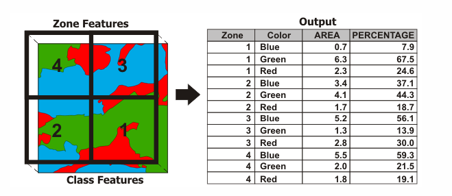
Tabulate Intersection may be what you are looking for. It gives you both an area calculation (which appears to be what you are looking for) as well as a percentage per polygon.

enter image description here

A zone is comprised of all features in the Input Zone Features that have the same values in the Zone Field(s). Similarly, a class is comprised of all features in the Input Class Features that have the same values in the Class Field(s). Features do not have to be contiguous to be in the same zone or class. This tool calculates how much of the zone is intersected by each class (area and percentage of zone area).

If no Class Field(s) is specified, all features in the Input Class Features will be considered a single class. The Output Table will contain one record for each zone.

If Class Field(s) is specified, the Output Table will contain n records for each zone, where n is the number of classes within that zone. For example, if a zone contains four classes, the Output Table will have four records for that zone.

Numeric attributes from the Input Class Features can be summed by zone using the Sum Fields parameter. The sum values for a class represent a proportion of the sum values based on the percentage of the class intersecting the zone (similar to how a Ratio Policy works).

Your Answer

By clicking “Post Your Answer”, you agree to our terms of service and acknowledge you have read our privacy policy.

Not the answer you're looking for? Browse other questions tagged or ask your own question.