4

When I try to export my QGIS file to Adobe Illustrator I either get:

  • The map layout, but I can't change/select the different polygons

  • I can change/select the different polygons, but I don't get the background/colors/layout. Everything is basically black.

  • I tried the SimpleSvg plugin, but QGIS crashes for me when I run it.

The quality of QGIS exports isn't always up to par for me, so I want to alter it in Illustrator.

What are your suggestion(s) for a workflow for QGIS -> Illustrator?

4
  • have you tried exporting to PDF and then open the PDF with Illustrator?
    – Vale
    Commented Oct 30, 2017 at 15:26
  • There might also be helpful info in the answers to this question: gis.stackexchange.com/questions/7078/…
    – csk
    Commented Oct 30, 2017 at 16:28
  • Remember QGIS can only handle RGB so if you're making maps for printing you need to convert the colors to CMYK and see that no strange color combinations occur.
    – oskarlin
    Commented Oct 30, 2017 at 16:38
  • related: gis.stackexchange.com/questions/241162/…
    – Mapperz
    Commented Oct 30, 2017 at 16:55

3 Answers 3

4

I would use this approach:

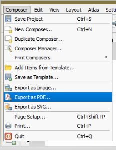
Since, Illustrator has it's setup as standard pages, you should first create a print composer and save the page as either an SVG or a PDF.

enter image description here

As, an alternative for layers, you may want to try exporting into DXF.

1

We send maps to our graphics department to support the District Map poster/pamphlet.

Page 2 of this PDF: https://www.dpsk12.org/wp-content/uploads/2017-18-Map-FINAL_forweb.pdf

I have found that exporting first to SVG, then using Inkscape to remove some of the artifacts that you don't want in your Illustrator project (clipping masks, etc.). You could probably use Illustrator to do this too, but our team doesn't have/want a license.

Then save the 'cleaned' SVG to a PDF, and use in Illustrator.

Another benefit of using the SVG is the text remains 'text' (vs. paths) so can be updated in Illustrator.

If you were using a gradient fill in QGIS, that won't be exported, but that kind of thing is easy to do in Illustrator too.

1

Export PDF works well on map objects while export SVG works well for labels in QGIS 2.18. Illustrator has a Select>Object>Text elements command. Deleting the PDF labels and dropping in the labels from the SVG works fine.

For the line weight issue with SVG exports see this thread: SVG from QGIS to Illustrator CC gets wrong stroke widths

Your Answer

By clicking “Post Your Answer”, you agree to our terms of service and acknowledge you have read our privacy policy.

Not the answer you're looking for? Browse other questions tagged or ask your own question.