0

To generate mosaic of the images I used gdal_merge as shown below.

python gdal_merge.py -o out.tif -n 0 -a_nodata 0 in1.tif in2.tif

I find a clear demarcation between input 1 and input 2 image as shown in the image, but I am expecting the final output with no demarcation or smooth surface in the output. How to rectify it?

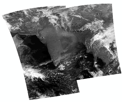
Mosaic from two satellite images

3
  • Have you seen this: gis.stackexchange.com/questions/127310/… Commented Jul 16, 2018 at 10:14
  • I think that there is not much that you can do because it comes from the calibration of the input images (and myabe also a difference of dates, therefore you see different seasons. .
    – radouxju
    Commented Jul 16, 2018 at 11:33
  • Thank you for the replsy.Both the input images are acquired on the same day. Mosaic was done properly by removing the nodata values followed by clipping to the extent and mosaic.
    – Krishna
    Commented Jul 23, 2018 at 11:48

1 Answer 1

1

A bit late to respond to this, but from my experience I had lines between merged images if I converted CRS of each image THEN merged. If I keep the CRS as is (usually UTM), merge then convert CRS that produced a seamless blend.

Also another point to add, usually images will have atmospheric correction (for Sentinel 2 for example: https://sentinel.esa.int/web/sentinel/user-guides/sentinel-2-msi/product-types/level-2a) in some cases,even after applying atmospheric correction, the images still wouldn't be 100% corrected, hence causing the issue above.

Your Answer

By clicking “Post Your Answer”, you agree to our terms of service and acknowledge you have read our privacy policy.

Not the answer you're looking for? Browse other questions tagged or ask your own question.