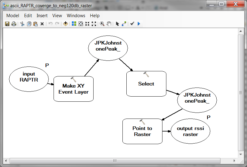
I've made a simple model that takes a CSV of lat/longs with radio signal levels, makes an XY event layer, selects values over -120, then converts to raster. In the Make XY Event layer the spatial reference is set for GCS_NAD83 with datum D_NAD83, which corresponds to the source of the CSV files.
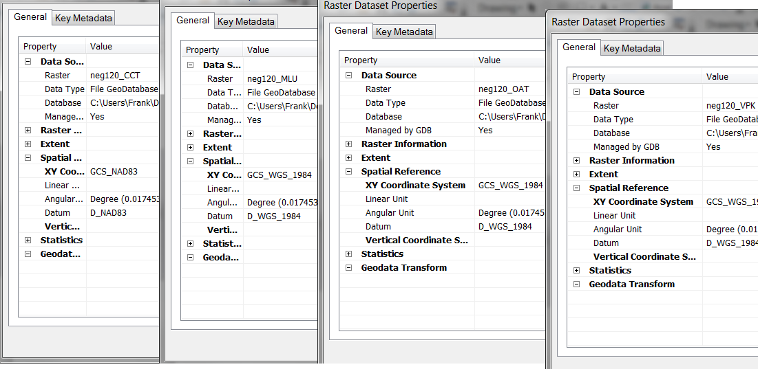
When I run the model by itself it works correctly and returns a raster in NAD83, how ever in batch mode the first raster is returned correcly with NAD83, but all subsequent rasters are return with GCS_WGS_1984 and datum D_WGS_1984.
I've checked the results posted below and they show that each layer is returned as NAD83 in the Make XY Event Layer but when I check the properties they are different. I even get a warning at the end of batch processing that they use Datum.
For your reference I've included the results for four files. In the Make XY Event Layer it shows they are all the same. I've also include screen shots of the properties so you can see that the results differ.
Messages
Executing: RAPTRascii2raster "C:\Users\Frank\Documents\ArcGIS\LAcounty Data\CWIRS\Basin Simulcast\CCTFinalCCTFinal.txt" C:\Users\Frank\Documents\ArcGIS\Default.gdb\neg120_CCT
Start Time: Fri Mar 15 09:48:59 2019
Executing (Make XY Event Layer): MakeXYEventLayer "C:\Users\Frank\Documents\ArcGIS\LAcounty Data\CWIRS\Basin Simulcast\CCTFinalCCTFinal.txt" longitude latitude CCTFinalCCTFinal_Layer "GEOGCS['GCS_NAD83',DATUM['D_NAD83',SPHEROID['GRS_1980',6378137.0,298.257222101]],PRIMEM['Greenwich',0.0],UNIT['Degree',0.0174532925199433]];-400 -400 11258999068426.2;-100000 10000;-100000 10000;8.98315284119521E-09;0.001;0.001;IsHighPrecision" level
Start Time: Fri Mar 15 09:49:00 2019
Executing (Make XY Event Layer): MakeXYEventLayer "C:\Users\Frank\Documents\ArcGIS\LAcounty Data\CWIRS\Basin Simulcast\MLUMountLukens.txt" longitude latitude MLUMountLukens_Layer "GEOGCS['GCS_NAD83',DATUM['D_NAD83',SPHEROID['GRS_1980',6378137.0,298.257222101]],PRIMEM['Greenwich',0.0],UNIT['Degree',0.0174532925199433]];-400 -400 11258999068426.2;-100000 10000;-100000 10000;8.98315284119521E-09;0.001;0.001;IsHighPrecision" level
Executing (Make XY Event Layer): MakeXYEventLayer "C:\Users\Frank\Documents\ArcGIS\LAcounty Data\CWIRS\Basin Simulcast\OATOatMountain.txt" longitude latitude OATOatMountain_Layer "GEOGCS['GCS_NAD83',DATUM['D_NAD83',SPHEROID['GRS_1980',6378137.0,298.257222101]],PRIMEM['Greenwich',0.0],UNIT['Degree',0.0174532925199433]];-400 -400 11258999068426.2;-100000 10000;-100000 10000;8.98315284119521E-09;0.001;0.001;IsHighPrecision" level
Executing (Make XY Event Layer): MakeXYEventLayer "C:\Users\Frank\Documents\ArcGIS\LAcounty Data\CWIRS\Basin Simulcast\VPK-150VerdugoPeak-150.txt" longitude latitude VPK-150VerdugoPeak-150_Layer "GEOGCS['GCS_NAD83',DATUM['D_NAD83',SPHEROID['GRS_1980',6378137.0,298.257222101]],PRIMEM['Greenwich',0.0],UNIT['Degree',0.0174532925199433]];-400 -400 11258999068426.2;-100000 10000;-100000 10000;8.98315284119521E-09;0.001;0.001;IsHighPrecision" level
Succeeded at Fri Mar 15 09:49:55 2019 (Elapsed Time: 54.55 seconds)
Executing (Select): Select CCTFinalCCTFinal_Layer C:\Users\Frank\Documents\ArcGIS\Default.gdb\JPKJohnstonePeak_Select ""level" >= (-120)"
Start Time: Fri Mar 15 09:49:55 2019
Executing (Select): Select MLUMountLukens_Layer C:\Users\Frank\Documents\ArcGIS\Default.gdb\JPKJohnstonePeak_Select ""level" >= (-120)"
Executing (Select): Select OATOatMountain_Layer C:\Users\Frank\Documents\ArcGIS\Default.gdb\JPKJohnstonePeak_Select ""level" >= (-120)"
Executing (Select): Select VPK-150VerdugoPeak-150_Layer C:\Users\Frank\Documents\ArcGIS\Default.gdb\JPKJohnstonePeak_Select ""level" >= (-120)"
Succeeded at Fri Mar 15 10:03:17 2019 (Elapsed Time: 13 minutes 22 seconds)
Executing (Point to Raster): PointToRaster C:\Users\Frank\Documents\ArcGIS\Default.gdb\JPKJohnstonePeak_Select level C:\Users\Frank\Documents\ArcGIS\Default.gdb\neg120_CCT MOST_FREQUENT NONE 0.00083333
Start Time: Fri Mar 15 10:03:17 2019
Executing (Point to Raster): PointToRaster C:\Users\Frank\Documents\ArcGIS\Default.gdb\JPKJohnstonePeak_Select level C:\Users\Frank\Documents\ArcGIS\Default.gdb\neg120_MLU MOST_FREQUENT NONE 0.00083333
Executing (Point to Raster): PointToRaster C:\Users\Frank\Documents\ArcGIS\Default.gdb\JPKJohnstonePeak_Select level C:\Users\Frank\Documents\ArcGIS\Default.gdb\neg120_OAT MOST_FREQUENT NONE 0.00083333
Executing (Point to Raster): PointToRaster C:\Users\Frank\Documents\ArcGIS\Default.gdb\JPKJohnstonePeak_Select level C:\Users\Frank\Documents\ArcGIS\Default.gdb\neg120_VPK MOST_FREQUENT NONE 0.00083333
Succeeded at Fri Mar 15 10:05:03 2019 (Elapsed Time: 1 minutes 45 seconds)
Succeeded at Fri Mar 15 10:05:04 2019 (Elapsed Time: 16 minutes 5 seconds)


