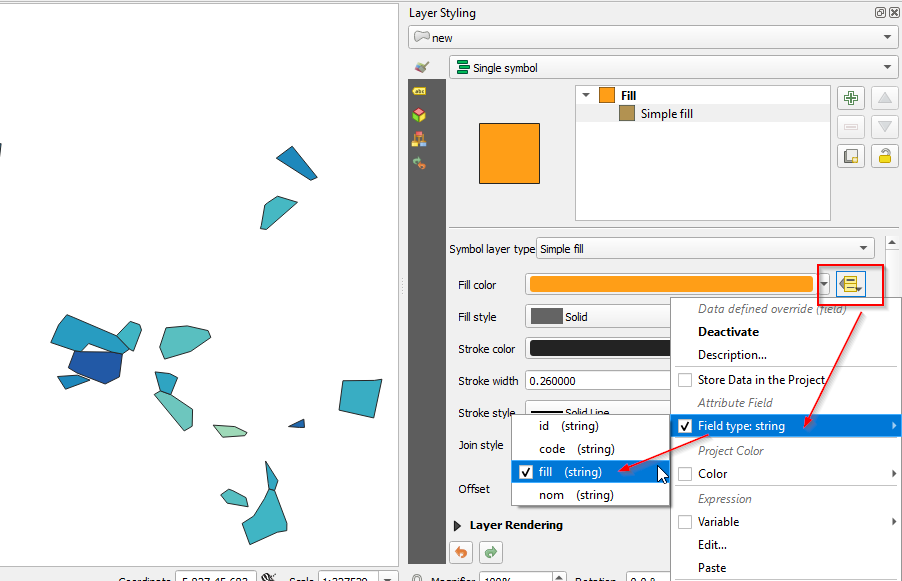
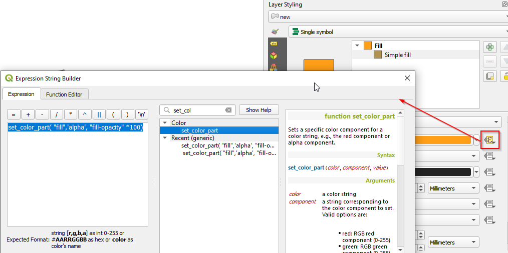
I constructed a GeoJSON file (exemple below) that works fine with http://geojson.io. This GeoJSON file has style properties e.g. 'fill' (hex colour) and 'fill-opacity'. They appear on geojson.io but when I open the file in QGIS 3.10 by adding a vector layer, the colours properties don't show.
{"type":"FeatureCollection", "features": [
{"type":"Feature","geometry":{"type":"Polygon","coordinates":[[[4.904782,46.160867],[4.932978,46.183458],[4.958471,46.153297],[4.926307,46.119968],[4.909106,46.129304],[4.903015,46.157966],[4.904782,46.160867]]]},"properties":{"code":"01001","densite":48.9,"fill":"#33a7c2","fill-opacity":0.5,"nom":"L'Abergement-Clémenciat","population":767,"stroke-width":0,"surface":15.7},"id":"0"},
{"type":"Feature","geometry":{"type":"Polygon","coordinates":[[[5.404077,46.007933],[5.426148,46.030981],[5.441272,46.025699],[5.444129,46.017196],[5.431219,45.983352],[5.424755,45.986633],[5.404077,46.007933]]]},"properties":{"code":"01002","densite":26.7,"fill":"#40b5c4","fill-opacity":0.5,"nom":"L'Abergement-de-Varey","population":243,"stroke-width":0,"surface":9.1},"id":"1"},
{"type":"Feature","geometry":{"type":"Polygon","coordinates":[[[5.327218,45.956848],[5.33756,45.984154],[5.347269,45.982477],[5.397014,45.981931],[5.413537,45.978836],[5.408842,45.942285],[5.386062,45.930905],[5.341149,45.948446],[5.327218,45.956848]]]},"properties":{"code":"01004","densite":574.7,"fill":"#2259a6","fill-opacity":0.5,"nom":"Ambérieu-en-Bugey","population":14081,"stroke-width":0,"surface":24.5},"id":"2"},
{"type":"Feature","geometry":{"type":"Polygon","coordinates":[[[4.886433,46.016032],[4.909751,46.01918],[4.947804,46.000368],[4.942665,45.979454],[4.927599,45.979931],[4.89574,45.979919],[4.88082,45.985732],[4.886433,46.016032]]]},"properties":{"code":"01005","densite":104.4,"fill":"#1f93c0","fill-opacity":0.5,"nom":"Ambérieux-en-Dombes","population":1671,"stroke-width":0,"surface":16},"id":"3"},
{"type":"Feature","geometry":{"type":"Polygon","coordinates":[[[5.570681,45.753687],[5.58358,45.762878],[5.590151,45.760441],[5.611119,45.749335],[5.614595,45.734707],[5.581117,45.740454],[5.570681,45.753687]]]},"properties":{"code":"01006","densite":18.3,"fill":"#55bec1","fill-opacity":0.5,"nom":"Ambléon","population":110,"stroke-width":0,"surface":6},"id":"4"},
{"type":"Feature","geometry":{"type":"Polygon","coordinates":[[[5.299163,45.997168],[5.31167,46.025402],[5.324878,46.041649],[5.334895,46.037575],[5.404077,46.007933],[5.424755,45.986633],[5.413537,45.978836],[5.397014,45.981931],[5.359756,45.995581],[5.347269,45.982477],[5.33756,45.984154],[5.299163,45.997168]]]},"properties":{"code":"01007","densite":79.9,"fill":"#289cc1","fill-opacity":0.5,"nom":"Ambronay","population":2684,"stroke-width":0,"surface":33.6},"id":"5"},
{"type":"Feature","geometry":{"type":"Polygon","coordinates":[[[5.309871,45.942847],[5.34196,45.945042],[5.361923,45.937116],[5.322747,45.922551],[5.309871,45.942847]]]},"properties":{"code":"01008","densite":144.2,"fill":"#1e88bc","fill-opacity":0.5,"nom":"Ambutrix","population":750,"stroke-width":0,"surface":5.2},"id":"6"},
{"type":"Feature","geometry":{"type":"Polygon","coordinates":[[[5.642366,45.807903],[5.662188,45.776358],[5.656838,45.760535],[5.64793,45.763158],[5.646657,45.771722],[5.642366,45.807903]]]},"properties":{"code":"01009","densite":48,"fill":"#33a7c2","fill-opacity":0.5,"nom":"Andert-et-Condon","population":336,"stroke-width":0,"surface":7},"id":"7"},
{"type":"Feature","geometry":{"type":"Polygon","coordinates":[[[5.759821,45.889161],[5.766034,45.936107],[5.816108,45.936625],[5.828334,45.938518],[5.815207,45.87666],[5.759821,45.889161]]]},"properties":{"code":"01010","densite":38,"fill":"#39adc3","fill-opacity":0.5,"nom":"Anglefort","population":1124,"stroke-width":0,"surface":29.6},"id":"8"},
{"type":"Feature","geometry":{"type":"Polygon","coordinates":[[[5.641231,46.216895],[5.645631,46.22045],[5.661482,46.230984],[5.693443,46.22128],[5.643649,46.177811],[5.634104,46.179186],[5.635595,46.184271],[5.641231,46.216895]]]},"properties":{"code":"01011","densite":25.5,"fill":"#46b8c3","fill-opacity":0.5,"nom":"Apremont","population":383,"stroke-width":0,"surface":15},"id":"9"},
{"type":"Feature","geometry":{"type":"Polygon","coordinates":[[[5.473186,45.989872],[5.483332,46.020687],[5.517273,46.023749],[5.550525,46.01624],[5.554992,46.005325],[5.522918,45.983055],[5.481082,45.970653],[5.473186,45.989872]]]},"properties":{"code":"01012","densite":15,"fill":"#59bfc0","fill-opacity":0.5,"nom":"Aranc","population":326,"stroke-width":0,"surface":21.7},"id":"10"},
{"type":"Feature","geometry":{"type":"Polygon","coordinates":[[[5.464421,45.914082],[5.474257,45.919993],[5.490901,45.913944],[5.525779,45.890373],[5.525134,45.863399],[5.512397,45.855919],[5.464421,45.914082]]]},"properties":{"code":"01013","densite":10.5,"fill":"#6dc6be","fill-opacity":0.5,"nom":"Arandas","population":148,"stroke-width":0,"surface":14.1},"id":"11"},
{"type":"Feature","geometry":{"type":"Polygon","coordinates":[[[5.659473,46.2918],[5.684926,46.31082],[5.725034,46.261067],[5.714583,46.256425],[5.659473,46.2918]]]},"properties":{"code":"01014","densite":142.6,"fill":"#1e88bc","fill-opacity":0.5,"nom":"Arbent","population":3379,"stroke-width":0,"surface":23.7},"id":"12"},
{"type":"Feature","geometry":{"type":"Polygon","coordinates":[[[5.604925,45.708015],[5.623456,45.719947],[5.640689,45.747767],[5.64793,45.763158],[5.656838,45.760535],[5.676472,45.708344],[5.676312,45.696625],[5.661048,45.694019],[5.617312,45.674177],[5.604925,45.708015]]]},"properties":{"code":"01015","densite":28.3,"fill":"#40b5c4","fill-opacity":0.5,"nom":"Arboys en Bugey","population":640,"stroke-width":0,"surface":22.6},"id":"13"},
{"type":"Feature","geometry":{"type":"Polygon","coordinates":[[[4.914201,46.481352],[4.929086,46.504022],[5.006992,46.477989],[5.006579,46.461765],[4.989191,46.459813],[4.914201,46.481352]]]},"properties":{"code":"01016","densite":26.4,"fill":"#40b5c4","fill-opacity":0.5,"nom":"Arbigny","population":462,"stroke-width":0,"surface":17.5},"id":"14"},
{"type":"Feature","geometry":{"type":"Polygon","coordinates":[[[5.465818,45.950228],[5.489177,45.947562],[5.501823,45.940984],[5.490901,45.913944],[5.474257,45.919993],[5.465818,45.950228]]]},"properties":{"code":"01017","densite":56.2,"fill":"#2fa4c2","fill-opacity":0.5,"nom":"Argis","population":438,"stroke-width":0,"surface":7.8},"id":"15"},
{"type":"Feature","geometry":{"type":"Polygon","coordinates":[[[5.558633,45.865141],[5.593227,45.862867],[5.612849,45.853302],[5.609256,45.848315],[5.573841,45.845877],[5.558633,45.865141]]]},"properties":{"code":"01019","densite":3.8,"fill":"#9ed9b8","fill-opacity":0.5,"nom":"Armix","population":26,"stroke-width":0,"surface":6.9},"id":"16"},
{"type":"Feature","geometry":{"type":"Polygon","coordinates":[[[4.801092,46.001306],[4.801745,46.007185],[4.808435,46.007398],[4.822385,46.004403],[4.837319,45.973237],[4.801092,46.001306]]]},"properties":{"code":"01021","densite":248,"fill":"#1f78b4","fill-opacity":0.5,"nom":"Ars-sur-Formans","population":1389,"stroke-width":0,"surface":5.6},"id":"17"},
{"type":"Feature","geometry":{"type":"Polygon","coordinates":[[[5.703578,45.874708],[5.704561,45.861516],[5.696419,45.861517],[5.678995,45.862864],[5.703578,45.874708]]]},"properties":{"code":"01022","densite":371.8,"fill":"#2168ad","fill-opacity":0.5,"nom":"Artemare","population":1227,"stroke-width":0,"surface":3.3},"id":"18"},
{"type":"Feature","geometry":{"type":"Polygon","coordinates":[[[4.865908,46.375624],[4.887947,46.402769],[4.897991,46.399032],[4.896086,46.384523],[4.876317,46.369452],[4.865908,46.375624]]]},"properties":{"code":"01023","densite":13.4,"fill":"#5fc1c0","fill-opacity":0.5,"nom":"Asnières-sur-Saône","population":63,"stroke-width":0,"surface":4.7},"id":"19"},
{"type":"Feature","geometry":{"type":"Polygon","coordinates":[[[5.148056,46.298647],[5.219786,46.315016],[5.217267,46.292878],[5.16267,46.255984],[5.150862,46.275507],[5.148056,46.298647]]]},"properties":{"code":"01024","densite":173,"fill":"#1e83ba","fill-opacity":0.5,"nom":"Attignat","population":3270,"stroke-width":0,"surface":18.9},"id":"20"}
]}


