I give it a try, but as @Hornbydd said in comment, you would better do some testing to validate or invalidate this hypothesis.
Hypothesis
On floating point division
It may be related to how numbers are stored by the device, in other words, how are handled integer vs floating point arithmetic. Maybe the device manufacturer decided to represent floating point number as an approximate given by two integer (which division tends towards the "right" value) and because it is sufficient to store it this way. In that case you can spare memory.
For example, if you simply take the division (here in Python):
>>> import math
>>> 180*(74041/49085)/math.pi
86.42633820776467
Now you can try to figure out how is defined the 0 for your device (see e.g. Fig.1).
This thread can help: https://stackoverflow.com/questions/24516794/what-sensor-can-be-used-to-detect-rotation-when-upright
And this is some documentation from Apple: https://developer.apple.com/documentation/coremotion/getting_raw_gyroscope_events

Fig.1 Apple definition of reference frame for their smartphones
But beware, there can be some extra rotation(s) to apply between the coordinate system of the device, and the one used by the camera (they also can be the same of course, you have to figure it out).
On Norths
On your second question, I let you explore the solution on your own because it depends on where you actually are (i.e. in which country).
There is two things;
Magnetic declination
First, the magnetic declination which relate the true North as defined by the rotation axis of the Earth and the magnetic North.
It is possible that this difference, which slowly varies over time because of the movement of the magnetic North, is embedded somehow in your device, hence the two same numbers. If not the case, you have to take this difference into consideration.
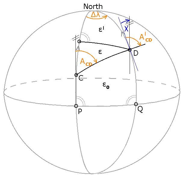
Meridian convergence
Then, depending on what you want to do with your data, especially if you would like to map them, i.e. project them on cartographic plane, you would have to take into account the difference between the true North defined by the rotation axis of the Earth, and the cartographic North of the place (country mainly) you're living. Therefore, it depends on how is your local cartographic projection defined.
This difference is called meridian convergence (Fig. 2).

Fig.2 The meridian convergence
Further readings
- On floating point arithmetic
https://stackoverflow.com/a/24588581/6630397
https://en.wikipedia.org/wiki/Floating-point_arithmetic
https://web.fhnw.ch/plattformen/llp/vorlesungsunterlagen/threading/intandfloat.pdf
Checkout the StackExchange questions!


